
Tambosee
| Tambosee | ||
|---|---|---|

|
||
| Geographical location | Canton of Graubünden , Switzerland | |
| Tributaries | Tambobach | |
| Drain | Tambobach → Hinterrhein → Rhine → North Sea | |
| Location close to the shore | Splügen | |
| Data | ||
| Coordinates | 742 752 / 152602 | |
|
||
| Altitude above sea level | 2328 m above sea level M. | |
| surface | 2,450 3 ha | |
| length | 186 m | |
| width | 90 m | |
| scope | 830 m | |
| Catchment area | 1.68 km² | |

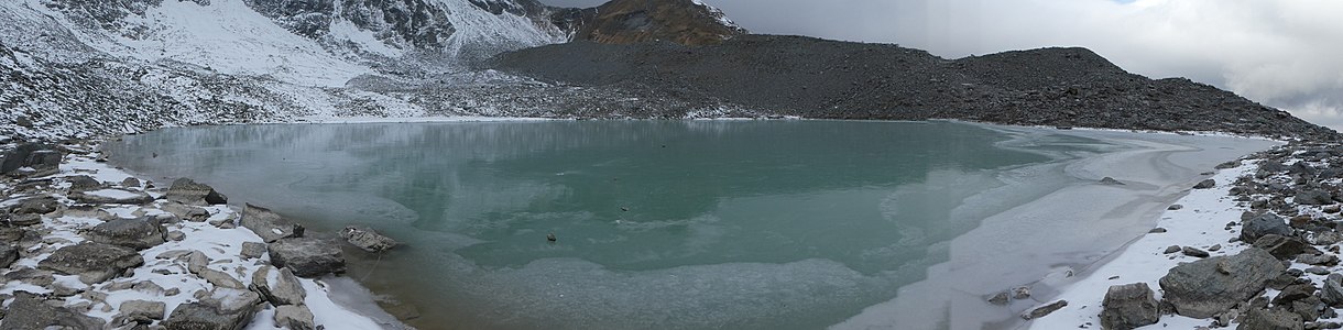
The Tambosee (Tambo probably from Lombard tambor 'drum' , but factually unclear) is a mountain lake in the municipality of Rheinwald in the canton of Graubünden in the Swiss Alps . It is located at 2328 m above sea level. M.
Location and surroundings

The lake is located northeast of Pizzo Tambo below the Tambo glacier in a basin above the Tamboalp above the village of Splügen . Other small lakes in the same basin not far from the Tambosee are not named on the map. Two of them above the Tambosee at 2330 m and 2345 m are only slightly smaller than the Tambosee.
The valley basin lies above the Tamboalp in a valley that runs parallel to the northern ramp of the Splügen Pass . The water flows as a Tambobach northwards down to the Tamboalp and flows southeast of Medels in the Rheinwald into the Hinterrhein .
Accesses
Over the Tamboalp
- Starting point: Splügen ( 1457 m )
- Via: Windigstafel, Tamboalp, Stotzhalta
- Difficulty: T3 until Stotzhalta as trail white-red-white highlighted
- Time required: 2¾ hours
About Lattastafel
- Starting point: Splügen ( 1457 m )
- Via: Blachtaboda, Lattastafel, Bi den Trög ( 2131 m ), In da Steina
- Difficulty: T3 until the Bi Trög as trail white-red-white highlighted
- Time required: 3 hours
- Alternative: instead of from Splügen, drive to Isabrüggli ( 1768 m ) on the Splügenpassstrasse and walk to the Lattastafel (- 45 minutes)
gallery

The first lake at 2330 m , 2 meters above the Tambosee.
The second lake at 2345 m , 17 meters above the Tambosee.

All three lakes in the basin in one picture, the Tambosee is the lowest (rearmost).


literature
- Manfred Hunziker: Club guide, Bündner Alps . Obverse. 1st edition. tape III . SAC publishing house, 1994, ISBN 3-85902-140-0 .
- Hiking 2017 . Tours, ideas, training, information. Bündner Wanderwege, 2017, p. 62 .
- National map of Switzerland, sheet 1254 Hinterrhein, 1: 25,000, Federal Office of Topography, 2012 edition.
- National map of Switzerland, sheet 1255 Splügenpass, 1: 25,000, Federal Office of Topography, 2012 edition.
Web links
- Tambosee on schweizersee.ch
- www.hikr.org Various tour reports
Individual evidence
- ↑ Andrea Schorta: How the mountain got its name . Small Rhaetian name book with two and a half thousand geographical names of Graubünden. Terra Grischuna Verlag, Chur and Bottmingen / Basel 1988, ISBN 3-7298-1047-2 , p. 139 .