Timor Sea
The Timor Sea is about 61,500 square kilometers large sea bordering the Indian Ocean with a maximum depth of 3300 meters.
geography
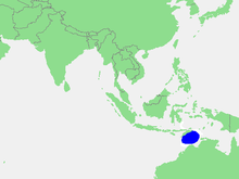
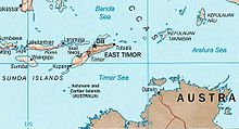
The Timor Sea, on average 406 meters deep, stretches between the Australian north coast, the island of Timor and the Arafura Sea in the east. In the northwest lies the Sawu Sea , in the north the Banda Sea . The Timor Trench, which is over 3000 meters deep, runs under the Timor Sea. The Timorese call the rough Timor Sea on Tetum Tasi Mane, the men's sea, in contrast to the calm sea in the north, the Tasi Feto , the women's sea .
The Timor Sea is part of the Indonesian ocean current ( Indonesian through flow, ITF) and their biggest passage. The ITF is important to the global climate as it provides a route for warm, fresh water from the Pacific to the Indian Ocean . It represents the upper arm in global heat exchange.
Ocean currents as a global conveyor belt , simplified
Indonesian ocean current ( Indonesian through flow, ITF ). 1 Sv = 10 6 m³ · s −1 .
During the last glacial period , the Lombok Strait was less receptive due to the lower sea level, so the flow rate in the Timor Sea should have increased. The opposite was the case, however, because the global conveyor belt was less efficient.
raw materials
There are extensive oil and gas reserves under the Timor Sea. The deposits are among the richest in the Asia-Pacific region. Australia and East Timor fought for several years over the production rights and profit distribution from the Timor Gap . In the area, Australia's territorial claims, which were based on the principle of the continental shelf , overlapped with those of East Timor. East Timor followed its former colonial power Portugal , who demanded that the dividing line overseas should be exactly halfway between the two countries.

The principle of the center line has also been enshrined in the United Nations Convention on the Law of the Sea since 1982 , but did not come into force until 1994. Australia negotiated early with Indonesia , which held East Timor from 1975 to 1999, more favorable treaties. Australia even violated UN resolutions by recognizing Indonesia's sovereignty over East Timor. After East Timor's independence, Australia had to renegotiate, putting the financially troubled East Timor, which is urgently dependent on oil money, under pressure. While East Timor demanded the definition of the border in the middle between the countries according to the UN Convention on the Law of the Sea, Canberra insisted on an orientation according to the course of the edge of the Australian continental plate. In Australia, in January 2004, opponents of John Howard's government policy founded the Timor Sea Justice Campaign, which campaigned for a fair distribution of oil reserves.
On January 12, 2006, the two countries agreed in the CMATS contract to share the profits from the oil and gas deposits in the Greater Sun Rise Area 50:50. A 50-year moratorium on the maritime border was agreed without East Timor waiving its claims. The dispute broke out again in 2013 when it was discovered that Australia had wiretapped the East Timorese cabinet during the negotiations . The dispute was only ended in 2018 with a new border treaty. East Timor is planning major infrastructure measures and the construction of a natural gas refinery on the south coast of Timor. The project is named after the Timor Sea Tasi Mane .
In 2009, after a fire on the Montara production platform, around 4.5 million liters of crude oil ran into the Timor Sea over a period of 10 weeks. A chemical sprayed on the oil slick also created a poisonous mixture, so that the ecosystem there will be impaired for a long time.
Web links
Individual evidence
- ^ Maeve McCusker, Anthony Soares Soares: Islanded Identities: Constructions of Postcolonial Cultural Insularity. 2011, ISBN 90-420-3406-8 , p. 170.
- ↑ C. Fetter: Applied Hydrogeology . Prentice-Hall, New Jersey 2001, ISBN 0-13-088239-9 , p. 41.
- ↑ M. Selby: Hillslope Materials and Processes . Oxford University Press, New York 2005, ISBN 0-19-874183-9 , p. 216.
- ↑ J. Sprintall, SE Wijffels, R. Molcard, and I. Jaya: Direct estimates of the Indonesian Throughflow entering the Indian Ocean: 2004-2006. PDF. In: Journal of Geophysical Research - Oceans. 114, 19, 2009.
- ^ A b Vivek Kumar Pandey, Avinash Chand Pandey: Heat transport through Indonesian throughflow. PDF. In: J. Ind. Geophys. Union. Volume 10, No. 4, October 2006, pp. 273-277. ITF heat transport result from POM model.
- ↑ Ann Holbourn, Wolfgang Kuhnt, Jian Xu: Indonesian throughflow variability during the last 140 ka: the Timor Sea outflow. In: Geological Society, London, Special Publications. January 1, 2011, pp. 283-303.
- ↑ Ute Kehse: South Seas in Oil. In: Berliner Zeitung . November 16, 2009, accessed June 16, 2015 .
Coordinates: 12 ° S , 126 ° E


