Tauernkogel (Granatspitzgruppe)
| Tauernkogel | ||
|---|---|---|
|
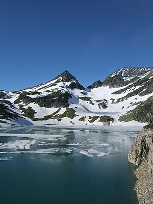
Kalser Tauernkogel from the north, from the Weisssee dam |
||
| height | 2683 m above sea level A. | |
| location | Salzburg and Tyrol , Austria | |
| Mountains | Garnet group | |
| Dominance | 0.7 km → Granatspitze | |
| Notch height | 150 m ↓ Rotkogelscharte | |
| Coordinates | 47 ° 7 '17 " N , 12 ° 36' 59" E | |
|
|
||
| Normal way | From the Rudolfshütte via the Kalser Tauern | |
The Tauernkogel (also Kalser Tauernkogel ) is 2683 m above sea level. A. high mountain in the Granatspitz group of the Hohe Tauern in Austria . The summit is located exactly on the borderline between East Tyrol and Salzburg not far from the Kalser Tauern , a transition between the Pinzgau in the north and East Tyrol in the south.
The Kalser Tauernkogel is the first elevation in the ridge that goes from the Kalser Tauern to the Granatspitze ( 3086 m above sea level ). On the opposite side of the Kalser Tauern is the Medelzkopf ( 2760 m ).
Normal way
From the Rudolfshütte , which can be reached by cable car from Enzingerboden, a marked trail leads north in about 1½ hours to the Kalser Tauern . From the saddle, turn west and follow the climbing tracks. Partly over the ridge, the last on the northeast flank, you reach the summit of the Kalser Tauernkogel after about another half hour. The ascent is partially insured with wire ropes.
Literature and map
- Willi End : Alpine Club Leader Glockner and Granatspitz Group ; Bergverlag Rudolf Rother ; 10th edition 2003; ISBN 978-3-7633-1266-5
- Alpine Club map sheet 39, 1: 25,000, garnet group . Austrian Alpine Association, 2002, ISBN 3-928777-75-0

