Te Mata
| Te Mata | ||
|---|---|---|
|
Te Mata (back tip) |
||
| height | 399 m | |
| location | Hastings District , Hawke's Bay (Region) , North Island , New Zealand | |
| Mountains | Kaokaoroa Range | |
| Coordinates | 39 ° 42 ′ 6 ″ S , 176 ° 54 ′ 33 ″ E | |
|
|
||
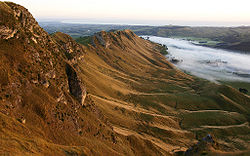
The Te Mata is a 399 m high mountain in the eastern foothills of the Kaokaoroa Range in the region Hawke's Bay on the North Island of New Zealand . The mountain gained importance with the establishment of the Te Mata Trust Park in 1927 and the views of the entire Hastings District and beyond from the mountaintop. A twelve-kilometer road leads from Havelock North to the summit.
geography
The mountain range on both sides of the Te Mata extends along the Tukituki River in a northeastern direction and is bounded in the northeast by the river. To the northwest of the mountain range opens up the vastness of the Heretaunga Plains and in the southwest it continues over the 490 m high Mount Erin into the Kaokaoroa Range.
geology
The mountain range consists mainly of limestone and was originally an ocean floor . This mountain range was ultimately created by the tectonic shifts and upheavals caused by the sliding of the Australian Plate onto the Pacific Plate on the east coast of the North Island of New Zealand.
Māori legend
In the Māori legends, the mountain is known as the sleeping giant Te Mata O Rongokako , Māori chief and ancestor of the Iwi of the Kahungunu , or translated as the face of the Rongokako . It is said that the Māori chief fell in love with the daughter of the leader of the Iwi of Heretaunga and therefore refrained from attacking the tribe. In order to be able to have his beloved, however, he was given some difficult tasks to solve so that he could prove that he was the right one. He passed all tests, but tried to eat his way through the hills, failed, died, and became a mountain.
history
In 1854, the year he arrived in New Zealand, John Chambers , son of an English Quaker family , bought 600 acres of land in the Tarawera area of the Bay of Plenty . But controversy over the land made him swap land for land around Te Mata . That took some time and in 1862 the purchase was perfect. With further land purchases and good sheep-raising deals, Chambers became the major landowner and most influential farmer in the area with 18,000 acres and 35,000 sheep . Shortly before his death, he divided the land among his three sons, 98 hectares of which were donated to Hawke's Bay County Council in 1927 to enable the establishment of the Te Mata Trust Park .
literature
- Te Mata Trust Park , Flyer, Hastings District Council, Hastings.
- Information boards in the park and on Mount Te Mata, Te Mata Trust Park, Hastings.
Individual evidence
- ↑ Ian McGibbon : Chambers, John . In: Dictionary of New Zealand Biography . Ministry for Culture & Heritage , September 1, 2010, accessed August 24, 2012 .


