
Thanon Ratchadamnoen

Ratchadamnoen Avenue ( Thai ถนน ราชดำเนิน [ tʰànǒn râːtt͡ɕʰádamnɤːn ], colloquially [ COUNCIL damnɤːn ]; German Ratchadamnoen Road and Ratchadamnoen Avenue ; English Ratchadamnoen Avenue ) is a boulevard in the center of the Thai capital Bangkok (districts Phra Nakhon , Pom Prap Sattru Phai and Dusit ). It is 3.3 kilometers long and connects the Grand Palace , which was the residence of the Thai kings until the beginning of the 20th century, with the newer Dusit Palace , in which the monarchs have mostly resided since 1901. The name of the street translates as "Royal Way", "Royal Processional Way", or "Royal Progress". It is divided into three sections: the inner (Thanon Ratchadamnoen Nai), middle (Thanon Ratchadamnoen Klang) and outer Ratchadamnoen boulevard (Thanon Ratchadamnoen Nok).
history
The layout of the boulevard is influenced by King Chulalongkorn's trip to Europe in 1897. The Mall in London, Unter den Linden in Berlin and the Parisian boulevards, namely the Avenue des Champs-Élysées , may have served as models . It is based on enlightening ideas of modernity, visibility and a large-scale geometric order. By copying prominent features of the then common European urbanism, Chulalongkorn wanted to emphasize the affiliation of Bangkok and Siam to the western ( Victorian -influenced) world. The construction of Ratchadamnoen Boulevard was part of the first major, planned redesign of Bangkok since its founding in 1782. The boulevard was built with three parallel lanes, separated from each other by double rows of trees and lined with shady footpaths. The esplanade was completed in 1899. In 1902 one of Chulalongkorn's sons bought the first car, and in the following six years the royal family bought over 300 more. The king and other members of the aristocracy, who, following his example, also settled in Dusit, also used to cycle along the promenade in the evening hours.

After the coup d'état in 1932 , which ended the absolute monarchy, the middle Ratchadamnoen boulevard was widened. The rows of mahogany trees fell victim to the expansion of this section and are only preserved today along the outer Ratchadamnoen boulevard. During this time, the characteristic, four-storey commercial buildings in Art Deco style were built along Thanon Ratchadamnoen Klang. In 1939, the then Prime Minister Plaek Phibunsongkhram had the democracy monument erected in the middle of Ratchadamnoen Klang Boulevard to commemorate Thailand's transition to constitutionalism and the entry into force of the first constitution in 1932. It is roughly halfway between the Grand Palace, where the king had to take an oath on the constitution, and the Anantasamakhom throne hall, where parliament met after the revolution. With its location it symbolizes the break with the absolute monarchy. Just as the Ratchadamnoen Klang Boulevard is apostrophized as the “Thai Champs-Elysées”, Phibunsongkhram, who had studied in France, imagined the democracy monument as Bangkok's equivalent to the Arc de Triomphe .
The Democracy Monument Square and Ratchadamnoen Boulevard were the sites of mass demonstrations during the popular uprising in October 1973 , the " Black Corn " in 1992 and the People's Alliance for Democracy ("Yellow Shirts") protests against the government of Thaksin Shinawatra in 2006. Ratchadamnoen Boulevard thus symbolizes both a road closely associated with royalty and the path to democracy.
Every year on the occasion of the king's birthday celebration, the Thanon Ratchadamnoen is decorated with lights, banners and portraits of the monarch.
course

Thanon Ratchadamnoen Nai
The inner Ratchadamnoen Boulevard (Thanon Ratchadamnoen Nai; ถนน ราชดำเนินใน ) is the shortest section with a length of 550 meters. It begins at the southeast end of Sanam Luang , the northeast corner of the wall of the Great Palace , the shrine with the city pillar ( Lak Müang ) and the Ministry of Defense . It runs in a northerly direction, along the eastern edge of the Sanam Luang, to its northeast curve, where there is a shrine with the statue of Phra Mae Thorani and a statue of the three-headed elephant Erawan . There it turns right and flows into the Thanon Ratchadamnoen Klang. The Supreme Court of Thailand is located in the Thanon Ratchadamnoen Nai.
Thanon Ratchadamnoen Klang
Middle Ratchadamnoen Boulevard (Thanon Ratchadamnoen Klang; ถนน ราชดำเนินกลาง ) is 1.3 kilometers long. It begins at the northeast end of the Sanam Luang and runs from there in an easterly direction to the Phan Fa Lilat Bridge over the Khlong Bang Lam Phu , the canal that bounded the original city center (the Rattanakosin Island). It is interrupted by a large, seven-lane roundabout with the democracy monument in the middle . The four-story commercial buildings from the 1930s that line it are characteristic of Ratchadamnoen-Klang-Boulevard. They are under monument protection. In this street are the Royal Hotel Rattanakosin from 1942, the memorial for October 14, 1973 , the headquarters of the Deves Insurance, the Queen Sirikit Art Hall, Wat Ratchanatdaram with the Loha Prasat and the statue of Rama III. and the Mahakan Fort, part of the former city fortifications.

Thanon Ratchadamnoen Nok

At the Phan Fa Lilat intersection, the road bends again and continues north. This is where the outer Ratchadamnoen Boulevard (Thanon Ratchadamnoen Nok; ถนน ราชดำเนินนอก ) begins , at 1.5 kilometers the longest section. It ends at the royal plaza with the equestrian statue of Ramas V in front of the Anantasamakhom throne hall . In between are the ministries for agriculture, transport, education as well as tourism and sport, the Ratchadamnoen Muai Thai Stadium, the headquarters of the Thai Army, the headquarters of the Tourism Authority of Thailand (TAT) and the Bangkok UN building, on which the Economic and Social Commission for Asia and the Pacific sits. South of the Makkhawan-Rangsan Bridge over the Khlong Phadung Krung Kasem , the road forms the border between the districts of Phra Nakhon and Pom Prap Sattru Phai, to the north of it it lies entirely in the district of Dusit. The government house, the official seat of the Thai Prime Minister, and Wat Benchamabophit are located in a side street .
gallery
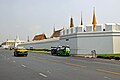
Wall of the Great Palace
Shrine with the city column

Erawan statue at Sanam Luang

Royal Hotel Rattanakosin
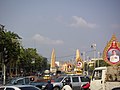
Thanon Ratchadamnoen Sound and Democracy Monument

Democracy Monument

Typical commercial building on Thanon Ratchadamnoen Klang

Headquarters of the Deves insurance

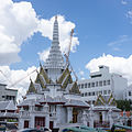
Wat Ratchanatdaram with Loha Prasat

Mahakan Fort

Entrance to the Ratchadamnoen Stadium

UN building

Makkhawan Rangsan Bridge

Equestrian statue of Ramas V and Anantasamakhom throne hall


literature
- Kim Dovey: Framing Places. Mediating power in built form. 2nd edition, Routledge, 1999, Chapter 7 Paths to Democracy - Bangkok , pp. 97-113.
- Maryvelma O'Neil: Bangkok. A cultural history. Oxford University Press, Oxford / New York 2008, Chapter 5 Rajdamnern Avenue , pp. 96-110.
Individual evidence
- ↑ a b c Dovey: Framing Places. 1999, p. 100.
- ↑ a b Pornpan Chinnapong: Bangkok's Sanam Luang (the royal ground). From a historic plaza to a civic space. In: Globalization, the City and Civil Society in Pacific Asia. The social production of civic spaces. Routledge, 2008, p. 257
- ↑ Maurizio Peleggi: Thailand. The Worldly Kingdom. Reaction Books, London 2007, p. 33.
- ^ A b c William Warren: Bangkok. Reaction Books, London 2002, p. 33.
- ↑ a b Serhat Ünaldı: Politics and the City. Protest, Memory, and Contested Space in Bangkok. In: Contemporary Socio-Cultural and Political Perspectives in Thailand. Springer, 2014, p. 213.
- ↑ Pornpan Chinnapong: Bangkok's Sanam Luang. 2008, p. 256.
- ↑ Peleggi: Thailand. 2007, p. 34.
- ^ O'Neil: Bangkok. 2008, pp. 97-98.
- ↑ Kamthorn Kulachol: Bangkok Morphology and Its Old Settlements - An Overview. In: Manusya - Journal of Humanities , Volume 6, No. 2, pp. 81-100, at p. 89.
- ^ Dovey: Framing Places. 1999, p. 103.
- ^ O'Neil: Bangkok. 2008, p. 99.
- ^ Ross King, Kim Dovey: Interstitial Metamorphoses. Informal Urbanism and the Tourist Gaze. In: Environment and Planning D: Society and Space , Volume 31, No. 6, 2013, pp. 1022-1040.
- ↑ Ka F. Wong: Visions of a Nation. Public Monuments in Twentieth-Century Thailand. White Lotus Press, Chiang Mai 2006, p. 65.
- ^ O'Neil: Bangkok. 2008, pp. 99-100.
- ^ Dovey: Framing Places. 1999, pp. 104-106.
- ^ O'Neil: Bangkok. 2008, p. 101.
- ^ Dovey: Framing Places. 1999, pp. 108-110.
- ^ Dovey: Framing Places. 1999, p. 111.
- ↑ Ünaldı: Politics and the City. 2014, p. 214.
- ^ Dovey: Framing Places. 1999, p. 112.