
Avenue des Champs-Élysées
| Avenue des Champs-Élysées | |
|---|---|
| location | |
| Arrondissement | 8th. |
| quarter | Champs-Élysées Faubourg-du-Roule |
| Beginning | Place de la Concorde |
| The End | Place Charles-de-Gaulle |
| morphology | |
| length | 1.91 km |
| width | 70 m |
| history | |
| Emergence | 1670 |
| designation | March 2, 1864 |
| Original names | Grand-Cours Allée du Roule avenue de Neuilly |
| Coding | |
| Paris | 1736 |
.jpg)
The Avenue des Champs-Élysées [ avəˌnydeˌʃɑ̃zeliˈze ], also known as Champs-Élysées or colloquially known as Les Champs , is a boulevard in the French capital, Paris . It is 70 meters wide and 1910 meters long, starts at Place de la Concorde and ends at Place Charles-de-Gaulle . The Champs-Élysées form the central part of the Ax historique visual axis between the Obelisque (Place de la Concorde) and the Arc de Triomphe (Place Charles-de-Gaulle).
Surname
The avenue des Champs-Élysées has had its current name since 1789. It means "avenue of the Elysian fields" and is derived from the blessed area of Elysion , to which, according to Greek mythology, selected heroes are transferred. The tree-lined promenade was called the Grand Cours and should not be confused with the Cours-la-Reine . It was first officially called Grande Allée du Roule (1670), then Avenue du Palais des Tuileries (1680), finally in the lower area Avenue de la Grille Royale and in the upper Avenue de Neuilly (1778).
location
In the lower eastern area, the avenue is lined on both sides by a park , the Jardin des Champs-Élysées . There are two former exhibition halls of the World Exhibition of 1900, the Petit Palais with the municipal museum of fine arts and the Grand Palais with the scientific museum known as the Palais de la Découverte . To the north of it, the garden of the Élysée Palace , the official seat of the French President since 1873, spills over into the Jardin des Champs-Élysées . Not far from there is the Théâtre Marigny , a little further west the Théâtre du Rond-Point . The Théâtre des Champs-Élysées is on a side street.
Beyond the intersection of the Rond-Point des Champs-Élysées , the upper, western section of the Champs-Élysées is lined with shops, cinemas, cafés and restaurants, such as the Fouquet’s . The avenue ends at Place Charles-de-Gaulle with the Arc de Triomphe . From 1970 to 2015 this square could be crossed in the Tunnel de l'Étoile to the Avenue de la Grande Armée .
Line of sight
The Ax historique runs well beyond the length of the Champs-Élysées. It begins in the east at the Palais du Louvre (built in the 12th century) and the Arc de Triomphe du Carrousel (built 1807-1809) and continues through the Tuileries Gardens to Place de la Concorde with the Luxor obelisk . This is where the Avenue des Champs-Élysées begins , at the western end of which the Arc de Triomphe (built 1806–1836) with the tomb of the unknown soldier can be found. This is followed by the avenue de la Grande Armée leading out of the city and, beyond the city limits in the suburb of Neuilly-sur-Seine, the avenue Charles-de-Gaulle . In its extension, the Pont de Neuilly bridge leads over the Seine to the satellite town of La Défense (from 1958), where the line of sight with the Grande Arche (opened in 1989) is provisionally terminated.

Champs-Élysées as seen from the Arc de Triomphe in an easterly direction
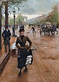
Jean Béraud (1848–1935):
La Modiste sur les Champs-Élysées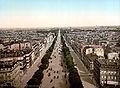
Champs-Élysées before 1897

Grand Palais, view from the Avenue des Champs-Élysées
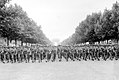
American troops march down the avenue on August 29, 1944


history

The area beyond the gardens of the Palais des Tuileries originally consisted of fields and gardens. In 1616, Maria de Medici had the northern bank of the Seine bordered in the southern area of this area with the so-called Cours la Reine (later also known as Petit Cours ), a promenade ( French cours ) that still exists today and is planted with rows of trees .
Under Louis XIV and on the initiative of Minister Colbert , André Le Nôtre designed and built a second promenade further north in 1667 , parallel to the Cours la Reine . Drawn exactly in the extension of the central avenue of the Tuileries Garden, this Grand-Cours , from which the Champs-Elysées emerged, at the same time formed a west-facing axis.
In 1724, the garden axis of the Tuileries Gardens was connected to the promenade and extended to Place de l'Étoile (today Place Charles-de-Gaulle ). The Plan de Turgot of 1739 shows that another strip of paths and fields separated the main axis of the Tuileries Gardens from the Avenue des Tuileries (which was a round basin at the site of today's Rond-Point ). The starting point was the Cours de la Reine (still part of the quayside on the Seine today), from which a dirt road separated the Tuileries and the gardens to the west. The "Elysian Fields" were an open space within the Tuileries and all around were planted with groups of trees. To the east, the Louvre (called Vieux Louvre on the maps ) was not yet part of the street, but was surrounded by other buildings. To the west, the Avenue des Champs-Élysées opened to a newly created Place du Pont Tournant , which soon after Louis XV. and is now called Place de la Concorde .
At the end of the 18th century, the Champs-Élysées became very popular, the grown groups of trees now resulted in rectangular clearings (cabinets de verdure) and the gardens of the buildings in the Faubourg Saint-Honoré district bordered the park. The largest of these buildings was the Élysée Palace, completed in 1722. A semicircular house front now formed the northern edge of Rond-Point . The street from Rond-Point to Place de l'Étoile , where twelve streets meet today, was built during the reign of Napoleon I , who wanted not only to fundamentally modernize Paris through large-scale urban development projects, but also to beautify it comprehensively. It was not until 1828 that the avenue came into the possession of the city of Paris, who added footpaths, fountains and gas-powered street lighting.
At the end of the 19th century, the Champs-Élysées then became the boulevard and shopping mile of aristocratic and upper-class Paris, as can be seen in buildings such as the Grand Palais , built for the 1900 World Exhibition . The avenue itself has undergone several structural changes, most recently in 1993 when the walkways were widened. On July 20, 1975, the Tour de France ended on the famous road for the first time .
trade
Due to the high rents, very few citizens now live on the Avenue des Champs-Élysées . The upper floors of the buildings are mainly used as offices for commercial agencies , insurance companies and banks , and on the ground floor there are usually arcades such as the Arcades des Champs-Élysées , shops , restaurants , cafes , cinemas and banks. The dwindling number of airlines and car concessionaires that used to be strongly represented is striking . Even the Paris Chamber of Commerce and Industry (Office de Tourisme de Paris) has left the “expensive mile”. On the other hand, there is an increasing number of shops and restaurants affiliated with retail chains , among which there is no lack of fast food branches.
As early as 1860, the business owners along the avenue joined forces to form a Syndicat d'Initiative et de Défense des Champs-Élysées ("Association for the Promotion and Protection of the Champs-Élysées"), which in 1916 was chaired by Louis Vuitton in converted into an association and has been called Comité des Champs-Élysées since 1980 . This oldest existing committee in Paris aims to maintain or restore the prestige of the Champs-Élysées. It has retained a veto right to the opening of new shops on the Champs-Élysées and wants to enforce extended business hours.
The perfume manufacturer Guerlain , the restaurant Le Fouquet’s and the revue theater Lido are among the long -established and at the same time most prestigious and luxurious companies on the Champs-Élysées . The luxury company Louis Vuitton , which left its historic location on the opposite side of the Champs-Élysées in 1954, has only recently returned .
Worth seeing
.jpg)

- In the gardens of the Champs-Élysées:
- Grand Palais , Petit Palais , garden portal of the Élysée Palace, Théâtre de Marigny, Théâtre du Rond-Point, Guignoltheater (since 1836)
- At the top of the avenue:
- No. 6: Former seat of the Pâtisserie Gloppe
- No. 22: Adidas Store
- No. 25: Hôtel de la Païva (former city palace of the Marquise de la Païva )
- No. 42:. C_42 - Citroën (car exhibition hall Citroën )
- No. 52/60: Virgin Megastore
- No. 53:. Atelier Renault (car showroom Renault )
- No. 68: Guerlain (perfume maker)
- No. 74: FNAC (media chain)
- No. 76/78: Les Arcades des Champs-Élysées or Arcades du Lido (1928), a listed building
- No. 79: Le Rendez-vous Toyota (automotive exhibition hall Toyota )
- No. 95: Lacoste (clothing company)
- No. 99: Hôtel Fouquet's Barrière and Restaurant Le Fouquet's
- No. 101: Louis Vuitton (luxury goods)
- No. 103: Élysées Palace
- No. 104: Aviation Club de France , casino
- # 136. Peugeot Avenue (car exhibition hall Peugeot )
- No. 144-146-150: former Les Portiques gallery (1926, Louis Grossard, architect) with an ensemble of luxurious boutiques and cafés, including a branch of the men's tailor Kniže & Comp, designed by Adolf Loos . The building now houses a cinema complex.
- No. 166: Lido (revue theater)
- No. 118:. Mercedes-Benz (Automobile Exhibition Hall Mercedes-Benz )
- No. 133: Drugstore Publicis (department store)
- In the neighborhood:
Events
On July 14th, the national holiday , the French President will take over the military parade from the stands under the obelisk of the Place de la Concorde . Invited guests then go to the garden party in the Élysée Palace, during which the President gives an interview on television that is followed with interest.
Tour de France
Since 1975, one or two weeks later, the Tour de France has come to an end on the avenue between Place de la Concorde and Place Charles-de-Gaulle . Before that, an annually changing route through Paris and its suburbs has to be completed. The finish line on the northern Champs-Élysées is crossed several times because the approximately 6.5 kilometers long route has to be covered several times under the eyes of thousands of spectators. In 2006 only the eighth passage ended with the finish line. The subsequent award ceremony also takes place here with the Arc de Triomphe as the background for the photo in the life of a professional cyclist .
Metro
The following stations of the Paris Métro are under the Avenue des Champs-Élysées , with Concorde and Charles de Gaulle - Étoile at the ends and Métrolinie 1 running through all five stations.
- Concorde (lines 1 , 8 and 12 )
- Champs-Élysées - Clemenceau (lines 1 and 13 )
- Franklin D. Roosevelt (Lines 1 and 9 )
- George V (Line 1)
- Charles de Gaulle - Étoile (lines 1, 2 , 6 and RER A )
various
On December 2, 1804, the French engineer and chemist Philippe Lebon (* 1767) was found lifeless on the Champs-Élysées. A murderer who was never identified had stabbed him 13 times. The illustrator Émile Bayard created a drawing of the event.
The writer Ödön von Horváth was killed on June 1, 1938 during a thunderstorm on the Champs-Élysées by a falling branch.
music
Joe Dassin immortalized the boulevard in 1969 with his song Les Champs-Élysées . The song was also known in other languages (German, English, Italian, Japanese).
Air quality
In April 2016, Mayor Anne Hidalgo ( PS ) announced that the boulevard would be closed to automobile traffic on the first Sunday of each month from May 2016. Hidalgo had already prescribed a car-free day in October 2015 . The concentration of nitrogen oxides on the boulevard that day was more than 30% below the value on an average Sunday.
More pictures

Avenue de la Grande Armée and Arc de Triomphe in the evening

Arc de Triomphe by day

Arc de Triomphe by night
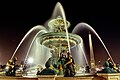
Fountain on the Place de la Concorde

Avenue des Champs-Élysées

Avenue des Champs-Élysées sloping to the east


.jpg)


See also
literature
- The Elyseian Fields . In: Illustrirte Zeitung . No. 13 . J. J. Weber, Leipzig September 23, 1843, p. 204-206 ( books.google.de ).
- Jacques Hillairet: Dictionnaire Historique des Rues de Paris. Éditions de Minuit, Paris 1963, ISBN 2-7073-0092-6
- Fritz Stahl: Paris. A city as a work of art. Mosse, Berlin 1929
Web links
- Data on avenue des Champs-Élysées on the city of Paris website (French)
- The Champs-Elysées district postcards from 1900 to today (French, with machine-generated German translation)
- Documentation about traffic accidents by Frederic Siebert, who runs a shop about 50 meters from the tunnel entrance: The tunnel at the Place de l'Étoile is 20 centimeters lower than most tunnels in France, which despite the sign with a 2.40 m height limit since 40 Constantly leads to accidents for years (approx. 25 per year). Example: February 2010 .
Individual evidence
- ^ Jacques Hillairet: Dictionnaire Historique des Rues de Paris.
- ^ Nomenclature des rues de Paris , official nomenclature of the streets of Paris
- ^ Revue Construction Modern, May 27, 1928
- ^ Photographie de la Galerie des Portiques extraite de la Revue Construction moderne on May 27, 1928
- ↑ Les Portiques Gallery
- ↑ English: Down Waterloo Road (Jason Crest); Japan: with a cover version sung by Daniele Vidal with the refrain “oh champs Elysees” and a version by Kaya
- ↑ AFP : Champs-Elysees bans cars once a month to cut Paris smog. In: theguardian.com. April 26, 2016, accessed April 26, 2016 .
- ↑ Kim Willscher: Paris's first attempt at car-free day brings big drop in air and noise pollution. In: theguardian.com. October 3, 2015, accessed April 26, 2016 .
Coordinates: 48 ° 52 ′ 11 " N , 2 ° 18 ′ 27" E