Tjörnes (municipality)
| Basic data | |
|---|---|
| State : |
|
| Region: | Norðurland eystra |
| Constituency : | Norðausturkjördæmi |
| Sýsla : | Suður-Þingeyjarsýsla |
| Population: | 55 (January 1, 2019) |
| Surface: | 199 km² |
| Population density: | 0.28 inhabitants / km² |
| Post Code: | 641 |
| politics | |
| Community number | 6611 |
| Head of the municipal council: | Jón Heiðar Steinþórsson |
| Contact | |
| Address of the municipal administration: | Ytri-Tungu 641 Húsavík |
| map | |

Coordinates: 66 ° 10 ′ N , 17 ° 8 ′ W |
|
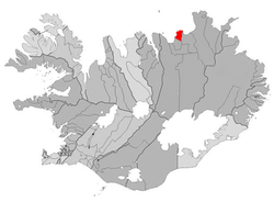
Tjörnes is a municipality in northern Iceland . It is located in the Norðurland eystra region . On January 1, 2019, the community had 55 residents.
geography
The municipality occupies most of the Tjörnes peninsula between Öxarfjörður in the east and Skjálfandi Bay in the west. The municipality is enclosed to the south by the municipality of Norðuring and to the north by the Atlantic.
The next larger settlement is Húsavík .
history
An incorporation in Húsavík was rejected in a referendum on October 8, 2005.
Population development
Like most areas of Iceland, with the exception of the southwest around the capital Reykjavík , Tjörnes has been affected by rural exodus. From 1997 to 2006 the population decline was 24%.
| year | Residents |
|---|---|
| December 1, 1997 | 79 |
| December 1, 2003 | 66 |
| December 1, 2004 | 64 |
| December 1, 2005 | 63 |
| December 1, 2006 | 60 |
traffic
The Norðausturvegur , road 85, circles the peninsula near the coast.
