
Tlalmanalco de Velázquez
| Tlalmanalco de Velázquez | ||
|---|---|---|
|
Coordinates: 19 ° 12 ′ N , 98 ° 48 ′ W Tlalmanalco de Velázquez on the map of Mexico
|
||
| Basic data | ||
| Country | Mexico | |
| State | México | |
| Municipio | Tlalmanalco | |
| City foundation | 1336 (founded by the Nonohualca) 1525 (Spanish foundation) |
|
| Residents | 14,786 (2010) | |
| Detailed data | ||
| height | 2400 m | |
| Post Code | 56700 | |
| prefix | 597 | |
| Website | ||
 |
||

Tlalmanalco de Velázquez is a small town with around 15,000 and the administrative seat of the Municipio Tlalmanalco with almost 50,000 inhabitants in the southeast of the Mexican state of México near the border with the state of Puebla .
location
Tlalmanalco de Velázquez lies at the foot of the volcanoes Iztaccíhuatl and Popocatépetl . Mexico City , the capital of the country, is about 50 kilometers (driving distance) to the northwest.
Population and economy
The population of the small town consists of Indians and Mestizos ; Europeans are rare. They speak Nahuatl and Spanish and live mainly from agriculture, which also includes a little cattle breeding. The city itself acts as a commercial and service center for the surrounding villages.
history
Archaeological finds show that the area dates back to 2000 BC. Was settled; from a later period (around 1000 AD) ethnic and tribal groups such as the Xochteca , Cocolca , Olmec-Xicallanca and Quiyahuizteca are known, all of which were later subjugated or driven out by the Toltecs and Chichimecs . The people of the Nonohualcas , a subgroup of the Chalcas , founded a first large settlement in 1336, which, however, was subjugated and made subject to tribute by the Aztecs under Montezuma I in 1465 . After the conquest of the Aztec Empire (1519–1521) by Hernán Cortés , the inhabitants of the central Mexican highlands offered little resistance to the Spanish conquistadors. The first European missionaries - including the Franciscan Martin de Valencia - came to the area around Tlalmanalco in the 1520s . In 1525 they built a monastery in the middle of the newly founded city called San Luis Obispo , which was given its shape that is still visible today at the end of the 16th century. In 1858, a copper smelter started operations, but it was soon shut down; in addition, smaller textile manufacturers were established.
Attractions

- The main attraction of the place is the former monastery church on the central Plaza Mayor with its dominant corner bell tower . Tower and church facade are made of plastered quarry stone masonry , the bell storey is painted reddish; the tower ends in a dome with a lantern . The apse of the single-nave interior of the church houses a carved and gilded altarpiece with so-called Solomonic columns , which is worth seeing ; further altars are on the side walls. Also worth mentioning is the simple but harmoniously designed two-storey cloister of the former monastery, whose walkways are decorated with paintings in the style of arabesques and drolleries - stooped people and animals seem to be carrying the consoles on which the belt arches of the vault rest.
- There are arcade arches to both the right and left of the church facade , with the left side functioning as an open chapel ( Capilla abierta ). This consists of a wide-spread cult room with an apse, which, however, was reserved only for priests and was not entered by the Indians; they could attend the ceremonies on the large square in front of it. The richly decorated arcades rest on bundles of pillars with imposing capitals ; The pilaster reliefs on both sides of the apse are also intricately crafted .

San Luis Obispo

Nave

Main altar

Cloister

Depiction of a goat in the cloister
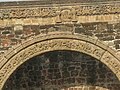
Detail of the apse framing


