Tlatlauquitepec
| Tlatlauquitepec | ||
|---|---|---|
|
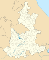
Coordinates: 19 ° 51 ′ N , 97 ° 30 ′ W Tlatlauquitepec on the map of Puebla
|
||
| Basic data | ||
| Country | Mexico | |
| State | Puebla | |
| Municipio | Tlatlauquitepec | |
| City foundation | 1524 | |
| Residents | 9047 (2010) | |
| - in the metropolitan area | 51,495 | |
| City insignia | ||
| Detailed data | ||
| height | 1930 m | |
| Post Code | 73900 | |
| Website | ||
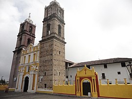
| Tlatlauquitepec - former Franciscan convent | ||
| Tlatlauquitepec - Plaza Mayor | ||
Ciudad de Tlatlauquitepec or just Tlatlauquitepec is a small town with about 10,000 inhabitants in the northeast of the Mexican state of Puebla ; the city is the administrative seat (cabecera) of Munipios of the same name . It has been recognized as Pueblo Mágico since 2012 .
Location and climate
The city of Tlatlauquitepec is located about 135 km northeast of the cities of Puebla and Tlaxcala in a valley basin surrounded by mountains at an altitude of about 1930 m . The climate is largely influenced by the Gulf of Mexico and is accordingly humid; Rain (approx. 1300 mm / year) falls predominantly in the summer half of the year.
population
| year | 2000 | 2005 | 2010 |
| Residents | 8,935 | 8,664 | 9,047 |
In the second half of the 20th century, numerous villagers immigrated from the surrounding regions. Colloquial languages are mainly Nahuatl and Spanish .
economy
The wooded region around Tlatlauquitepec is largely agricultural; Mainly maize and beans are grown . Livestock breeding also plays a not insignificant role.
history
Before the conquest by the Spaniards, the area was inhabited by members of various Indian tribes, who were subjugated by the Aztecs around 1470 and made tribute. In 1524 the Spaniards took control of the region. From the 1520s and 1530s, monks of the Franciscan order devoted themselves to the religious education of the Indian population; numerous convents were founded for this purpose .
Attractions
- The streets in the center, mostly lined with single-storey houses, are mostly laid out at right angles; at the central Plaza Mayor are the church and town hall.
- The two-towered and three-aisled monastery church of the Iglesia de Nuestra Señora de la Asunción is located on a walled square on the outskirts; it dates from the middle of the 16th century, but the bell storeys of the two almost 40 m high towers were only added in the 1830s. The central nave of the church is spanned by an artesonado ceiling.
- Surroundings
- Approx. The Santuario del Señor de Huaxtla is 5 km to the southwest . Construction of a church began in 1701, but work on it continued throughout the 19th century.
Web links
- Tlatlauquitepec - Info (inafed, Spanish)
- Tlatlauquitepec, history - photos + info (spanish)
- Tlatlauquitepec, Tourism - Photos + Info (Spanish)


