Totenkarspitze
| Totenkarspitze | ||
|---|---|---|
|
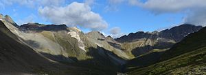
Totenkarspitze (far left) with parts of the Umbalkamm |
||
| height | 3133 m above sea level A. | |
| location | Tyrol , Austria | |
| Mountains | Panargenkamm , Venediger Group | |
| Coordinates | 46 ° 58 '50 " N , 12 ° 12' 15" E | |
|
|
||
| First ascent | L. Eisenreich, H. Finkelstein and C. Rößler (1892) | |
| Normal way | From Rotenmanntörl over the northwest ridge ( II + or III- ) | |
The Totenkarspitze is a 3133 m above sea level. A. high mountain peaks of the Panargenkamm in the Venediger group . The summit is in the north-west of East Tyrol in the municipality of St. Jakob in Defereggen . The Totenkarspitze was first climbed on August 4, 1892 by L. Eisenreich and C. Rößler and was the first summit of the Panargenkamm to be climbed.
location
The Totenkarspitze is the northernmost peak of the Panargenkamm. It lies between the Rotenmanntörl ( 2997 m above sea level ) in the north and the Keeslenke ( 3050 m above sea level ) in the southeast, whereby the Rotenmanntörl the Totenkarspitze from the Rotenmannspitze ( 3077 m above sea level ) or the Umbalkamm and the Keeslenke separates the Totenkarspitze from the Panargenspitze ( 3117 m above sea level ). The Totenkarspitze consists of the north-west or main summit and the south-east summit ( 3111 m above sea level ) and is part of the Hohe Tauern National Park . To the east of the Totenkarspitze is the head of the Dabertal valley, to the east is the Schwarzachtal.
Promotion opportunities
The normal route to the Totenkarspitze starts at Rotenmanntörl, which you can climb from the Neue Reichenberger Hütte via the Daberlenke, from the Clarahütte via the Dabertal or from the Alpengasthaus Oberhaus from the Schwarzachtal. Then the path leads partly in steep climbing over the northwest ridge to the summit ( II + or III- ). The south-east summit can be reached more easily via the south-west flank or the north-east ridge ( I ).
Individual evidence
literature
- Georg Zlöbl: The three thousand meter peaks of East Tyrol in the Hohe Tauern National Park . Verlag Grafik Zloebl, Lienz-Tristach 2007, ISBN 3-200-00428-2 .
- Willi End / Hubert Peterka : Alpine Club Leader Venediger Group . Bergverlag Rudolf Rother ; 4th edition 1994, ISBN 3-7633-1242-0 .

