
Rotenmanntörl
| Rotenmanntörl | |||
|---|---|---|---|
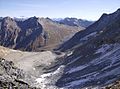
 Rotenmann rock with Totenkarspitze from the northwest |
|||
| Compass direction | southwest | east | |
| Pass height | 2997 m above sea level A. | ||
| region | East Tyrol | ||
| expansion | Marked trail | ||
| Mountains | Panargen- / Umbalkamm ( Venediger Group ) | ||
| Map (Tyrol) | |||
|
|||
| Coordinates | 46 ° 58 '54 " N , 12 ° 12' 13" E | ||

The Rotenmanntörl is a high alpine crossing ( 2997 m above sea level ) from the rear Defereggental / Schwarzachtal over to the Dabertal. The Törl is located in the core zone of the Hohe Tauern National Park in East Tyrol . Exactly in the transition (Törl) a striking, red-yellow monolith rises into the sky (Rotenmann-Fels).
location
The Rotenmanntörl lies at the intersection of the rear Reintal in South Tyrol (= Knuttental), the rear Defereggental (East Tyrol) and the rear Umbaltal (part of the Virgental , East Tyrol). It forms exactly the border between the Panargen and the Umbalkamm in the Venediger group and is not far from the Rieserferner group .
The idiosyncratic naming of this mountain cut is no coincidence. In the middle of the dark gray primary rock there is an approximately twelve meter high rock spike ( monolith ) embossed in reddish sandstone . This “red man” is a geological rarity for the area.
Via the short and brittle north-west ridge ( climbing difficulty II-, one point III- ) you reach the north-west summit of the Totenkarspitze ( 3133 m ) from Rotenmanntörl . To the northwest of the Törl lies the Rotenmannspitze ( 3077 m ), which is easy to climb .
The Rotenmanntörl is located away from the much-visited mountain trails in a lonely mountain landscape. The closest mountain huts with overnight accommodation are the Neue Reichenberger Hut ( 2586 m ), the Barmer Hut ( 2610 m ), the Clarahütte ( 2035 m ) and the Patscher Alm ( 1685 m ).
Tours
The Rotenmanntörl can be reached from
- the Clarahütte ( 2035 m ) in the Umbaltal over the side valley "Dabertal": Via the "Rudolf-Tham-Weg" through the Dabertal to the junction of the marked path no. 312. From there the path leads over glacier moraines on the east side up to Törl.
- From the Neue Reichenberger Hütte ( 2586 m ) via the "Rudolf-Tham-Weg" to the junction of the marked path no. 312. From there the path leads over glacier moraines on the east side up to the Törl.
- from the Oberen Seebachalm (at 1879 m , in the rear Defereggental , between the Jagdhausalm and the Oberhausalm) via the marked trail no. 312: The path runs from the Seebachalm in a north-westerly direction through alpine meadows; the marking stops in between at a few hundred meters above sea level , but then starts again higher up. Then a ridge edge becomes visible on the horizon, which shows the direction towards the Törl almost exactly.
- from the Jagdhausalm into the rear Schwarzachtal (= origin of the Schwarzach ), then turn right there, over the Schwarze Törl ( 2941 m ), later on to trail no.312: This path is shown on hiking maps, but not in reality marked. Here, however, you can easily orientate yourself on a field cross ( Törler Kreuz , Lage ) set up around 300 meters above the valley floor of the Schwarzach Valley and visible from afar and a small lake at almost 2600 m altitude. The last 150 meters in altitude to the Schwarzen Törl (final slope) consist on the west side of a steep scree slope with brittle flanks; the section from the transition (Schwarzes Törl) to path no. 312 below the east side of the Rotenmanntörl is then no longer difficult.
Ascent and descent
The last 70 meters in altitude on the west side (Seebachalm side) of the Rotenmanntörl are steep, but accessible. There is a risk of falling rocks from the summit of the Totenkarspitze, so you should keep to the left as possible on the steep final slope under the Törl.
The last 50 meters in altitude on the east side of Rotenmanntörl (Dabertal side) have been officially closed since a landslide in 2008. There is only a warning sign ("closed") at the junction of path no. 312 in Dabertal. There are no warning signs on the west side, ie coming from the Obere Seebachalm. Because of the steepness resulting from the landslide and the loose subsoil on the east side of Rotenmanntörl, there is an acute risk of falling along the path marked in the hiking maps. A descent from Rotenmanntörl in a west-east direction is therefore urgently not recommended at the moment.
Plaque
Near the junction from path No. 312 in the Dabertal (a few hundred meters north of it) there is a memorial plaque commemorating 9-year-old Jakub Tejkl from the Czech Republic . He died of exhaustion on October 28, 2002 on his return from a mountain tour with his father (from the Keeseck summit , 3173 m ) after an emergency bivouac . The case had caused a sensation in Tyrol at the time (“How can you take a 9-year-old at the end of October to a 3000m mountain peak that is then already completely snow-covered and difficult to climb?”) And ended with the father being sentenced to suspended sentence for negligent homicide .
Summit in the area
- Totenkarspitze ( 3133 m )
- Panargenspitze ( 3117 m )
- Keeseck ( 3173 m )
- Rotenmannspitze ( 3077 m )
- Rotenmannkopf ( 3125 m )
- Reichenberger Peak ( 3030 m )
photos

Rotenmanntörl from the east

Rotenmanntörl west side from the south
View from Rotenmanntörl on the east side descent with Reichenbergerspitze ( 3030 m ) in the middle left in the background

Jagdhausalm from the west ascent to Rotenmanntörl

Dreiherrnspitze ( 3499 m ) from Rotenmanntörl


Web links
Individual evidence
- ^ Hubert Peterka , Willi End : Venediger group . Alpine Club Guide. 3. Edition. Bergverlag Rother, Munich 1982, ISBN 3-7633-1242-0 , p. 500 (margin no. 1247).
- ^ Hubert Peterka , Willi End : Venediger group . Alpine Club Guide. 3. Edition. Bergverlag Rother , Munich 1982, ISBN 3-7633-1242-0 , p. 488 (margin no. 1181).
- ↑ ÖK50
- ^ Annual report 2002 of the Prägraten mountain rescue service (regarding the death of 9-year-old Jakub Tejkl), pages 15–18