Treptower Bridge (Landwehr Canal)
Coordinates: 52 ° 29 ′ 41 ″ N , 13 ° 26 ′ 49 ″ E
| Treptower Bridge | ||
|---|---|---|
| use | Road traffic (restricted) | |
| Convicted | Treptower Strasse | |
| Crossing of | Landwehr Canal | |
| place | Berlin-Kreuzberg | |
| construction | symmetrical three-arched brick bridge | |
| overall length | 35 m | |
| width | approx. 10.50 m | |
| Longest span | approx. 12 m | |
| Clear height | 4.35 | |
| start of building | 1880 | |
| completion | 1882 (1852?) (1894?) | |
| planner | Johann Jakob Helfft | |
| location | ||
|
|
||
The Treptower Bridge leads over the flood ditch of the Landwehr Canal to the southern tip of Lohmühleninsel and connects Kreuzberg with Alt-Treptow . The landmarked road bridge is no longer used due to the park-like character of the Lohmühleninsel. It is one of the oldest preserved brick arch bridges in Berlin.
The Treptower Bridge on the Landwehr Canal is not to be confused with the Treptower Bridge on the Neukölln Shipping Canal.
history

Around 1709 there was a previous bridge under the name Köpenicker Bridge , "over which the city of Viehtrift goes" . During the expansion of the former Landwehr ditch into a navigable canal, a new stone bridge for the road to Treptow was built in 1852 based on designs by Johann Jakob Helfft (around 1802–1869) (according to other sources 1880–1882 or 1894) and was given this destination name. It is a brick arch bridge with three equally wide openings , which is sparsely decorated with red clinker bricks and yellow clinker strips . The brick foundations of the bridge are in the trench bed. The fence-like masonry bridge railing forms another ornament.
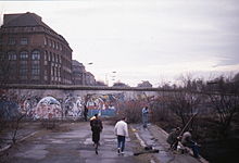
After the Second World War , this bridge was not only the border between the former city districts, but also the border between the American and Soviet sectors of Berlin , as laid down in the Treaty of Yalta . When the Berlin Wall was built by the GDR government in 1961 , the corresponding concrete segments came directly next to the Treptower Bridge.
In 1993, after the removal of the wall segments, the then Kreuzberg district had the bridge completely renovated and cleaned.
In the vicinity of the bridge

Since the opening of the Wall, the Berlin Wall Trail has passed through the Silesian Bush directly at the southern end of the bridge. - In 2007/2008, the landscape architects Heine carried out extensive redesign work on the island and the network of paths in three construction phases, some of which was financed by public funds. The bridge slab was covered with natural stones laid in scaled arches . The ends of the bridge open on both sides in an inviting funnel shape to the greened banks.
The name Treptower Bridge often leads to misunderstandings among non-Berlin visitors because it is colloquially referred to as the Elsenbrücke complex or Oberspreebrücke / Parkwegbrücke .
literature
- Nikolai Rosskamm, Sebastian Seelig (Ed.): Urban Lock. Northern Lohmühleninsel. Results of a design workshop in 2006 (= gray series , no. 6.)
Web links
Individual evidence
- ↑ Eckhard Thiemann, Dieter Deszyk, Peter Horst Metzing: Berlin and its bridges. Jaron Verlag, Berlin 2003, ISBN 3-89773-073-1 , p. 148.
- ↑ Kathrin Chod: Treptower Bridge . In: Hans-Jürgen Mende , Kurt Wernicke (Hrsg.): Berliner Bezirkslexikon, Friedrichshain-Kreuzberg . Luisenstadt educational association . Haude and Spener / Edition Luisenstadt, Berlin 2002, ISBN 3-89542-122-7 ( luise-berlin.de - files of the Royal Secret State Archives - as of October 7, 2009).
- ↑ Entry in the Berlin State Monument List
- ^ View of the Wall in 1983 on the Treptower Bridge. In: Stern Photo Community; Retrieved January 5, 2010
- ↑ Homepage LA Heine ( Memento of the original from January 8, 2010 in the Internet Archive ) Info: The archive link was inserted automatically and has not yet been checked. Please check the original and archive link according to the instructions and then remove this notice. with references and walks offered; Retrieved January 5, 2010
- ↑ Reconstruction plans for Lohmühleninsel and the network of paths (PDF), accessed on January 4, 2010
- ^ Image on "Panoramio", accessed on January 6, 2010


