
Upper Freiarchen Bridge
Coordinates: 52 ° 29 ′ 48 ″ N , 13 ° 27 ′ 0 ″ E
| Upper Freiarchen Bridge | ||
|---|---|---|
 |
||
| use | Road traffic | |
| Crossing of |
Landwehr Canal , bypassing the flood ditch |
|
| place | Berlin-Kreuzberg | |
| construction | Iron girder bridge with a steel bridge panel above, stone-clad abutments with decorative elements |
|
| overall length | 50 m | |
| width | 30 m | |
| start of building | 1893 | |
| completion | 1894 | |
| planner | Stahn, Zander (s) | |
| location | ||
|
||

The Obere Freiarchenbrücke is a road bridge over the flood ditch , which runs parallel to the Landwehr Canal to the south , on the border of the districts of Berlin-Kreuzberg and Berlin-Alt-Treptow . The building was built between 1893 and 1894 and is now a listed building.
Naming and location
The name of the bridge means Obere Freischleusenbrücke or Obere Umflutkanalbrücke (see Umflut ), because the word arche (Latin: arca ) was also used for lock in the German language . The lock located here compensates for a height difference of around 20 cm between the flood ditch - as the first eastern section of the waterway is called - and the Spree . The addition "Upper" shows that there is a counterpart, a Lower Frearch Bridge .
Together with the neighboring Schlesische Brücke , the Obere Freiarchenbrücke in the street in front of the Schlesisches Tor / Puschkinallee connects the districts of Berlin-Kreuzberg and Berlin-Alt-Treptow . The Freiarchenbrücke still belongs completely to Kreuzberg. It is located on the same waterway kilometer 10.57 as the Schlesische Brücke. Since the flood ditch is not used for shipping, there is only a narrow water flow, 7 m wide, centrally under the bridge. A headroom is therefore not specified.
history
The builder of the Upper Freiarchen Bridge was the city of Berlin , which in 1876 had taken over responsibility for all bridges in Berlin from the Prussian state. In 1842 there was a wooden predecessor structure. Only with the expansion of the former sheep ditch into a navigable canal was a more stable structure necessary to regulate the water level. The magistrate had announced a competition that the architect Otto Stahn had won together with the engineer Zanders. The construction company Belter & Schneevogl carried out the design.
During the division of the city, the bridge was directly on the sector border in West Berlin .

Flutgraben, Obere Freiarchenbrücke and Berlin Wall , 1986

Obere Freiarchenbrücke, 1987
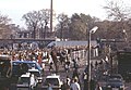
Obere Freiarchenbrücke after the opening of the wall, November 11, 1989


architecture

The bridge structure rests on large abutments that are completely clad with bricks and have terracotta decorations on all four broad sides . The relief panels are symmetrically decorated with floral tendrils, in the middle two putti hold a coat of arms. Wrought iron railings delimit the bridge plate on both sides. In a decorative ornament, the spelling of the time Ober Freiarchen Brücke can be read in Gothic script. The pavement board is covered with small pavement .
The length of the bridge is about 50 m, the width 30 m. The lane width can be specified as 17 m, with wide footpaths on both sides.
Web links
- Upper Freiarchen Bridge on Structurae
- Upper Freiarchen Bridge . In: District lexicon of the Luisenstädtischer Bildungsverein
- Where Kreuzberg once ended . Video on Youtube about the Silesian and Obere Freiarchenbrücke (9:58 minutes)
Individual evidence
- ↑ Cultural monument Obere Freiarchenbrücke
- ↑ Map of the Landwehr Canal , here the Schlesische Brücke is marked, southeast of it is the Obere Freiarchenbrücke (here without a name).
- ↑ or possibly Zander, Willy . In: Berliner Adreßbuch , 1905, Part I, p. 2370. “Government Building Inspector”.
- ↑ Belter . In: New address book for Berlin and its suburbs , 1896, I, p. 71 (Maschinenbauanstalt, Fabr. F. Eis. Brücken-, Dach- und Bauconstr .; Pankstrasse [owner Aug. Belter and Otto Schneevogl]).
- ↑ The bridge dimensions were measured with the tools of the Senate map.