
Trinidad (Cuba)
| Villa de la Santísima Trinidad | ||
|---|---|---|
|
Coordinates: 21 ° 48 ′ N , 79 ° 59 ′ W Villa de la Santísima Trinidad on the map of Cuba
|
||
| Basic data | ||
| Country |
|
|
| Residents | 74,739 (2012) | |
| City insignia | ||
 |
||
| Detailed data | ||
| surface | 1155 km 2 | |
| Population density | 65 people / km 2 | |
_03.jpg) |
||
 |
||

_02.jpg)
Trinidad is a city and a municipality in the province of Sancti Spíritus on the central south coast of Cuba . 74,739 people (2012 census) live in the municipality on an area of 1166.74 km². This corresponds to a population density of 64 inhabitants per km².
history
Trinidad was founded in 1514 by the Spanish conqueror Diego Velázquez de Cuéllar under the name "Villa de la Santísima Trinidad". It was the third Spanish settlement after Baracoa and Bayamo . In 1519 the conquistadors under Hernán Cortés of Trinidad started their conquest expeditions to Mexico . In Trinidad, it was initially hoped to find gold in the nearby rivers. However, when the plans proved unrealistic, smuggling was the main survival well into the 18th century.
Trinidad owes its rise to a prosperous city to sugar and the associated slave trade. Until the middle of the 19th century, Trinidad was one of the most important sugar cities in Cuba. Tobacco cultivation and cattle breeding were also successful, so that between 1780 and 1830 the population quadrupled. Even three pillages by pirates could not stop the growth of Trinidad into the third largest city in Cuba. The Valle de los Ingenios developed into the largest sugar cane plantations , where the Iznaga family of planters began building sugar mills in 1830. In 1846 sugar production peaked at 7700 tons. During his research trip through the American tropics (1799–1804), Alexander von Humboldt stayed in Trinidad for a short time in 1801.
When sugar production from sugar cane decreased drastically with the increased cultivation of sugar beet in Europe at the end of the 19th century , the city's blooming phase ended. Trinidad lost its supremacy in the region to neighboring Cienfuegos , which in turn experienced an upswing through the development of new traffic routes and the expansion of its port. Trinidad sank into insignificance, but was able to retain its medieval streetscape and partly also the magnificent buildings around the Plaza Major. It was not until the 1950s that Trinidad experienced an upswing thanks to the new road connections to Cienfuegos and Sancti Spíritus . In the first half of the 1960s, the Sierra de Escambray, a few kilometers north of the city, was a retreat for counterrevolutionary groups. Since 1988 the city has in common with the 20 km outside past sugar cane plantations of Valle de los Ingenios World Heritage of UNESCO .
Attractions
One of the biggest tourist attractions is the Plaza Mayor, whose flair is still reminiscent of the colonial times . All major museums can be found around this square, such as the Museo Romántico in the former Palacio Brunet and the architecture museum. The colonial center with a diameter of about 600 m has largely been preserved, most of the houses are inhabited.
Excursion destinations near Trinidad include the Topes de Collantes National Park in the Sierra de Escambray , the sugar cane valley Valle de los Ingenios and the Ancón peninsula with sandy beaches and snorkeling opportunities.

View from the bell tower of the former Franciscan monastery
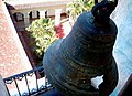
View from the bell tower of the former Franciscan monastery

Holy Trinity Church in Plaza Mayor

Holy Trinity Church (interior view)
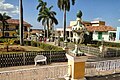
Plaza Mayor


sons and daughters of the town
- Julio Cueva (1897–1975), trumpeter and composer
- Carlos Díaz (1930–2002), singer
- Alain Pérez (* 1977), bassist, composer, music producer
Web links
- Entry on the UNESCO World Heritage Center website ( English and French ).
- Orlando Martínez Rodríguez and Teresa Turiño López: La Trinidad de Cuba: Medio milenio de venturas y desventuras. In: Contribuciones a las Ciencias Sociales from November 2011 (Spanish)
literature
- Cuba . Karl Baedeker GmbH, Ostfildern 1999/2000, ISBN 3-89525-476-2
Individual evidence
- ↑ Census 2012 (PDF; 257 kB) , ONE
Cabaiguán | Fomento | Jatibonico | La Sierpe | Sancti Spíritus | Taguasco | Trinidad | Yaguajay

Cultural heritage: Old town and fortifications of Havana (1982) | Trinidad and the Valle de los Ingenios (1988) | Castillo de San Pedro de la Roca (1997) | Valle de Viñales Cultural Landscape (1999) | Archaeological landscape of the first coffee plantations in southeastern Cuba (2000) | Historic city center of Cienfuegos (2005) | Historic center of Camagüey (2008)
Natural heritage: Desembarco del Granma National Park (1999) | Alexander von Humboldt National Park (2001)