Tsikoane
| Tsikoane | ||
|---|---|---|
|
|
||
| Coordinates | 28 ° 54 ′ S , 28 ° 0 ′ E | |
| Basic data | ||
| Country | Lesotho | |
| Leribe | ||
| ISO 3166-2 | LS-C | |
| height | 1647 m | |
|
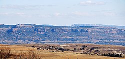
View of the Tsikoane Plateau from the east
|
||
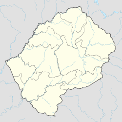
Tsikoane is a place in the district of Leribe in Lesotho in southern Africa .
geography
Tsikoane is located between Hlotse and Maputsoe not far from the border between Lesotho and South Africa , which is formed here by the Caledon . To the south rises the Tsikoane plateau made of sandstone , which is up to 1890 meters above sea level.
Economy and Infrastructure
Tsikoane is agriculturally oriented. There is an Anglican mission station that has existed since the 1880s . The place is south of the Main North One highway , also A1, which leads from Maseru via Hlotse to Butha-Buthe and Mokhotlong .
Others
The place is known for the fossilized footprints of a dinosaur on the Tsikoane Plateau .
Personalities
- Moeketsi Majoro (* 1961), politician, born in Tsikoane
Individual evidence
- ^ Map of Lesotho, 1: 250,000, Lesotho Government, 1978
- ^ Scott Rosenberg, Richard F. Weisfelder: Historical Dictionary of Lesotho. Scarecrow Press, Lanham, Maryland / Oxford 2013, ISBN 978-0-8108-7982-9 , p. 40. Excerpts from books.google.de
- ↑ Tsikoane village dinosaur footprints. lonelyplanet.com, accessed May 4, 2020

