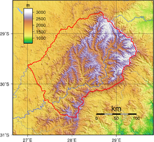
Border between Lesotho and South Africa
The border between the Kingdom of Lesotho and the Republic of South Africa is 1106 kilometers long. Since Lesotho is an enclave in South Africa, Lesotho only has this border.
geography
The lowest point of the border is on Makhaleng south of Mohale's Hoek at about 1390 meters above sea level - also the lowest point in Lesotho - and the highest point at almost 3400 meters in the Drakensberg .
The north-western border - seen from Lesotho - is formed by the Caledon / Mohokare , a tributary of the Oranje / Senqu . Part of the southwest border runs along the Makhaleng, the Oranje and the Tele. To the east the border is close to the highest mountains in southern Africa. The only border crossing there is the Sani Pass . The border lies in the south and east on the main watershed between the Indian and Atlantic Oceans , in the north on the watershed of Oranje and Vaal .
All ten districts of Lesotho border on South Africa. The South African provinces Free State (Free State), KwaZulu-Natal and Eastern Cape (Eastern Cape) bordering Lesotho.
Border crossings
There are 13 road crossings between the two states. The Maseru Bridge rail border crossing point is just a few meters north of the road crossing. The transition Bushman's Nek / Ngoangoana ( 29 ° 53 '5.6 " S , 29 ° 9' 11.5" O ) is in cross-border uKhahlamba-Drakensberg Park ( KwaZulu-Natal / Qacha's Nek ) and may only be crossed on foot.
List of road crossings
| designation | Road in South Africa | Street in Lesotho | opening hours | Coordinates |
|---|---|---|---|---|
| Maseru Bridge | N8 | A2 | Midnight | 29 ° 17 ′ 52.8 ″ S , 27 ° 27 ′ 16.6 ″ E |
| Peka Bridge | 8 am to 4 pm | 29 ° 56 ′ 42 " S , 27 ° 44 ′ 3.8" E | ||
| Ficksburg Bridge / Maputsoe | Midnight | 28 ° 53 '2 " S , 27 ° 53' 25.1" E | ||
| Caledonspoort | 6 a.m. to 10 p.m. | 28 ° 41 ′ 41.3 " S , 28 ° 14 ′ 2" E | ||
| Montansa Pass | 8 am to 4 pm | 28 ° 35 '24.7 " S , 28 ° 40' 57.4" E | ||
| Sani Pass | A14 | 8 am to 4 pm | 29 ° 35 ′ 4.9 ″ S , 29 ° 17 ′ 10.7 ″ E | |
| Ramatšeliso's Gate | 8 am to 4 pm | 30 ° 3 ′ 0.7 ″ S , 28 ° 56 ′ 2 ″ E | ||
| Qacha's Nek | A4 | 6 a.m. to 10 p.m. | 30 ° 7 ′ 46.9 ″ S , 28 ° 41 ′ 8.2 ″ E | |
| Ongeluksnek | 8 am to 4 pm | 30 ° 20 '17.9 " S , 28 ° 15' 6.8" E | ||
| Tele Bridge | R393 | A24 | 6 a.m. to 10 p.m. | 30 ° 25 '54.8 " S , 27 ° 34' 2.3" O |
| Makhaleng Bridge | A23 | 8 am to 4 pm | 30 ° 9 ′ 50.8 ″ S , 27 ° 23 ′ 58.6 ″ E | |
| Sephapho's Gate | 8 am to 4 pm | 29 ° 56 '51.4 " S , 27 ° 11' 57.5" E | ||
| Van Rooyen's Gate | R702 | A20 | 6 a.m. to 10 p.m. | 29 ° 45 '21.6 " S , 27 ° 6" 32.8 " O |
history
The current border was established in the 19th century and was established in the Treaty of Aliwal North (Convention of Aliwal North) between the Boers and the British in 1869 as the new colonial power in Basutoland . As a result of the Senekal War and the Seqiti War between Buren and Basotho , the western border of what was then Basutoland had shifted significantly to the east, while the other borders were determined along the former settlement borders.
On December 9, 1982, special forces of the South African Defense Force flew over the unsecured border and murdered 42 people in Maseru, including numerous South African refugees (see South African attack on Lesotho 1982 ). Members of the Lesotho Liberation Army had previously crossed the border to carry out attacks.
In the weeks leading up to January 20, 1986, South Africa closed all border crossings to Lesotho, blocking the flow of goods to Lesotho. As a result, the Lesotho military launched a coup against Leabua Jonathan's government . The South African government then lifted the blockade.
Web links
- Lesotho-South Africa Border Crossings at www.drivesouthafrica.co.za (English)
Individual evidence
- ^ CIA Factbook , accessed August 5, 2015
- ↑ Lesotho-South Africa Border Crossings at www.drivesouthafrica.co.za (English), accessed on August 5, 2015
- ↑ Khabele Matlosa, Neville W. Pule: Civil-military relations in Lesotho, 1966–1998. Problems and prospects. oldsite.issafrica.org (PDF), accessed on April 13, 2018


