
Qacha's Nek District
| map | |
|---|---|
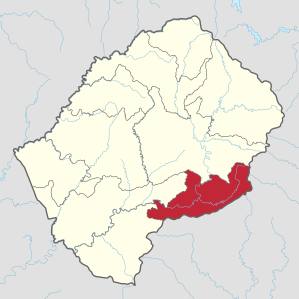  Location of the Qacha's-Nek district in Lesotho |
|
| Basic data | |
| Administrative city | Qacha's Nek |
| surface | 2349 km² |
| population | 74,566 (as of 2016) |
| Population density | 32 inhabitants / km² |
| ISO 3166-2 |
LS-H
|
| Telephone code | +266 |

The district of Qacha's Nek [ ˈ! Ɑtʃɑs nɛk ] is one of ten districts of the Kingdom of Lesotho in southern Africa .
geography
The district is located in southeast Lesotho. It is named after its capital, Qacha's Nek . The city in turn is named after a son of Phuthi language - chief Moorosi, Ncatya. Nek comes from Afrikaans and is called mountain pass here.
The size of the district of Qacha's Nek is 2349 km², its population 74,566 (as of 2016). This makes it one of the sparsely populated districts of Lesotho. It also has the lowest population of any district.
See also: Data from the districts of Lesotho
The district of Qacha's Nek is located in the mountainous part of Lesotho.
It borders on the Quthing District to the west, the Mohale's Hoek district to the northwest and the Thaba-Tseka district to the northeast . In the east and south the district borders on the South African provinces of KwaZulu-Natal and Eastern Cape , to which there is a border crossing at the place Ramatšeliso's Gate. Until its dissolution in 1994, the homeland Transkei bordered the Qacha's-Nek district in the south .
climate
Due to the proximity to the Indian Ocean and the clouds that move from there almost daily, the climate in the Qacha's-Nek district is much more moderate and humid than in all other districts of Lesotho.
Localities
- Qacha's Nek, administrative headquarters and hospital, founded in 1888
- Tsoelike , with a planned dam as part of the Lesotho Highland Water Project
- Sehonghong
- Sehlabathebe (German: Schild-Plateau ) with national park
Community Councils
The Community Councils are Khomo-Phatsoa, Letloepe, Maseepho, Matebeng, Mosenekeng, Patlong, Ramatšeliso, Ratšoleli, Thaba-Khubelu, Thaba-Litšoene and White Hill.
The Sehlabathebe National Park
The Sehlabathebe National Park was established in 1969th It is the only officially recognized national park in Lesotho and part of the cross-border uKhahlamba-Drakensberg Park , which is a UNESCO World Heritage Site. The area is 65 km² and is located in the southeastern tip of Lesotho at an altitude of around 2450 meters. The highest sandstone formations in southern Africa can be found there . The relatively humid climate allows for lush vegetation. Most of the deer antelopes ( Pelea capreolus ) in the country are found in the fenced-in area . A small lodge is available for visitors .
history
The district of Qacha's Nek was not settled by Basotho and Phuthi until the middle of the 19th century . Before that, only San lived in this area.
literature
- David Ambrose : The Guide to Lesotho. 2nd Edition. Winchester Press, Johannesburg / Maseru 1976, ISBN 0-620-02190-X .
Web links
Individual evidence
- ↑ 2016 Summary Key Findings. Bureau of Statistics (PDF), accessed March 17, 2018
- ↑ Statistics at statoids.com (English), accessed on December 28, 2012
Berea | Butha-Buthe | Leribe | Mafeteng | Maseru | Mohale's Hoek | Mokhotlong | Qacha's Nek | Quthing | Thaba-Tseka
Coordinates: 30 ° 0 ′ S , 28 ° 45 ′ E