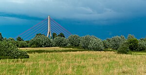
Uedesheimer Rheinbogen
|
Uedesheimer Rheinbogen
|
||
|
Uedesheimer Rheinbogen |
||
| location | North Rhine-Westphalia , Germany | |
| surface | 109 ha | |
| Identifier | NE-005 | |
| WDPA ID | 165979 | |
| Natura 2000 ID | DE4806304 | |
| FFH area | 92 ha | |
| Geographical location | 51 ° 11 ' N , 6 ° 47' E | |
|
|
||
| Setup date | 1987 | |
The Uedesheimer Rheinbogen is a green corridor on the left bank of the Rhine at the Fleher Bridge east of Grimlinghausen and north of Uedesheim , both districts of Neuss . An area of 108.95 hectares has been designated as a nature reserve since 1987 . Here is the location of the Rheinbogen waterworks . Since 2004, most of the nature reserve has also been protected as an FFH area "NSG Uedesheimer Rheinbogen".
Web links
- Nature reserve “Uedesheimer Rheinbogen” (NE-005) in the specialist information system of the State Office for Nature, Environment and Consumer Protection in North Rhine-Westphalia
- 4806-304 NSG Uedesheimer Rheinbogen. (FFH area) Profiles of the Natura 2000 areas. Published by the Federal Agency for Nature Conservation .
Individual evidence
- ^ House of Nature - Biological Station in the Rhein-Kreis Neuss eV: FFH area Uedesheimer Rheinbogen. Retrieved May 26, 2020 .
- ^ Bochumer Botanischer Verein e. V .: Excursion Neuss: NSG Uedesheimer Rheinbogen. May 3, 2014, accessed May 26, 2020 .
- ^ Uedesheimer Rheinbogen. In: natur-erleben-nrw.de. Retrieved May 26, 2020 .
- ^ Stadtwerke Neuss: extraction & supply - drinking water from the region, for the region. Retrieved May 26, 2020 .


