
Ilvericher Altrheinschlinge
|
NSG Ilvericher Altrheinschlinge
|
||
 |
||
| location | Meerbusch , North Rhine-Westphalia , Germany | |
| surface | 3.081 km² | |
| Identifier | NE-002 | |
| WDPA ID | 163850 | |
| Natura 2000 ID | DE-4706-301 | |
| Geographical location | 51 ° 17 ′ N , 6 ° 40 ′ E | |
|
||
| Setup date | 1981 | |
| administration | Rhine district of Neuss | |

The Ilvericher Altrheinschlinge (sometimes also called Ilvericher Bruch or Das Meer ) is a silted-up arm of the Rhine ( Altrhein ) near Meerbusch , named after the neighboring Ilverich district .
The Ilvericher loop is the only completely closed oxbow loop with unchanged geomorphology on the Lower Rhine. The floodplain landscape with its marsh waters , extensively used wet meadows and arable land , rain areas and small floodplain and swamp forest areas and the rich fauna and flora that live in them is an official nature reserve (No. NE-002 ) and Natura2000 / FFH area (No. DE-4706 -301 ), embedded in the extensive Rheinaue landscape protection area . It is considered to be one of the most valuable nature reserves in the Lower Rhine region .
Location and geology
The 200 to 500 meter wide loop is to the left of today's course of the Rhine. In the west it borders on the Meerbusch districts (from south to north clockwise) Büderich , Strümp , Ilverich and Langst-Kierst . Surrounded by the loop is an area with arable land, a few individual farms and the Düsseldorf-Nord sewage treatment plant .
The loop, formerly the floodplain of the Rhine during high water , is now separated from the Rhine by a dike . The area should only be used as a controllable retention area during extreme floods . The area was last flooded on January 16, 1920 after a dike breached. Despite the separation from the Rhine, the water level in the still waters in the rupture is subject to fluctuations - albeit only minor ones - caused by the fact that when the Rhine floods the high groundwater level rises again, pushes it up into the open water areas and lets them overflow the banks.
The waters in the area of the Altrheinschlinge are fed by several small rivers, the largest being the Mühlenbach ( coming from Haus Meer , where it used to drive a water mill), the Kringsgraben and the Strempe (coming from Strümp).
Geologically, the loop lies in the Cologne Bay on a terrace in the Middle Lower Rhine Plain . The loop was formed around 11,000 years ago, at the beginning of the Holocene , i.e. the warming after the last ice age. At this time the Rhine turned into a strongly meandering river with many meander loops. About 7,000 years ago the Rhine broke through the narrow point, the loop was a tributary from here, which about 3,000 years ago, in the Middle Holocene , increasingly silted up, became the “dead arm” (still water) and finally a fen .
The resulting wetland ( Lower Rhine Mâr or Mêr ) was locally called "The Sea" . The name of the adjoining Haus Meer and ultimately the city of Meerbusch is derived from this.
In the area of the sling can be found as a witness to the last ice age drift blocks from lignite quartzite , as a natural monument are protected.
Flora and fauna
The landscape in the area of the loop is a mix of
- old alluvial forest remnants and swamp forests (Strümper Bruch, Ilvericher Bruch, Das Meer, ...) made of alder , ash and willow
- open, moist fallow land and extensively used wet grassland as wetlands , as well as semi-dry grasslands and sage - and oat - hay meadows in the area of the dike, traversed by Rainen and avenues of willows , poplars and other trees and shrubs
- nutrient-rich waters and swamps with reeds typical for floodplains made of cane grass , reeds , swamp and slender sedge
- Tall herbaceous corridors and river reporting corridors made from bank pioneer plants ( Association Chenopodion rubri )
In addition to plants, the area also offers protection and space for many rare or threatened animal species:
- Breeding, feeding and resting area for numerous rare and endangered wading and meadow bird species ( common snipe , marsh harrier , lapwing , meadow pipit , whinchat , wagtail , water rail , teal , nightingale , kingfisher , little grebe , oriole , ...); important link in the corridor between the bird protection areas of the Lower Lower Rhine in the north and Schwalm-Nette-Platte in the west.
- Insects (including dark blue ant blue , black and blue bog blue , ...)
- Amphibians ( crested newt , mountain newt and pond newt , ...) and fish ( wolffish , mud whip , ...)
- Bats ( great and small noctule bat , ...)

Information board
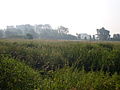
View over reed and meadows to the Ilvericher Bruch
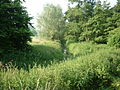
Strümper break with the Kringsgraben
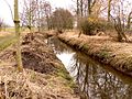
Ditch near the Rhine

.JPG)
.JPG)

Human use and interference

The central, not protected area of the loop is characterized by cultivated arable land; The Düsseldorf-Nord sewage treatment plant is also located here . The agricultural farm roads, which in some places also cross the loop itself, as well as the paths in the area of the dike are used intensively by cyclists, walkers, joggers and walkers for local recreation. Some pedestrian paths lead into the protected areas and allow nature exploration and observation.
Special effort to maintain and protect the valuable area had to be made in the context of the Rhine crossing of the A44 . Since the planned route to close the gap ran eastwards from the Meerbusch motorway junction across the protected area, the construction was very controversial for a long time. First of all, a complete tunneling under (including the Rhine) was considered; For cost reasons, however, a decision was made in favor of a combined solution of two tunnels and one bridge, the airport bridge . The tunnel construction in the area of the old arm turned out to be very complex because of the high groundwater level; a watertight basin (similar to a dry dock for ships) had to be created with sheet pile walls , in which the actual tunnel structure was then built.
literature
- aqua terra, Institute for Applied Ecology (publisher): Biotopmanagementplan Ilvericher Rheinschlinge , Westf. Vereinsdruckerei, Münster 1993.
Web links
Individual evidence
- ↑ World Database on Protected Areas - NSG Ilvericher Altrheinschlinge (English)
- ↑ a b c d e Natura 2000 area “Ilvericher Altrheinschlinge” in the specialist information system of the State Office for Nature, Environment and Consumer Protection in North Rhine-Westphalia
- ^ "Ilvericher Altrheinschlinge" nature reserve (NE-002) in the specialist information system of the State Office for Nature, Environment and Consumer Protection in North Rhine-Westphalia , accessed on March 7, 2017.
- ↑ a b c Information board on the Ilvericher Altrheinschlinge nature reserve and the Rheinaue landscape protection area near the Düsseldorf-Nord sewage treatment plant
- ↑ Hiking trail through the Ilverich Altrheinschlinge. House of Nature - Biological Station in the Rhein-Kreis Neuss eV, accessed on March 7, 2017 .
- ↑ Flood protection concept of the state of North Rhine-Westphalia ( ( page no longer available , search in web archives: online at www.nr-feldmann.de as PDF ))
- ↑ Ilverich. Dirk Tobien, accessed March 7, 2017 (private website).
- ↑ The origin of the Ilverich Altrheinschlinge. (No longer available online.) City of Meerbusch, archived from the original on March 8, 2017 ; accessed on March 7, 2017 . Info: The archive link was inserted automatically and has not yet been checked. Please check the original and archive link according to the instructions and then remove this notice.
- ↑ Brown coal quartzite natural monument. (No longer available online.) City of Meerbusch, archived from the original on March 8, 2017 ; accessed on March 7, 2017 . Info: The archive link was inserted automatically and has not yet been checked. Please check the original and archive link according to the instructions and then remove this notice.
- ^ Ilverich Rhine loop. (No longer available online.) In: Niederrhein Naturparks & Naturschauplätze. Niederrheinportal Kuhpfad, archived from the original on March 8, 2017 ; Retrieved March 7, 2017 (private website). Info: The archive link was inserted automatically and has not yet been checked. Please check the original and archive link according to the instructions and then remove this notice.
- ↑ Airport bridge . Dirk Tobien, accessed March 7, 2017 (private website).

Oil Gang Island (001) | Ilvericher Altrheinschlinge (002) | Zonser Grind (003) | Wahler Berg, Hannepützheide and Martinsee (004) | Uedesheimer Rheinbogen (005) | The Spey (006) | The Buersbach (007) | The Meerbusch (008) | Horse Broich (009) | Quartzite dome Liedberg (010) | At the black bridge (012) | Rheinaue Zons-Rheinfeld and Altrheinschlinge Zons (013) | Knechtsteden forest nature reserve (014) | Balgheimer See (015)