
Buersbach
|
Buersbach der / die Bu (e) rs (bach) , also Die Burs Bach , locally also Striebruchsbach and Oelvebach |
||
.JPG) Buersbach in the Feldmark near Ossum |
||
| Data | ||
| Water code | DE : 27552 | |
| location | Urban areas of northern Meerbusch ( Strümp , Ossum , Lank-Latum ) and southeastern Krefeld ( Gellep-Stratum , Linn , Uerdingen ) | |
| River system | Rhine | |
| Drain over | Rhine → North Sea | |
| River basin district | Rhine river basin district (sub-catchment area Rheingraben North ) | |
| source | near house Hamm near Strümp 51 ° 17 ′ 14 ″ N , 6 ° 38 ′ 26 ″ E |
|
| Source height | approx. 34 m above sea level NHN | |
| muzzle |
Rhine (in the Rheinhafen Krefeld ) Coordinates: 51 ° 20 ′ 7 ″ N , 6 ° 40 ′ 52 ″ E 51 ° 20 ′ 7 ″ N , 6 ° 40 ′ 52 ″ E |
|
| Mouth height | approx. 25 m above sea level NHN | |
| Height difference | approx. 9 m | |
| Bottom slope | approx. 0.76 ‰ | |
| length | 11.9 km | |
| Catchment area | 51.721 km² | |
| Left tributaries | Bösinghovener Bach, Stratumer Buschgraben, Linner Mühlenbach | |
The Buersbach (pronounced [ 'buːɐs.baχ ], also called Die Burs Bach [sic!]) Is a brook that flows into the Lower Rhine from the left near Krefeld - Uerdingen . From its source, it stretches over a length of more than 10 kilometers through the districts of the cities of Meerbusch and Krefeld.
Part of the course of the stream with its bank areas forms a nature reserve of the same name.
Names
The name Buersbach is derived from the noble family von Buer (high German farmer ), who owned the Latum house with the associated lands in the 17th century . As with the name-giving place Buer , the e in Buersbach is a stretching e . A spelling as Bürsbach is therefore wrong. However, the e is sometimes left out (alternative spelling : Bursbach ).
From [des / der] Bauer Bach , in Lower Franconia [de] Buers Bach , over time it became [de] Buersbach or, colloquially, just [de] Buers . Since the low-Franconian the definite article de both male can also be female, the short form was de Buers probably by mistake during the transmission into high German as grammatically feminine gender construed (feminine) from the Buers [brook] has been the Buers or the Burs . The female products which is sometimes maintained even when the male base word -bach of the compound word is co-written and thus highly language would apply its sex. In this way, the linguistically incorrect terms Die Buersbach and Die Burs Bach - even used by official bodies - arose . Is brought to a head this linguistic aberration, sometimes taking on the article which in turn is seen as an integral part of the name (Composition with so-called Depp blank ), the then a second article the is preceded in grammatical function ( of the Burs Bach or of the Buersbach ).
Course and morphology of the water
The stream begins as a small, here still nameless drainage ditch near Haus Hamm in the north-west of Strümp . The ditch passes under the A 44 directly at the Meerbusch motorway junction . The stream was relocated when the motorway was being built. From here it runs to Schloss Pesch , through the forest Mr. Busch , south on House Grip forest and Ossum over, where he met with that of Bösinghoven coming Bösinghovener Bach combined. From here the Buersbach runs east to Haus Latum and along the north-western outskirts of Lank-Latum, where it is also called Striebruchsbach . The Bursbach, here called Striebruchsbach, branches off at a bifurcation between the Lank-Latum and Gellep-Stratum . Most of the water flows westward over the Stratumer Buschgraben into the Latumer Bruch nature reserve . After crossing 2 old stream channels, the stream runs in a northerly direction and is called Lohbruchgraben here. It flows into the outer moat of Linn Castle and is called Linner Mühlenbach here. A subset flows off towards the north and is also called Oelvebach in the area west of Gellep . It flows through the Elt drinking water catchment area and then meets the Linner Mühlenbach to the west of the Römersee ( coming from the west through the Greiffenhorstpark from the Linner Mühlenhof ). From here the brook runs partly underground to the Krefeld-Uerdinger Osthafen , where it flows into the harbor basin via a pumping station shortly before the turning basin and thus into the Rhine .
According to the classification scheme of the EU Water Framework Directive , the Buersbach falls under the type " Small low- lying watercourses in river and river valleys " (type no. 19). The stream has only a slight gradient (less than 0.1% on average) and often carries so little water in months with little rain that it dries out at least in parts. The bed of the brook lies mostly in the area of an old river channel of the Rhine ( landscape protection area No. 4605-001: Ossum-Bösinghovener old river channel, Herrenbusch ), called Kendel on the Lower Rhine .
Nature reserve
|
The Buersbach
|
||
.JPG) |
||
| location | Meerbusch , NRW, Germany | |
| surface | 20.44 ha | |
| Identifier | NE-007 | |
| WDPA ID | 162736 | |
| Natura 2000 ID | (Part) [10] DE-4605-301 (part) | |
| Geographical location | 51 ° 19 ' N , 6 ° 41' E | |
|
||
| Sea level | from 25 m to 34 m | |
| Setup date | 1987 | |
| administration | Rhine district of Neuss | |

In the area of the middle course from Ossum to behind Latum, the brook and its banks form the nature reserve Die Buersbach ( NSG NE-007 ). The protected strip has a length of about 2.6 kilometers, an average width of almost 100 meters and a total area of just over 20 hectares.
Together with the adjacent Latumer Bruch nature reserve , the Greiffenhorstpark with the Linner Mühlengraben , the Elmt waterworks area and the Römersee , the Buersbach NSG forms an almost 300 hectare Natura 2000 / FFH area (No. DE-4605-301: Latumer Bruch with Buersbach , Stadtgraeben and waterworks ).
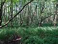
In the area of the Herrenbusch and the nature reserve in particular, the banks of the Buersbach largely consist of ecologically valuable alder - scrub forest or alluvial forest made of poplars and ( head ) willows and sometimes dense bushes and herbs. On the brook itself and on open water areas next to the brook bed there are some large sedge and reed beds .
Flora and fauna are particularly rich in species in these areas , and the Buersbach is a valuable habitat for amphibians , dragonflies and birds in particular . There are some rare species such as the crested newt , the kingfisher or the dark blue ant blue .
However, some sections of the creek in the area of arable and meadow areas used intensively for agriculture are laid out like ditches , in a moderate to poor ecological condition and are heavily polluted with nitrates due to fertilizer input. Conservationists are calling for these areas to be renatured.
Erlenbruchwald am Buersbach in the protected area of the Herrenbusch

Buersbach near the Latum house

Information board about the nature reserve
.JPG)
.JPG)
.JPG)
Remarks
- ↑ a b c For correct pronunciation, spelling and gender, please refer to the Names section .
- ↑ a b c In official maps there are contradicting information about which of the two brooks merges into the other when Buersbach and Linner Mühlenbach meet and which name the last section up to the confluence with the Rhine bears (official spelling here also Die Burs Bach ).
Individual evidence
- ↑ a b c d e f g h The District Administrator of the Rhein-Kreis Neuss (ed.): EC Water Framework Directive (WFD). Implementation timetable of the cooperation Left Rhine tributaries Neuss-Uerdingen (PE_RHE_1200) . Office for Environmental Protection, Lower Water Authority, Grevenbroich March 2012 ( full text as PDF ).
- ^ Rheingraben north. District government of Düsseldorf, accessed on May 31, 2012 .
- ↑ a b Measurement based on the German basemap 1: 5000
- ↑ a b List of maritime codes. (PDF; 292 kB) GSK3B, edition July 31, 2006. (No longer available online.) LANUV NRW, archived from the original on January 21, 2015 ; Retrieved June 4, 2012 . Info: The archive link was inserted automatically and has not yet been checked. Please check the original and archive link according to the instructions and then remove this notice.
- ↑ a b Water directory of the State Office for Nature, Environment and Consumer Protection NRW 2010 (XLS; 4.67 MB) ( Notes )
- ↑ a b Profiles of the planning units in the North Rhine-Westphalian parts of the Rhine, Weser, Ems and Maas. Surface water. Left Rhine tributaries Neuss-Uerdingen. PE_RHE_1200. (PDF; 2.3 MB) (No longer available online.) Ministry for the Environment and Nature Conservation, Agriculture and Consumer Protection of the State of North Rhine-Westphalia (MUNLV), Düsseldorf, December 2009, archived from the original on January 21, 2015 ; Retrieved May 31, 2012 . Info: The archive link was inserted automatically and has not yet been checked. Please check the original and archive link according to the instructions and then remove this notice.
- ↑ a b c nature reserve “Die Buersbach” in the specialist information system of the State Office for Nature, Environment and Consumer Protection North Rhine-Westphalia , accessed on March 3, 2017.
- ↑ Information board for the Lank home district on a memorial stone near the bridge over the Buersbach at the Lank-Latum exit towards Haus Latum and Ossum-Bösinghoven
- ^ A b Alexander Ruth: Water quality is not good at all. Rheinische Post Online, August 24, 2011, accessed June 1, 2012 .
- ↑ a b c Natura 2000 no. DE-4605-301: Latumer Bruch with Buersbach, Stadtgraeben and waterworks. Specialized information on Natura 2000 areas in NRW. Ministry for the Environment and Nature Conservation, Agriculture and Consumer Protection of the State of North Rhine-Westphalia (MUNLV), Düsseldorf, accessed on May 31, 2012 .
- ↑ Fauna-Flora-Habitat Areas (FFH). (No longer available online.) Rhein-Kreis Neuss , archived from the original on September 17, 2011 ; Retrieved June 1, 2012 . Info: The archive link was inserted automatically and has not yet been checked. Please check the original and archive link according to the instructions and then remove this notice.
- ↑ FFH area Latumer Bruch with Buersbach, city ditches and waterworks. (No longer available online.) House of Nature - Biological Station in the Rhein-Kreis Neuss eV, archived from the original on July 24, 2013 ; Retrieved June 1, 2012 . Info: The archive link was inserted automatically and has not yet been checked. Please check the original and archive link according to the instructions and then remove this notice.
- ↑ a b 27552 0 - The Burs Bach. Water network NRW, accessed on June 1, 2012 .
Web links

Oil Gang Island (001) | Ilvericher Altrheinschlinge (002) | Zonser Grind (003) | Wahler Berg, Hannepützheide and Martinsee (004) | Uedesheimer Rheinbogen (005) | The Spey (006) | The Buersbach (007) | The Meerbusch (008) | Horse Broich (009) | Quartzite dome Liedberg (010) | At the black bridge (012) | Rheinaue Zons-Rheinfeld and Altrheinschlinge Zons (013) | Knechtsteden forest nature reserve (014) | Balgheimer See (015)