
Horse Broich
|
Horse Broich (Horse Broich)
|
||
.JPG) Information board on the edge of the horse brook |
||
| location | Korschenbroich , NRW, Germany | |
| surface | 36 ha | |
| Identifier |
NE-009 Biotope : BK-4705-0058 |
|
| WDPA ID | 164997 | |
| Geographical location | 51 ° 14 ' N , 6 ° 33' E | |
|
||
| Setup date | 1987/1990 | |
| administration | Rhine district of Neuss | |

The horse Broich , sometimes horses Broich called [sic] is among conservation standing Bruchwald -region (Rhenish-Low German Broich spoken Brooch ) near Korschenbroich in Rhein-Kreis Neuss in North Rhine-Westphalia .
Location and surroundings
The Pferdsbroich lies between the Korschenbroich district of Kleinenbroich (in the south) and the neighboring towns of Kaarst - Vorst (in the east) and Willich - Schiefbahn (in the north-west). In the north, the area borders on the L 390 state road and the Neuss – Viersen railway line, which used to run alongside it and has now been dismantled , while the A 52 motorway runs a little further north .
In the west, some distance away, is the Mönchengladbach regional airfield , the planned expansion of which was rejected in 2002/2003, among other things to avoid increased disruption from aircraft noise in the Pferdebroich nature reserve.
Parallel to the L390 takes place in the northern North Channel along. To the east of the quarry ponds below, the Jüchener Bach flows past, which flows a short distance further into the North Canal.
.JPG)
In the east and south of the area there are two quarry ponds in the Kaarst Lake District , from which the company CEMEX (formerly Readymix ) extracts gravel and sand as building materials . The eastern lake, Pferdsbroichsee or Bressersee called gravel extraction (2011) was designed after a natural area and now complements the adjacent nature reserve. In addition to the large quarry pond, some smaller, shallow ponds were created as spawning waters for fish and a habitat for amphibians. A similar procedure is to be followed with the southern lake after the end of the gravel (planned until 2014).
The Pferdsbroich nature reserve is embedded in the landscape protection areas of Jüchener Bachaue in the east and Trietbachaue / Raderbroicher Busch / Hoppbruch in the west.
The Pferdsbroich lies at the extreme edge of the area of influence of the swamp ( lowering of the groundwater ) for the Garzweiler opencast mine, which is about 15 km further south . This only results in a slight lowering of the water levels in the area. The dikes of the Rhine and gravel mining had a more serious effect on the moisture.
Biotope structure
The Pferdsbroich is an alluvial forest area typical of the Lower Rhine region in a silted up old current channel (Lower Rhine Kendel ) of the strongly meandering and overgrown Ur-Rhine . With increasing siltation, a moor consisting of broken forest and swampy waters developed in the lowlands during the Holocene .
On the edge of the alluvial and break forest there are some extensively agriculturally used wet meadows , wild fields and the above-mentioned quarry ponds . The horse brook forms the habitat for numerous moisture-loving animal and plant species, including some endangered species:
Depending on the humidity, the tree population ranges from roller sedge - alder forest in the wettest locations to poplar -, bird cherry - alder - ash forest and common oak - hornbeam forest to partially reforested mixed forest of ash, linden, maple and oak in the dry areas.
The rare and endangered plant species include serpentine , marsh marigold , stiff sedge , millet sedge , autumn crocus , water feathers , winged St. John's wort , fever clover , milfoil , great flea herb , yellow meadow rue and marsh lobed fern .
The existing settlement of the Hercules shrub is viewed as ecologically questionable . The spread of the neophyte, which is dangerous for humans, is combated.
As a habitat for animals, the Pferdsbroich is particularly important as an amphibious site and worthy of protection. However, their population has fluctuated greatly in recent decades due to the effects of gravel mining, swamp and natural fluctuation.

Quarry forest

Quarry forest

Grassland on the edge of the area
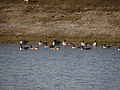
Canada geese on the gravel lake south of the area
.JPG)
.JPG)

.JPG)
Remarks
- ↑ The name “Pferd e broich” for the nature reserve was probably wrongly assigned. In maps and other official and historical sources as well as in the media and even on the information board about the nature reserve on site (see picture), the area is always called “Horse s broich”. Contrary to what the name suggests, the break actually has nothing to do with horses , but the name arose from the Celtic name Pert , which means something like ford or bridge (see Alfred Hunold: The last Indo-European lived a long time - in the surroundings of Korschenbroich: About a presumed retreat area of the Eburonen on the Lower Rhine . BoD - Books on Demand, 2012, ISBN 978-3-8423-5882-9 ( limited preview in the Google book search). ).
Web links
Individual evidence
- ↑ a b c d e f "Pferdsbroich" nature reserve (NE-009) in the specialist information system of the State Office for Nature, Environment and Consumer Protection in North Rhine-Westphalia , accessed on March 10, 2017.
- ↑ a b c d Information board on site
- ↑ a b c Pferdsbroich nature reserve. (No longer available online.) House of Nature - Biological Station in the Rhein-Kreis Neuss e. V., archived from the original on May 10, 2013 ; Retrieved December 2, 2013 . Info: The archive link was inserted automatically and has not yet been checked. Please check the original and archive link according to the instructions and then remove this notice.
- ^ A b Walter Normann: Spatial compatibility study: expansion of the Mönchengladbach regional airport . Spatial compatibility study according to § 14 Abs. 3 LPlG. 17. Change of the area development plan for the administrative district of Düsseldorf (GEP '99) in the area of the cities Mönchengladbach, Korschenbroich and Willich. District government Düsseldorf, March 2003 ( full text as PDF ).
- ↑ The landscape advisory board was informed about the plans to expand the airport: "We have already raised concerns" . In: Neuss-Grevenbroicher Zeitung (NGZ) . March 15, 2003 ( text online ). Text online ( Memento of the original from April 22, 2003 in the Internet Archive ) Info: The archive link was inserted automatically and has not yet been checked. Please check the original and archive link according to the instructions and then remove this notice.
- ^ Rheinkieswerk Kleinenbroich. (No longer available online.) KSV Kies & Splitt GmbH Rhein-Ruhr, archived from the original on March 2, 2013 ; Retrieved December 2, 2013 . Info: The archive link was inserted automatically and has not yet been checked. Please check the original and archive link according to the instructions and then remove this notice.
- ↑ Readymix wants to expand gravel areas . In: Neuss-Grevenbroicher newspaper . February 26, 2003 ( full text in the online archive ).
- ↑ a b c Korschenbroich: Habitat for common toads and frogs . In: Neuss-Grevenbroicher newspaper . July 26, 2010 ( full text in the online archive ).
- ^ Korschenbroich: A new lake in Kleinenbroich . In: Neuss-Grevenbroicher newspaper . March 8, 2011 ( full text in the online archive ).
- ^ Rhein-Kreis Neuss - The district administrator. Office for Development and Landscape Planning (ed.): Landscape plan part I, II, III, V, VI, including old ordinance of the district government. Scale 1: 25000 . April 2009 ( online as PDF ). Online as PDF ( Memento of the original from April 20, 2013 in the Internet Archive ) Info: The archive link was automatically inserted and not yet checked. Please check the original and archive link according to the instructions and then remove this notice.
- ^ H. Düllmann: Groundwater problems in the urban area of Korschenbroich - concept proposals for long-term solutions to prevent damage to buildings . Expert opinion on behalf of the city of Korschenbroich. Korschenbroich / Aachen May 2001 ( full text as PDF ).
- ↑ Simon Hopf: On the trail of the ice ages . Series Streifzug Nature and landscape experiences in the Rhine district of Neuss , 4th episode: Glacier, the Rhine and an old river island . In: Rheinische Post . August 11, 2009 ( full text in the RP online archive ).
- ↑ Simon Hopf: Adventure in the horse broich: In the deep thicket (= foray into nature and landscape experiences in the Rhein-Kreis Neuss . 7th episode). August 28, 2009 ( full text in the online archive ).
- ↑ NGZ- "Streifzug" through the horse brook: Adventure in the quarry forest. Neuss-Grevenbroicher Zeitung, August 28, 2009, accessed on December 2, 2013 .
- ^ Office for Urban Planning and Building Regulations of the City of Korschenbroich (Ed.): Caution Herkulesstaude !!! Information brochure. ( Download as PDF ).

Oil Gang Island (001) | Ilvericher Altrheinschlinge (002) | Zonser Grind (003) | Wahler Berg, Hannepützheide and Martinsee (004) | Uedesheimer Rheinbogen (005) | The Spey (006) | The Buersbach (007) | The Meerbusch (008) | Horse Broich (009) | Quartzite dome Liedberg (010) | At the black bridge (012) | Rheinaue Zons-Rheinfeld and Altrheinschlinge Zons (013) | Knechtsteden forest nature reserve (014) | Balgheimer See (015)