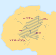
Ullemmeden basin
The Ullemmeden Basin (linguistic variants: Iwllemmedan-, Aulliminden, Ioullemmeden, Ouelleminden Basin ; French also: Le Bassin de I'Azawagh ) is a large inland basin located in the interior of West Africa , the territories of the states of Algeria , Niger , Nigeria , Mali and Benin covered. The name goes back to the Ullemmeden , who with around 200,000 people form the largest group of the Sahel - Tuareg .
geography
The north-south extension is almost 1000 km, the extension from west to east is about 800 km. The basin is largely congruent with the Azawagh catchment, a paleofluid system that now runs through the area as a network of wadis. The river had a catchment area of 556,000 km², more than 1/4 larger than that of the Volta .
It is assumed that the basin originated in the transitional period from the Permian to the Triassic ( Permian-Triassic border ) and that the existing faults formed during the Upper Cretaceous . Then during the Tertiary the basin was filled with sediment. Two distinctive faults run on the one hand from north-north-east to south-south-west, directly through the middle of the basin, on the other hand from west-south-west to east-north-east, near the Aïr Mountains. The sedimentation of the long period between Cambrian and Pleistocene resulted in a layer depth of 1500 to 2000 m.
raw materials
Valuable elements and minerals are stored in the Ullemmeden basin. In addition to uranium and copper , there are coal deposits and salt deposits. Niger is one of the world's largest producers of uranium.
Well-known deposits for uranium are the region around Gao , the Adrar des Ifoghas and the Aïr , for gold the Adrar des Ifogha and under the Azawagh Valley as well as Gao petroleum.
Conflicts and Humanitarian Disasters
The area suffered from famine in 1973, 1984 and 2005 due to drought and locust plagues, as well as economic reasons.
The Ullemmeden basin is located in the center of the Tuareg settlement area. accordingly there were conflicts and fighting in the region in 1961 / 62–1964 , 1990–1995 and most recently in 2012 .
Individual evidence
- ^ François Paris: Le bassin de l'Azawagh. Peuplements et civilizations, you neolithique à l'arrivée de l'islam. In: Alain Marliac (ed.): Milieux, sociétés et archéologues. Karthala et al., Paris 1995, ISBN 2-86537-576-5 , pp. 227-260, digitized version (PDF; 1.8 MB) .
- ↑ a b Richard TJ Moody: The Iullemmeden Basin. In: Richard C. Selley (Ed.): African basins (= Sedimentary Basins of the World. Vol. 3). Elsevier, Amsterdam et al. 1997, ISBN 0-444-82571-1 , pp. 89-103, doi : 10.1016 / S1874-5997 (97) 80008-1 , online .
- ↑ [1] Le fleuve Niger - de la foret tropicale guineenne au desert saharia. Les grands traits des regimes hydrologiques
- ↑ URANIUM GEOLOGY NIGER, WEST AFRICA ( Memento from July 14, 2011 in the Internet Archive ) (PDF; 276 kB)
- ↑ With open cards - News from Mali (2015)
- ↑ With Open Cards - Niger - Foreseeable Famine (2007)

