Weed
|
Weed
Municipality Hohenthann
Coordinates: 48 ° 39 ′ 35 ″ N , 12 ° 8 ′ 13 ″ E
|
||
|---|---|---|
| Height : | 446 m above sea level NN | |
| Incorporation : | January 1, 1949 | |
| Incorporated into: | Oberergoldsbach | |
|
Location of Unkofen in Bavaria |
||
|
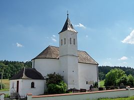
Catholic branch church of St. Nicholas
|
||
Unkofen is a district of the municipality of Hohenthann in the Lower Bavarian district of Landshut . Until 1945 it formed an independent municipality. Unkofen is located on the Goldbach about three kilometers east of Hohenthann.
history
Unkofen formed an open Hofmark , which in 1473 belonged to a Christoph Dorner. It was later ducal property and was mostly administered by the caretaker of the Kirchberg care court. On November 18, 1671, the electoral councilor and personal medicus Johann Jakob von Maffée (Maffei) received the Tratenfeld, Pogenhausen and Unkofen court brands as a gift. According to Michael Wening , Jobst Ernst Freinhuber von und zu Adlhausen still owned the Hofmark Unkofen in 1726 , "wherever he lives". From 1752 with Felix Leopold Freiherrn von Gugomos to 1788 the Freiherrn von Guggemos (Guggomos) are attested on the Hofmark, which they kept in their possession until after the secularization in Bavaria . The Baron von Guggomos'sche Patrimonial Court of Türkenfeld and Unkofen emerged as the successor to Hofmark .
The community of Unkofen belonged to the district court, district office and finally district of Rottenburg an der Laaber . On December 28, 1945, the American military government incorporated the communities of Oberergoldsbach and Unkofen into the community of Kläham . Oberergoldsbach was restored in 1949 including Unkofen. In the course of the regional reform in Bavaria , Unkofen came to Hohenthann on July 1, 1972 with the municipality of Oberergoldsbach.
Attractions
- Filialkirche St. Nikolaus : The simple baroque building from the first half of the 18th century was built over a late Romanesque complex from the first half of the 13th century.
societies
- Unkofen volunteer fire department
literature
- Günther Pölsterl: Mallersdorf: The Kirchberg Regional Court, the Eggmühl and Abbach nursing courts . I / LIII in the Historical Atlas of Bavaria , Munich 1979, ISBN 3 7696 9923 8 .

