
Hohenthann
| coat of arms | Germany map | |
|---|---|---|

|
Coordinates: 48 ° 40 ' N , 12 ° 6' E |
|
| Basic data | ||
| State : | Bavaria | |
| Administrative region : | Lower Bavaria | |
| County : | Landshut | |
| Height : | 487 m above sea level NHN | |
| Area : | 68.33 km 2 | |
| Residents: | 4189 (Dec. 31, 2019) | |
| Population density : | 61 inhabitants per km 2 | |
| Postal code : | 84098 | |
| Primaries : | 08784, 08781 | |
| License plate : | LA , MAY , MAL , ROL , VIB | |
| Community key : | 09 2 74 141 | |
| LOCODE : | DE OTA | |
| Community structure: | 62 districts | |
| Address of the municipal administration: |
Rathausplatz 1 84098 Hohenthann |
|
| Website : | ||
| Mayoress : | Andrea White ( CSU ) | |
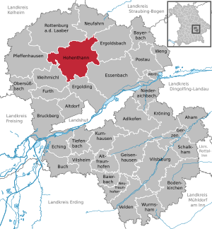
| Location of the municipality of Hohenthann in the Landshut district | ||
  |
||

.jpg)
Hohenthann is a municipality in the Lower Bavarian district of Landshut . The parish village of the same name is the main town of the community.
geography
Geographical location
Hohenthann is located north of Landshut in the Landshut planning region on the eastern edge of the Hallertau . The rural community is one of the largest in the district in terms of area.
Community structure
There are 62 districts:
|
|
|
|
There are the districts Andermannsdorf, Petersglaim, Schmatzhausen, Türkenfeld, Wachelkofen, Weihenstephan and Oberergoldsbach.
Neighboring communities
The neighboring communities (clockwise) are: Rottenburg an der Laaber , Neufahrn in Niederbayern , Ergoldsbach , Essenbach , Ergolding , Weihmichl and Pfeffenhausen .
|
Rottenburg an der Laaber 8 km |
Rottenburg an der Laaber 8 km |
Neufahrn in Lower Bavaria 14 km |
|
Pfeffenhausen 11 km |
.svg)
|
Ergoldsbach 11 km |
|
Weihmichl 8 km |
Ergolding 12 km |
Essenbach 13 km |
history


Until the church is planted
The occurrence of numerous Celtic entrenchments shows an early settlement. In Roman times the area belonged to the province of Raetia . Hohenthann is first mentioned in a document in 1125 in the Monumenta Augensia . The mentioned local noble family of the Hohenthanner was resident at the place until 1407. The Hofmark later belonged to the Counts of Deyring, who were also owners of the Hohenthann local court from the middle of the 17th century until 1818. The place was part of the Electorate of Bavaria and formed a closed Hofmark , whose seat was Hohenthann. In 1818 the forerunner of today's community was created with the Bavarian community edict.
Incorporations
In 1962, the previously independent municipality of Gambach was incorporated. On July 1, 1972, Oberergoldsbach (with the town of Unkofen recorded on January 1, 1949), Petersglaim, Türkenfeld, Wachelkofen and Weihenstephan were added. Andermannsdorf (with Kirchberg, which was incorporated on January 1, 1949) and Schmatzhausen followed on May 1, 1978.
History of the districts
Andermannsdorf is mentioned in a document as early as 822. The district of Kirchberg is mentioned with Count Arterius I as early as 812. Kirchberg was itself a municipality until 1945 and then belonged to Andermannsdorf until it was incorporated in 1978. The first written mention of Petersglaim ("Glaim") and Grafenhaun ("Hawn") can be found around the year 1140. Around 1133 the wife of Udalrich von Wolfstein donated an estate in the villa "Smuteshusa" to the St. Kastulus monastery in Moosburg . Türkenfeld is already known as "Turtinveld" at the beginning of the 11th century. Weihenstephan is first mentioned in a document in 1229 in the Bavarian Duke Surbar. The church in Weihenstephan is first mentioned in a document in 1259. The local castle was built by Georg Carl Freiherr von Etzdorf auf Weihenstephan and Stamsried († 1712) and is now owned by the Deroy von Fürstenberg family . In 1818 the municipalities of Andermannsdorf, Kirchberg, Oberergoldsbach, Petersglaim, Schmatzhausen, Türkenfeld, Wachelkofen and Weihenstephan were established with the Bavarian municipal edict.
Residents
According to the Bavarian State Office for Statistics , the number of inhabitants developed from 1840 to 1950 as follows:
- 1840: 2371 inhabitants
- 1871: 2726 inhabitants
- 1900: 2964 inhabitants
- 1925: 2968 inhabitants
- 1939: 2742 inhabitants
- 1950: 3960 inhabitants
According to the Bavarian State Office for Statistics , the population figures developed as follows on December 31 of each year:
| was standing | Residents |
|---|---|
| 1960 | 2744 |
| 1970 | 2637 |
| 1980 | 2676 |
| 1990 | 2767 |
| 1995 | 3254 |
| 2000 | 3633 |
| 2005 | 3804 |
| was standing | Residents |
|---|---|
| 2006 | 3773 |
| 2007 | 3761 |
| 2008 | 3804 |
| 2009 | 3852 |
| 2010 | 3843 |
| 2011 | 3823 |
| 2012 | 3835 |
| was standing | Residents |
|---|---|
| 2013 | 3936 |
| 2014 | 3995 |
| 2015 | 4063 |
| 2016 | 4094 |
| 2017 | 4121 |
| 2018 | 4170 |
Since 1972, the year of the municipal reform, the population has increased by 1383 people until 2015. This corresponds to a growth of 51.60 percent. This means that the population has grown by 7.69 (6.28) percent in the last ten (five) years.
In the period from 1988 to 2018, the population increased from 2,674 to 4,170 by 1,496 inhabitants or by 56%.
| Age | Residents by age |
|---|---|
| younger than 18 | 22.7% |
| 18 to 29 | 11.3% |
| 30 to 49 | 32.7% |
| 50 to 64 | 17.6% |
| older than 65 | 15.6% |
Religions
The vast majority of the population is Roman Catholic. There are three Catholic parishes of St. Laurentius in Hohenthann, St. Katharina in Schmatzhausen and St. Andreas in Andermannsdorf. These form a parish association of legally independent parishes, all belonging to the diocese of Regensburg .
politics
(2014: 75.24%)
Eight months after the end of the Second World War, the first local elections (municipal council elections) took place in the districts of Bavaria on January 27, 1946. In April and May 1946 the first elections for mayors, district administrators and district assemblies followed. In 2006 the 60th anniversary was celebrated.
The municipal tax revenue in 2011 was the equivalent of € 2,853,000, of which the trade tax income (net) was € 836,000.
The community is a member of the following special-purpose associations:
- Water maintenance association Landshut-Kelheim-Dingolfing-Landau
- Regional planning association Landshut
- Association for water supply Rottenburger Gruppe Pattendorf
The municipal administration provides 304 different official services.
Municipal council
The municipal council consists of 16 people. After the 2020 local election (for comparison: 2014 local election ), 13 (13) are men and three (three) women. It led to the following distribution of seats in the municipal council:
- CSU 8 (6) seats,
- Free voters 7 (6) seats and
- SPD 1 (1) seat.
The Hohenthanner Citizens and Environment List (H-BUL), which first appeared in the municipal council elections in 2014 and had three seats on the committee in the 2014–2020 electoral period, did not stand in 2020. It emerged from the “Clean Drinking Water” interest group.
In the election, 3,387 (3,066) citizens were entitled to vote; 2,500 (2,307) of them took part as voters, which corresponds to a turnout of 73.81 (75.24) percent. 2,459 (2,277) valid and 41 (30) invalid votes were cast.
The distribution of seats in the municipal council has developed as follows since 2008:
| CSU | SPD | FW | H-BUL | total | |
| 2008 | 5 | 1 | 10 | n / A | 16 seats |
| 2014 | 6th | 1 | 6th | 3 | 16 seats |
| 2020 | 8th | 1 | 7th | n / A | 16 seats |
mayor
Peter Dreier ( Free Voters ) was Mayor until he was elected District Administrator of Landshut in 2014 . In 2002 he succeeded Fritz Rauchenecker ( CSU ), who had previously been in office for 36 years. In the 2008 local elections Dreier was confirmed in office. The first round of the 2014 local elections did not result in an absolute majority for one of the three candidates. On March 30, 2014 Andrea Weiß (CSU) was elected as the new mayor in the runoff election. In the mayoral election on March 15, 2020, she was confirmed in office with 58.12 percent of the votes in the first ballot.
List of mayors since the territorial reform
| Term of office | mayor |
|---|---|
| until 2002 | Fritz Rauchenecker |
| 2002-2014 | Peter Dreier |
| since 2014 | Andrea White |
coat of arms
|
|
Blazon : “Split by blue and silver; in front a golden lion turned to the left, holding a golden ring in his raised left paw, behind a green fir tree with roots. "
The left part shows a lion with a ring in its paw, which was taken from the coat of arms of the noble family von Deuring , which was owner of the Hofmark and the local court of Hohenthann from approx. 1650 to 1818. The fir tree in the right part is due to the community name. The official description of the coat of arms ( blazon ) reads: Split of blue and silver; in front a golden lion turned to the left, holding a golden ring in his raised left paw, behind a green fir tree with roots. The municipality of Hohenthann has had this coat of arms since 1969, when a corresponding resolution was passed in the municipal council. This became official with the approval of the Bavarian Ministry of the Interior on December 3, 1969. |
Culture and sights
Architectural monuments

- Pilgrimage church Heiligenbrunn
- Kirchberg Castle
- Hohenthann Castle
- Weihenstephan Castle
- Filial church St. Giles in Türkenfeld (former castle chapel)
Natural monuments
- "Linden tree at the Sankt Andreas Church of Andermannsdorf" (draft ordinance laid out)
Regular events
- Beer festival with tent party (second weekend in July)
- Eichertreffen Türkenfeld (last weekend in August, every two years only in odd years)
- Brewery courtyard festival (mid-September, every two years only in even years)
- Christmas market (first Sunday in Advent)
additional
- Alois Riederer's Hobbit House (in the media since 2017 with increasing visitor interest)
Economy and Infrastructure
In 2011, according to official statistics, there were 10 in agriculture and forestry, 233 in manufacturing, 78 in trade, transport and hospitality, 17 in corporate service providers and 68 in public and private service providers at the place of work. Thus, a total of 406 people were employed at the place of work, including 256 men. There were a total of 1,412 employees at the place of residence subject to social security contributions, which corresponds to a commuter balance of −1,006.
As a result of a corresponding assessment of the economic strength of the municipality of Hohenthann, the key allocations rose by 5.2 percent from 777,856 euros in 2019 to 818,508 euros for 2020.
| Assignments to | year | |||||
|---|---|---|---|---|---|---|
| 2015 | 2016 | 2017 | 2018 | 2019 | 2020 | |
| Hohenthann community | 814.296 | 760.688 | 750.616 | 786.428 | 777.856 | 818.508 |
The Hohenthanner Castle Brewery has existed in Hohenthann since 1864 .
Agriculture and Forestry
In 1999 there were 161 farms with an agricultural area of 4,787 ha, of which 4,627 ha were arable land. By 2010 the agricultural area increased to 5,100 ha (+ 313 ha) or 4,966 ha of arable land (+ 339 ha). The stock of permanent grassland decreased from 159 to 132 ha (−27 ha). The number of farms fell by almost a third to 112 in the same period. The majority of holdings are over 50 hectares in size, followed by holdings between 20 and 50 hectares. Due to its location at the eastern end of the Hallertau, there are also some hop farmers in Hohenthann .
| Farm size in ha | Number of establishments | |
|---|---|---|
| 1999 | 2010 | |
| under 5 | 13 | 4th |
| 5 to under 10 | 22nd | 14th |
| 10 to under 20 | 33 | 17th |
| 20 to under 50 | 66 | 36 |
| 50 or more | 27 | 41 |
| total | 161 | 112 |
In 2010, grain was grown on 81.9 percent of the arable land.
Livestock farming has a large share in agricultural production in the municipality. From 1999 to 2010 the keeping of cattle and dairy cattle declined, while the number of pigs increased significantly.
| Animal species | number | |
|---|---|---|
| 1999 | 2010 | |
| Bovine | 1,595 | 820 |
| Dairy cows (already included in the total number of cattle) |
450 | 205 |
| Total pigs | 42,896 | 57,109 |
| Total chickens | 539 | 160 |
| Sheep | 121 | 39 |
An expansion of the pig population by a further 1,480 animals is planned for 2014.
Broadband coverage
As part of the guideline for the promotion of the development of high-speed networks in the Free State of Bavaria of July 10, 2014, the municipalities have a funding amount of at least 500,000 euros and a maximum of 950,000 euros; for Hohenthann this is 940,000 euros
building and living
| District | Residential areas designated building areas |
unplanned interior |
designated commercial building areas |
Farmland |
|---|---|---|---|---|
| Hohenthann | 100 € | 100 € | 40 € | € 6.50 |
| Schmatzhausen | 80 € | 80 € | € 6.50 | |
| Weihenstephan | 80 € | 80 € | € 6.50 | |
| Grafenhaun | 55 € | 55 € | € 6.50 | |
| Turk field | 50 € | 50 € | € 6.50 | |
| Oberergoldsbach | 50 € | 50 € | € 6.50 | |
| Andermannsdorf | 65 € | 50 € | € 6.50 | |
| Kirchberg | 45 € | € 6.50 | ||
| Boar stall | 40 € | € 6.50 | ||
| Weed | 40 € | € 6.50 | ||
| Untergambach | 50 € | € 6.50 |
Water supply

Intensive agriculture, especially pig fattening, has led to a considerable pollution of the groundwater and drinking water with nitrate in Hohenthann and the surrounding area. The trend of the water analyzes from 2005 to 2014 for the Hohenthann well shows an upward trend. The sampling from July 2014 (2013) showed a nitrate content of 38.1 (36.1) mg / l. The limit is 50 mg / l. Since the analysis year 2015, water from the Burghart fountain has been added to the water of the Hohenthann fountain; since 2017 also treated water from the Pattendorf well.
On September 19, 2012 and September 17, 2013, the Landshut District Office also issued special permits for deviations from the limit value for pesticide residues .
As part of a research project that is unique in Bavaria, the Technical University of Munich has been investigating the effects of intensive agriculture on water quality as well as possible solutions to reduce nitrate input since 2013 . The project is funded by the Bavarian State Ministry for Food, Agriculture and Forests and the Bavarian State Ministry for Environment and Consumer Protection .
traffic
State road St 2143 , which connects Landshut with Rottenburg and Langquaid , runs through Hohenthann . In addition, some district roads cross the municipality of Hohenthann.
energy
Today (as of February 21, 2014) electricity consumption in Hohenthann is around 28,083 MWh / year. This is offset by around 14,420 MWh / year of electricity produced in the municipality from renewable energy sources (recorded by the EEG - Renewable Energy Act). This means that the share of electricity from renewable energies in Hohenthann is 51%. (For comparison: In the Landshut district this share is 43%.) The largest expansion took place in the years 2008 to 2012.
Biomass
Around 3,968 MWh / year are generated in 3 biomass plants in the area of the municipality of Hohenthann.
There are biogas plants in the area of the municipality of Hohenthann in:
- Ettenkofen - 150 kW electric
- Pfarrkofen - 440 kW electric
- Stranz - 130 kW electric
Photovoltaics
Almost 10,451 MWh / year of solar power are produced in the area of the municipality with around 452 systems on the roofs of private, commercial or agricultural buildings.
Wind power
The names of the districts of Windham, Windkreuth and Windschlag indicate a windy area. There are currently no wind turbines in the municipality of Hohenthann . There is potential for the construction of wind turbines. By decision of January 13, 2014, the government of Lower Bavaria declared the sixth ordinance amending the Landshut regional plan to be binding, which regulates the availability of areas for wind power. Priority areas for wind power in the municipality of Hohenthann are therefore:
- WK30 Grafenhaun West
- WK32 Türkenfeld
- WK33 Oberergoldsbach
There is a reservation area :
- WK63 Petersglaim
As of April 2013, the municipality was in the process of changing the land use plan in order to identify further concentration zones for the use of wind power. On August 13, 2014, the elaboration of a development plan draft for the concentration zone W24 of the factual partial area use plan "Wind power" was commissioned and an application for the construction and operation of five wind turbines was dealt with in the municipal council. On September 10, the municipal council decided not to draw up a development plan for this. A 199-meter-high wind turbine near Wachelkofenreuth, which was planned in July 2016, was in test operation in February 2017.
There is a citizens' initiative against wind turbines.
Hydropower
There are no hydropower plants in the municipality of Hohenthann. There is no potential for this.
education
There are the following facilities:
- 3 childcare facilities: communal crèche, communal kindergarten, forest kindergarten
- 2 schools: Elementary school , participation in the Rottenburg Middle School Association (instead of the former Hohenthann elementary school )
Personalities
- Johann Rauchenecker (1853–1903), brewery owner and member of the Reichstag
- Peter Dreier (* 1966), local politician, since 2014 District Administrator of the Landshut district
Web links
- Official website of the municipality of Hohenthann
- Hohenthann: Official statistics of the LfStat
- Hohenthann at energymap.info
Individual evidence
- ↑ "Data 2" sheet, Statistical Report A1200C 202041 Population of the municipalities, districts and administrative districts 1st quarter 2020 (population based on the 2011 census) ( help ).
- ^ Hohenthann community in the local database of the Bavarian State Library Online . Bayerische Staatsbibliothek, accessed on April 4, 2014.
- ^ Wilhelm Volkert (ed.): Handbook of Bavarian offices, communities and courts 1799–1980 . CH Beck, Munich 1983, ISBN 3-406-09669-7 , p. 563 .
- ^ Federal Statistical Office (ed.): Historical municipality directory for the Federal Republic of Germany. Name, border and key number changes in municipalities, counties and administrative districts from May 27, 1970 to December 31, 1982 . W. Kohlhammer, Stuttgart / Mainz 1983, ISBN 3-17-003263-1 , p. 616 .
- ↑ a b c d e f Ed. Bavarian State Office for Statistics and Data Processing: Statistics communal 2012 - A selection of important statistical data for the municipality of Hohenthann 09 274 141 . PDF. Online at statistik.bayern.de. April 2013.
- ↑ Bavarian State Office for Statistics: 12111-101z Census and population update: municipality, population (census and current), reference dates . Online at www.statistikdaten.bayern.de, accessed on July 28, 2015.
- ↑ Bavarian State Office for Statistics and Data Processing: People by age (5 age groups) for Hohenthann (district: Landshut, district) - in% - . Online at results.zensus2011.de. Retrieved April 26, 2014.
- ↑ a b c Hohenthann municipality: result of the 2014 municipal council election on March 16, 2014 . Online at wahl.hohenthann.de, accessed on March 21, 2014.
- ↑ a b c Hohenthann municipality: election of the municipal council . Online at wahl.hohenthann.de; accessed on March 30, 2020.
- ↑ INFORMATION (To all households!); Published by the Adlkofen municipality, No. XX / 04 - 2006
- ↑ a b Bavarian Authority Guide - Hohenthann: Memberships in special-purpose associations , online at www.verwaltungsservice.bayern.de, accessed on November 2, 2019.
- ↑ H-BUL - Hohenthanner Citizens and Environment List: Homepage . Online at h-bul.de. Retrieved March 31, 2014.
- ↑ Bavarian State Office for Statistics and Data Processing: First Mayor / Lord Mayor in district communities . Online at statistikdaten.bayern.de, accessed on March 21, 2014.
- ^ Hohenthann municipality: quick report on the 2014 mayoral election on March 16, 2014 . Online at wahl.hohenthann.de. Retrieved March 16, 2014.
- ↑ contact person. Hohenthann community, accessed on August 22, 2020 .
- ↑ Municipality of Hohenthann quick report on the runoff election for the 2014 mayoral election on March 30, 2014 ( memento of the original from March 31, 2014 in the Internet Archive ) Info: The archive link was automatically inserted and not yet checked. Please check the original and archive link according to the instructions and then remove this notice. . Online at hohenthann.de, accessed on March 30, 2014.
- ^ Hohenthann municipality: election of the first mayor . Online at wahl.hohenthann.de; accessed on March 30, 2020.
- ^ Entry on Hohenthann's coat of arms in the database of the House of Bavarian History
- ↑ Announcement: Interpretation of the draft ordinance of an ordinance for the protection of the natural monument "Linde at the Sankt Andreas Church of Andermannsdorf" in the municipality of Hohenthann according to 28 BNatSchG, Landshut district, No. 23–1733.1 of July 29, 2014.
- ↑ a b Landshuter Zeitung: Vitamin injection for financially weak municipalities, December 12, 2015.
- ↑ Landshuter Zeitung: Key allocations 2017 of the municipalities, December 17, 2016.
- ↑ Landshuter Zeitung: Key assignments 2018, January 20, 2018.
- ↑ Landshuter Zeitung: Key assignments 2019, February 15, 2019.
- ↑ Landshuter Zeitung: Strong financial injection for the region, December 13, 2019.
- ↑ Landshuter Wochenblatt: Hops: Cultivated plants with tradition and "Green Gold" , September 7, 2016.
- ↑ a b Landshuter Zeitung: Local council meets, August 9, 2014.
- ↑ Bavarian Ministry of Finance, State Development and Homeland: Guideline for the Promotion of the Development of High-Speed Networks in the Free State of Bavaria (Broadband Guideline - BbR) . Announcement of July 10, 2014, Az.:75-O 1903-001-24929 / 14. PDF. Online at www.schnelles-internet-in-bayern.de, accessed on July 28, 2014 (PDF).
- ↑ Landshuter Zeitung: More funding for fast Internet, July 21, 2014.
- ↑ Landratsamt Landshut (expert committee): List of standard land values for the calendar years 2011 and 2012 . Online at landkreis-landshut.de. Retrieved December 20, 2014.
- ↑ a b Water supply association - Rottenburger Group -: Drinking water analysis , online at www.rottenburger-gruppe.de, accessed on October 26, 2019.
- ↑ Landshuter Wochenblatt: “Our water is getting worse and worse” . Online at wochenblatt.de, September 4, 2013.
- ↑ Landshuter Wochenblatt: Hohenthann becomes a research object for Bavaria, January 29, 2014
- ↑ a b c d e EnergyMap.Info: Hohenthann near Landshut, Isar . Online at www.energymap.info, accessed April 3, 2014.
- ^ Regional planning association Landshut: Printed matter No. 2.1 / 25. March 2014 - Submission to the planning committee of the regional planning association Landshut - Item 2.1: Sixth ordinance amending the regional plan Landshut; Creation of a chapter B VI Energy / sub-area wind Acknowledgment of the binding declaration . Online at www.region.landshut.org, accessed April 4, 2014.
- ↑ Landshuter Zeitung: Development plan finally off the table, September 15, 2014.
- ↑ Landshuter Zeitung: Local council meets on Tuesday.
- ↑ Landshuter Wochenblatt: Wind turbine: First test runs this week , February 1, 2017.
- ↑ Landshuter Zeitung: Ecology and Infrasound, September 20, 2014.

Adlkofen | Aham | Altdorf | Altfraunhofen | Baierbach | Bayerbach near Ergoldsbach | Bodenkirchen | Bruckberg | Buch am Erlbach | Eching | Ergolding | Ergoldsbach | Essenbach | Furth | Geisenhausen | Gerzen | Hohenthann | Kröning | Kumhausen | Neufahrn in Lower Bavaria | Neufraunhofen | Niederaichbach | Obersüßbach | Pfeffenhausen | Postau | Rottenburg an der Laaber | Schalkham | Tiefenbach | Velden | Vilsbiburg | Vilsheim | Weihmichl | Weng | Wörth on the Isar | Wormsham