
Weng (Isar)
| coat of arms | Germany map | |
|---|---|---|

|
Coordinates: 48 ° 40 ' N , 12 ° 22' E |
|
| Basic data | ||
| State : | Bavaria | |
| Administrative region : | Lower Bavaria | |
| County : | Landshut | |
| Management Community : | Wörth on the Isar | |
| Height : | 379 m above sea level NHN | |
| Area : | 15.62 km 2 | |
| Residents: | 1443 (Dec. 31, 2019) | |
| Population density : | 92 inhabitants per km 2 | |
| Postcodes : | 84187, 84164 | |
| Area code : | 08702 | |
| License plate : | LA , MAY , MAL , ROL , VIB | |
| Community key : | 09 2 74 188 | |
| Community structure: | 11 districts | |
| Address of the municipal administration: |
Am Kellerberg 2a 84109 Wörth adIsar |
|
| Website : | ||
| Mayor : | Robert Kiermeier ( Christian Citizens' Block ) | |
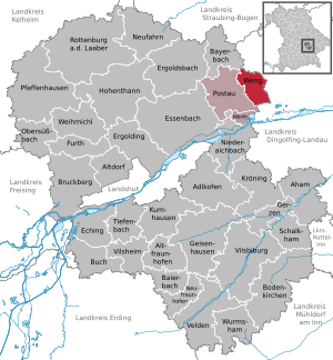
| Location of the municipality of Weng in the Landshut district | ||
  |
||


Weng is a municipality in the Lower Bavarian district of Landshut and a member of the Wörth adIsar administrative community .
geography
Geographical location
Weng is located in the Landshut region on the Isar .
Community structure
Weng has eleven districts:
There are the districts Veitsbuch and Weng.
history
Until the church is planted
The prehistoric barrows near Freihausen show that the area around Weng was settled very early . The first owners of what was then Moosweng Castle called themselves "von Weng" and were first mentioned in 1364. In the 15th century, the aristocratic Hermstorfer family owned all three court brands, Weng, Hinzlbach and Hörmannsdorf, which are located in what is now the municipality, and Hörmannsdorf has been named after the seat since the 13th century. Weng itself, where the “Wenger” family of doctors, known in the 16th century, had their ancestral home, belonged to the Counts of Seinsheim in the 17th and 18th centuries . Today's Weng Castle was acquired by Count Carl Arco von Oberköllnbach in 1806 and was still owned by Count Arco auf Valley until the early 1990s. In 1818 the municipalities of Weng and Hörmannsdorf were created by the Bavarian municipal edict. The aristocratic jurisdiction of the patrimonial courts Oberköllnbach (for Weng) and Hörmannsdorf initially continued until they were finally dissolved in 1848.
The current political municipality of Weng was created in 1852/53 through the merger of the municipalities of Weng and Hörmannsdorf.
Incorporations
On April 1, 1971, the municipality Veitsbuch was incorporated, the place had temporarily belonged to the Hofmark Oberköllnbach.
Residents
| was standing | Residents |
|---|---|
| 1877 | 680 |
| 1928 | 668 |
| 1952 | 816 |
According to the Bavarian State Office for Statistics , the population figures developed as follows on December 31 of each year:
| was standing | Residents |
|---|---|
| 1960 | 952 |
| 1970 | 930 |
| 1980 | 957 |
| 1990 | 1011 |
| 1995 | 1144 |
| 2000 | 1326 |
| 2005 | 1405 |
| was standing | Residents |
|---|---|
| 2006 | 1392 |
| 2007 | 1397 |
| 2008 | 1408 |
| 2009 | 1382 |
| 2010 | 1396 |
| 2011 | 1385 |
| 2012 | 1388 |
| was standing | Residents |
|---|---|
| 2013 | 1434 |
| 2014 | 1410 |
| 2015 | 1434 |
| 2016 | 1441 |
| 2017 | 1460 |
| 2018 | 1445 |
Since 1972, the year of the municipal reform, the population has increased by 496 people until 2016. This corresponds to a growth of 52.49 percent. In the last ten (five) years the population grew by 3.15 (3.82) percent.
| Age | Residents by age |
|---|---|
| younger than 18 | 22.1% |
| 18 to 29 | 13.5% |
| 30 to 49 | 31.7% |
| 50 to 64 | 19.7% |
| older than 65 | 12.9% |
politics
Eight months after the end of the war, the first municipal elections (municipal council elections) took place in the municipalities of Bavaria on January 27, 1946. In April and May 1946 the first elections for mayors, district administrators and district assemblies followed. In 2006 the 60th anniversary was celebrated.
The municipality of Weng is a member of the following special-purpose associations:
- Regional planning association Landshut
- School Association Niederaichbach-Wörth Postau-Weng
- School Association Postau-Weng
- Water Association Mallersdorf
Weng is part of the Wörth adIsar administrative association .
| local community | coat of arms | Area km² |
Resident December 31, 2019 |
PE density PE per km² |
Height above sea level |
|---|---|---|---|---|---|
| Postau | 34.84 | 1,629 | 47 | 388 | |
| Weng | 15.62 | 1,443 | 92 | 379 | |
| Wörth adIsar | 4.84 | 3,030 | 626 | 369 |
The Wörth adIsar administrative community provides 304 different official services.
mayor
Mayor has been Robert Kiermeier (Christian Citizens' Block) since May 1996.
coat of arms
Blazon : "Divided, split at the top, split by silver and blue six times at the front, a silver chalice in blue at the back, a red linden leaf shield base in silver below ."
Architectural monuments
Economy and Infrastructure
In 1998, according to official statistics, there were no employees at the place of work in the manufacturing sector 63 or in the trade and transport sector. In other economic sectors 58 people were employed at the place of work subject to social security contributions. There were a total of 486 employees at the place of residence subject to social security contributions. There were two companies each in manufacturing and construction. Many residents commute to the neighboring BMW plant in Dingolfing.
| Assignments to | year | |||||
|---|---|---|---|---|---|---|
| 2015 | 2016 | 2017 | 2018 | 2019 | 2020 | |
| Weng community | 358.076 | 327.876 | 348,572 | 293,316 | 401.720 | 271,656 |
As a result of a corresponding assessment of the economic strength of the municipality of Weng, the key allocations in 2018 were set at 293,316 euros. In the years 2015 to 2017, they were between 327,876 and 358,076 euros. In 2018, they fell below 300,000 euros. In the following year, they rose again by 37 percent to 401,720 euros and then decreased again by 32.4 percent to 271,656 euros in 2020.
The municipal tax revenue amounted to the equivalent of € 397,000 in 1999, of which the trade tax income (net) amounted to the equivalent of € 10,000.
Agriculture and Forestry
In 1999 there were 41 farms with an agriculturally used area of 1,040 hectares, of which 952 hectares were arable land and 88 hectares were permanent green areas.
building and living
| District | Residential areas designated building areas |
unplanned interior |
designated commercial building areas |
Farmland |
|---|---|---|---|---|
| Weng | 90 € | 80 € | 40 € | 5 € |
| Hörmannsdorf | 80 € | € 70 | 5 € | |
| Vitus Book | 65 € | 5 € | ||
| Moosberg | 65 € | 5 € | ||
| Hackers | 50 € | 5 € |
education
The following institutions exist (as of: 1999):
- Kindergartens: 50 kindergarten places with 87 children
- Musikverein: founded by Anton Edenhoffer
Web links
- Entry on the coat of arms of Weng (Isar) in the database of the House of Bavarian History
Individual evidence
- ↑ "Data 2" sheet, Statistical Report A1200C 202041 Population of the municipalities, districts and administrative districts 1st quarter 2020 (population based on the 2011 census) ( help ).
- ↑ Bayerische Landesbibliothek: Search result Weng . Online at bayerische-landesbibliothek.online.de. Retrieved May 17, 2014.
- ^ Max Döllner : Development history of the city of Neustadt an der Aisch until 1933 . 1950; 2nd Edition. Ph. CW Schmidt, Neustadt an der Aisch 1978, ISBN 3-87707-013-2 , p. 524.
- ↑ Hans-Dieter Becher: Historical Atlas of Bavaria: Landshut. The city of Landshut and the district court Rottenburg (Altbayern 43) , Munich 1978, pp. 281 ff., 284 ff., 287 ff., 468 ff.
- ^ Wilhelm Volkert (ed.): Handbook of Bavarian offices, communities and courts 1799–1980 . CH Beck, Munich 1983, ISBN 3-406-09669-7 , p. 508 .
- ↑ a b c bavarikon location database
- ↑ Bavarian State Office for Statistics and Data Processing: People by age (5 age groups) for Weng (district: Landshut, district) - in% - . Online at results.zensus2011.de. Retrieved April 27, 2014.
- ↑ INFORMATION (To all households!); Published by the Adlkofen municipality, No. XX / 04 - 2006
- ↑ Bavarian Authorities Guide - Community of Weng: Memberships in special-purpose associations and number of residents , online at www.verwaltungsservice.bayern.de, accessed on November 3, 2019.
- ↑ Bavarian authorities guide - Wörth adIsar administrative community: Wörth adIsar administrative association - Landshut district , online at www.verwaltungsservice.bayern.de, accessed on November 3, 2019.
- ↑ a b Landshuter Zeitung: Vitamin injection for financially weak municipalities, December 12, 2015.
- ↑ Landshuter Zeitung: Key allocations 2017 of the municipalities, December 17, 2016.
- ↑ Landshuter Zeitung: Key assignments 2018, January 20, 2018
- ↑ Landshuter Zeitung: Key assignments 2019, February 15, 2019.
- ↑ Landshuter Zeitung: Strong financial injection for the region, December 13, 2019.
- ↑ Landratsamt Landshut (expert committee): List of standard land values for the calendar years 2011 and 2012 . Online at landkreis-landshut.de. Retrieved December 19, 2014.

Adlkofen | Aham | Altdorf | Altfraunhofen | Baierbach | Bayerbach near Ergoldsbach | Bodenkirchen | Bruckberg | Buch am Erlbach | Eching | Ergolding | Ergoldsbach | Essenbach | Furth | Geisenhausen | Gerzen | Hohenthann | Kröning | Kumhausen | Neufahrn in Lower Bavaria | Neufraunhofen | Niederaichbach | Obersüßbach | Pfeffenhausen | Postau | Rottenburg an der Laaber | Schalkham | Tiefenbach | Velden | Vilsbiburg | Vilsheim | Weihmichl | Weng | Wörth on the Isar | Wormsham