
Bottom end
|
Bottom end
City of Papenburg
Coordinates: 53 ° 5 ′ 10 ″ N , 7 ° 23 ′ 20 ″ E
|
|
|---|---|
| Height : | 2–8 m |
| Area : | 9.73 km² |
| Residents : | 12,402 (Jan 1, 2013) |
| Population density : | 1,275 inhabitants / km² |
| Postal code : | 26871 |
| Area code : | 04961 |
  Location from below in Papenburg
|
|


The bottom end is a district of the city of Papenburg , the longest and oldest fen town in Germany, in the northern Emsland and has over 12,000 inhabitants. The lower end is the origin of the development of today's city and is traversed by canals that flow from the upper end over the port in the north into the Ems .
history
Culture and sights
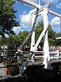
Drawbridge on the main canal at the bottom
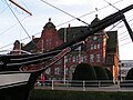
Papenburg Town Hall; in front of it in the main canal the brig Friederike von Papenburg
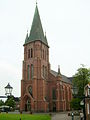
St. Antonius Church on the main canal

Meyer's mill on the main canal

Boilermakers at the Alte Werft site


Web links
Wikivoyage: Papenburg-bottom end - travel guide