Unterbacher See
| Unterbacher See | ||
|---|---|---|

|
||
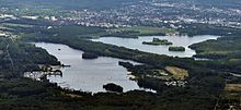
| Unterbacher See looking east from the north bank | ||
| Geographical location | North Rhine-Westphalia , Germany | |
| Tributaries | none, from groundwater | |
| Drain | none | |
| Places on the shore | Düsseldorf-Unterbach | |
| Location close to the shore | Düsseldorf , Erkrath , Hilden | |
| Data | ||
| Coordinates | 51 ° 11 '41 " N , 6 ° 53' 30" E | |
|
|
||
| surface | 84 ha | |
| volume | 4,110,000 m³ | |
| Maximum depth | 13.4 m | |
| Middle deep | 4.9 m | |
| PH value | 8.4 | |

The Unterbacher See is a quarry pond in the Unterbach district in the southeast of Düsseldorf .
description
The Unterbacher See is a quarry pond created by gravel. It is 83.6 hectares in size and up to 13.4 m deep. Like many quarry ponds, it has no inflows or outflows, but is fed exclusively from groundwater .
The nature reserve Unterbacher See / Eller Forst is located around the lake , which largely consists of loose forest. There are numerous hiking and biking trails within this forest. In the lake itself there are four islands designated as a bird sanctuary. The water is connected to the spawning pond and the adjacent Eselsbach via a ditch. It was created by dredging to extract gravel and sand between 1926 and 1973. During the Second World War, a mock airfield of the German Air Force was located here to deceive Allied bombers .
The lake represents an important local recreation area for the greater Düsseldorf area and is administered by the Zweckverband Erholungsgebiet Unterbacher See , which was founded on February 7, 1956 and consists of the neighboring cities of Düsseldorf , Erkrath and Hilden . Camp , a high ropes course and beaches can be found and the south shore, the latter also on North Nudist - beach . The lido north was opened with a bathhouse in 1959, the lido south followed in 1966. The lido north is guarded by the DLRG water rescue service and the Unterbacher See association. On the north bank there is also a viewing terrace with a restaurant, a mini golf course and a small sailing boat harbor with boat rental, as well as a rowing boat harbor used by Düsseldorf and Erkrath schools . There are parking spaces at both lido, but they are quickly occupied when the weather is good. Arrival is also possible by bus and bike .
The Elbsee lies on the other side of the neighboring federal motorway 46 . It can be reached by pedestrians and cyclists through an underpass.
ecology
Because of the drought and heat in Europe in 2018 , the cyanobacteria increased in the lake, so that the lido north had to close for two weeks on July 29, 2018.
See also
Web links
Individual evidence
- ↑ a b c d Documentation of the condition and development of the most important lakes in Germany: Part 9 North Rhine-Westphalia, Rhineland-Palatinate & Saarland (PDF; 576 KB)
- ↑ Unterbacher See - local recreation area with high recreational value. (No longer available online.) City of Düsseldorf, archived from the original on July 16, 2015 ; accessed on August 12, 2015 . Info: The archive link was inserted automatically and has not yet been checked. Please check the original and archive link according to the instructions and then remove this notice.
- ↑ http://www.rggerresheim.de/new/?x=rgg Düsseldorfer Schule in the rowing port at Unterbacher See
- ↑ http://www.srg-erkrath.de/index.php?module=pagemaster&PAGE_user_op=view_page&PAGE_id=3&MMN_position=10:10 Erkrath school in the rowing boat harbor at Unterbacher See
- ↑ Lido at Unterbacher See closed due to algae plague In: nrz.de , July 29, 2018, accessed on July 30, 2018.
