
Lower Neckar: Wörthel
|
Nature reserve "Lower Neckar: Wörthel"
|
||
 |
||
| location | Mannheim district in Baden-Wuerttemberg , Germany | |
| surface | 20.9 ha | |
| Identifier | 2101 | |
| WDPA ID | 166011 | |
| Geographical location | 49 ° 29 ' N , 8 ° 32' E | |
|
||
| Setup date | 17th December 1986 | |
| administration | Karlsruhe Regional Council | |

The Wörthel is a nature reserve in Mannheim .
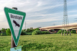
It is part of the “Lower Neckar” nature and landscape protection area, which is divided into six protected areas from Heidelberg to Mannheim. The Neckar is characterized here by a strong agro-cultural and technical-industrial use and change. The nature reserve is bordered by the Neckar Canal in the north and the Mannheim Kurpfalzbrücke – Edingen – Heidelberg railway line in the south, and runs to the hydropower plant in the west and the motorway bridge of the Federal Motorway 6 in the east. It is flowed through by the Altneckar, which leads only a small amount of water through the water drainage into the canal and only has the natural amount of water during floods. Willow bushes , reeds and tall herbaceous vegetation grow on the banks . The breeding habitat of the kingfisher and sand martin can be found . The 20.9 hectare nature reserve was designated in 1987. The protection purpose is the preservation of the near-natural Neckar section with its floodplain .
See also
View towards the motorway bridge

Information sign by the wayside


literature
- Thomas Breunig, Siegfried Demuth: Naturführer Mannheim , Verlag Regionalkultur 2000, ISBN 978-3-89735-132-5 , p. 86
- District Office for Nature Conservation and Landscape Management Karlsruhe (Ed.): The nature reserves in the administrative district of Karlsruhe . Thorbecke, Stuttgart 2000, ISBN 3-7995-5172-7 , s. 609
Web links
- Profile of the nature reserve in the LUBW's list of protected areas

