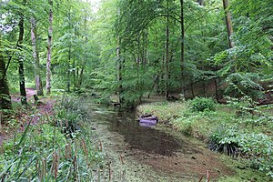
Lower Remstal with peripheral areas
|
Landscape protection area "Lower Remstal with peripheral areas"
|
||
| location | Remseck am Neckar in the district of Ludwigsburg and Waiblingen in the Rems-Murr district in Baden-Württemberg , Germany | |
| surface | 2.503 km² | |
| Identifier | 1.18.008 and 1.19.012 | |
| WDPA ID | 325353 | |
| Geographical location | 48 ° 51 ' N , 9 ° 19' E | |
|
|
||
| Setup date | April 6, 1987 | |
| administration | Regional Council Stuttgart | |
Lower Remstal with peripheral areas is a landscape protection area in the districts of Ludwigsburg (protection area number 1.18.008) and Rems-Murr-Kreis (protection area number 1.19.012).
Location and description
The landscape protection area was created by ordinance of the Stuttgart regional council as higher nature conservation authority of April 6, 1987. When this ordinance came into force, parts of the Lower Remstal landscape protection ordinance of the Waiblingen district office of November 4, 1968 and the Lower Remstal landscape protection ordinance of the Ludwigsburg district office of July 21, 1967 expired . It essentially comprises the valley of the lower Rems between the towns of Waiblingen and Remseck as well as adjacent areas of the Gäuflächen. It belongs to the natural area 123- Neckar basin within the natural main unit 12- Neckar- and Tauber-Gäuplatten .
The landscape protection area has a size of 120.0 hectares in the Ludwigsburg district and 131.0 hectares in the Rems-Murr district, it serves as a buffer zone and supplementary area for the nature reserve No. 1149 Lower Remstal and therefore largely encloses it. The entire area is almost entirely in the EU bird sanctuary 7121-442 Lower Remstal and partly also in FFH area No. 7121-341 Lower Remstal and Backnanger Bay .
Protection purpose
The essential protection purpose according to the Protected Areas Ordinance is
- securing the ecologically necessary buffer zone between the intensively used agricultural area, the settlement area, the traffic routes and the nature reserve and the flora and fauna living there;
- the maintenance and securing of the large sliding slope areas with their typical use of arable land, grassland or garden;
- the preservation of the ecologically valuable meadow orchards with their diverse range of species, of unused wasteland with shrub formations, hedges or semi-arid grassland-like communities;
- the securing of the outer slope areas, which merge into the elevated or gully areas, which underline and complement the scenic beauty of the valley landscape and morphologically transition to the steep slopes.
See also
- List of landscape protection areas in Baden-Württemberg
- List of landscape protection areas in the Rems-Murr district
- List of landscape protection areas in the Ludwigsburg district
Web links
- Profile of the landscape protection area in the protected area directory of the LUBW (Rems-Murr-Kreis)
- Profile of the landscape protection area in the protected area directory of the LUBW district of Ludwigsburg


