Uphall
| Uphall | ||
|---|---|---|
| Uphall Parish Church | ||
| Coordinates | 55 ° 56 ′ N , 3 ° 30 ′ W | |
|
|
||
| administration | ||
| Post town | BROXBURN | |
| ZIP code section | EH52 | |
| prefix | 01506 | |
| Part of the country | Scotland | |
| Council area | West Lothian | |
| British Parliament | Livingston | |
| Scottish Parliament | Linlithgow | |
Uphall is a village in the northeast of the Scottish Council Area West Lothian or in the traditional county of Linlithgowshire . It is located around three kilometers northeast of Livingston and 20 kilometers southwest of central Edinburgh on the Brox Burn . The neighboring village of Broxburn borders directly on the eastern edge .
history
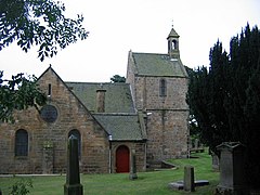
There was already a church in Uphall before the Reformation . The lawyer John Shairp purchased a piece of land in Uphall in 1569. The manor Houstoun House was built there from 1600 . Today it houses a hotel.
Uphall earlier was slate mined. Paraffin was also produced in this context .
traffic
Uphall is conveniently located in the Edinburgh area. The A899 that branches off from the A71 at Mid Calder . The A89 ( Glasgow - Newgate ) is tangent to the southern edge . It connects the village to the M8 and M9 within a few kilometers .
In the 19th century Uphall received its own station on the North British Railway . It is still in operation today. The Union Canal, opened in 1822, runs through Broxburn . The Edinburgh Airport is located eight kilometers to the east.
Individual evidence
- ↑ a b Entry in the Gazetteer for Scotland
- ^ A b c Uphall in: FH Groome (ed.): Ordnance Gazetteer of Scotland: A Survey of Scottish Topography, Statistical, Biographical and Historical , Grange Publishing Works, Edinburgh, 1882–1885.
- ↑ Listed Building - Entry . In: Historic Scotland .
- ^ Website of the Houstoun House Hotel

