Urmiberg
| Gottertli | ||
|---|---|---|
|
From the ascent to Rigi-Hochflue you can also see the Urmiberg |
||
| height | 1395 m above sea level M. | |
| location | Canton of Schwyz , Switzerland | |
| Mountains | Rigi massif, Schwyz Alps | |
| Dominance | 1.5 km → Rigi Hochflue | |
| Notch height | 108 m ↓ Egg | |
| Coordinates | 686 651 / 207341 | |
|
|
||
| particularities | Highest point of the Urmiberg | |
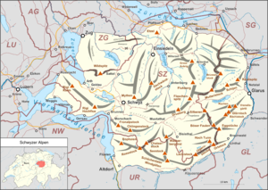
The Urmiberg is a foothill of the Rigi in the east and is located in the Swiss canton of Schwyz in the Schwyz Alps .
The name is indicative of the southeast slope in the municipality of Ingenbohl , more precisely in the village of Brunnen . It is bounded to the west by the foothills of the Rigi Hochflue ; its highest point, Gottertli, is a resting place and a lookout point at 1395 m above sea level. M.
The foothills begin at the Hochflue (also Hoflue ), a mountain peak at 1698 m above sea level. M. The ridge along the municipal boundary between Ingenbohl and leads Lauerz . On the north side respectively. in Lauerz is the north-western slope known as Büelerberg . The Fallenbach flows from the south side into Lake Lucerne . At the mouth of the eponymous former hotel, which by 1994 is Fallbach shooting of Marcel Strebel nationwide hit the headlines.
From the halts ( 436 m above sea level ) on the western edge of Brunnen, a cable car leads to Timpel ( 1128 m above sea level ), the center of the Urmiberg. The Timpelweid restaurant is right next to the mountain station.
Characteristic of the Urmiberg are the Lower and Upper Brunniberg - the latter popularly known as the Duume (thumb) - two boulders that protrude from the mountain.
The Urmiberg and Büelerberg are also used to transport electrical energy: the Gotthard and Lukmanier lines pass the ridge .
In 2017 the Urmiberg is also featured in the book “Summit. Reunion on the Urmiberg ”by the Schwyz author Blanca Imboden became known in Switzerland.


