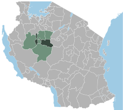
Uyui (District)
| Uyui District | |
|---|---|
 |
|
| Basic data | |
| Country | Tanzania |
| region | Tabora |
| surface | 13,453 km² |
| Residents | 396,623 (2012) |
| density | 29 inhabitants per km² |
| ISO 3166-2 | TZ-24 |
Coordinates: 4 ° 56 ′ S , 32 ° 40 ′ E
Uyui , also called "Tabora District", is a district in the Tanzanian region of Tabora . The district encloses the city of Tabora and borders the Shinyanga region and the Nzega and Igunga districts to the north, the Singida region to the east, the Sikonge district to the south and the Urambo and Kaliua districts to the west .
geography
Uyui has an area of 13,453 square kilometers and around four hundred thousand inhabitants (2012 census). The district is located northwest and east of the regional capital Tabora on the central Tanzanian plateau at an altitude of 1100 to 1200 meters above sea level. The plain is broken through only by flat hills and gentle river valleys. Most streams and rivers only have temporary water. The western district part drained to the river Malagarasi that in the Lake Tanganyika flows, the eastern part over the river Manonga in Wembere marsh and lake Kitangiri which during floods in the Lake Eyasi drained. The district has a tropical savanna climate, Aw according to the effective climate classification . The precipitation of less than 1000 millimeters per year falls mostly in the months of November to April, the dry season from June to September is almost free of precipitation. The average temperature is 23 degrees Celsius.
history
Uyui District was established in 1983.
Administrative division
Uyui consists of 24 parishes (wards):
- Lutende
- Kizengi
- Goweko
- Igalula
- Ilolanguru
- Mabama
- Ndono
- Ufulumwa
- Usagari
- Ibiri
- Bukumbi
- Ikongolo
- Upuge
- Magiri
- Isikizya
- Shitage
- Loya
- Miswaki
- Tura
- Nsololo
- Kigwa
- Miyenze
- Nsimbo
- Ibelamilundi
populationThe population rose from 281,101 in 2002 to 396,623 in 2012. This corresponds to an annual growth of 3.4 percent and a doubling time of twenty years. In 2012, forty percent of those over the age of five spoke Swahili, three percent spoke English and Swahili, and 57 percent were illiterate. Facilities and services |
 |
- Education: There are 114 elementary schools and 16 secondary schools in the district.
Economy and Infrastructure
|
 |
politics
In Uyui, a District Council is elected every 5 years. In the 2019 election, Said Ntahondi was elected chairman.
Others
- Child labor: Child labor is a general problem in Tanzania. Their reduction is closely related to the improvement in school education. From 2016 to 2017, Japan Tobacco International (JTI) financed a study by the International Labor Organization (ILO) on how child labor can be reduced.
Web links
Individual evidence
- ^ A b Tanzania Regional Profiles, 14 Tabora Regional Profiles. (PDF) The United Republic of Tanzania, 2016, p. 16 , accessed on April 17, 2020 .
- ↑ a b CAPACITY DEVELOPMENT FOR RESULTS-BASED MONITORING, EVALUATION AND AUDITING, UYUI DISTRICT. (PDF) Economic and Social Research Foundation, August 2013, p. 3 , accessed April 19, 2020 .
- ↑ Maps for the World, Map 500k - xb36-1, Map 500k - xb36-2. Russian Army Maps, accessed April 17, 2020 (Russian).
- ↑ Tabora climate: Average Temperature, weather by month, Tabora water temperature - Climate-Data.org. Retrieved April 17, 2020 .
- ↑ a b Tabora Dc | TABORA REGION ADMINISTRATIVE SECRETARY. Retrieved April 17, 2020 .
- ↑ History | Tabora District Council. Retrieved April 18, 2020 .
- ↑ 2012 Population and Housing Census. (PDF) National Bureau of Statistics and Ministry of Finance, March 2013, p. 134 , accessed April 18, 2020 .
- ^ Tanzania Regional Profiles, 14 Tabora Regional Profiles. (PDF) The United Republic of Tanzania, 2016, p. 75 , accessed on April 18, 2020 .
- ↑ Takwimu | Statistics. Retrieved April 18, 2020 (English).
- ^ Tanzania Regional Profiles, 14 Tabora Regional Profiles. (PDF) The United Republic of Tanzania, 2016, pp. 167, 169, 172 , accessed April 19, 2020 .
- ^ The Tanzanian railway system. (PDF) Clyde & Co Tanzania, October 2013, accessed April 19, 2020 .
- ↑ a b Uyui. GoogleMaps, accessed April 19, 2020 (de-US).
- ^ Trunk Roads Network. (PDF) Retrieved April 19, 2020 .
- ↑ Tanzania in Figures 2018. (PDF) National Bureau of Statistics, June 2019, p. 67 , accessed April 19, 2020 .
- ^ Siegfried Schröder and Elke Kuhne: Elections in Tanzania 2015. (PDF) Rosa-Luxemburg-Stiftung, November 9, 2015, p. 3 , accessed on April 19, 2020 .
- ↑ Mwanzo. Retrieved April 19, 2020 (English).
- ^ The Achieving Reduction of child labor in Support of Education (ARISE) project in Tabora, Tanzania . June 7, 2017 ( ilo.org [accessed April 19, 2020]).
