
Vârful Parângul Mare
| Vârful Parângul Mare | ||
|---|---|---|
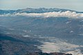
 The main ridge of the Parâng Mountains with the Vârful Parângul Mare from the north |
||
| height | 2519 m | |
| location | Communities Crasna , Petrila and Petrosani , circles Gorj and Hunedoara , Romania | |
| Mountains | Munții Parâng , Southern Carpathians | |
| Notch height | 2103 m ↓ In the Transylvanian Basin northwest of Sibiu | |
| Coordinates | 45 ° 20 '28 " N , 23 ° 32' 26" E | |
|
||

The Vârful Parângul Mare ( Hungarian : Nagy-Páring ) is the highest peak of the Parâng Mountains in the Romanian Southern Carpathians . It lies on the border ridge between the historical regions of Transylvania and ( Little ) Wallachia . With a notch height of 2103 m, it is the most prominent mountain in the country even before the Vârful Moldoveanu . The shortest, well-marked ascent leads from the Stațiunea Parâng ski area via the Refugiul Cârja (also known as "Rudolfshütte") and up the Vârful Cârja .
Maps & literature
- SC Schubert & Franzke Srl (ed.): Colecția Munții Noștri 1: 50,000, sheet MN12: Parâng
- Birgitta Gabriela Hannover Moser: Rother hiking guide Romania - Southern Carpathians. Bergverlag Rother , Oberhaching, 2017, ISBN 978-3-7633-4467-3
- Janneke Klop: Trekking the Mountains of Romania. Cicerone, Kendal, 2020, ISBN 978-1-85284-948-1
photos
The Jiu and Retezat mountains east of Parâng Mountains from

The Refugiul Cârja (also "Rudolfshütte")


Individual evidence
- ↑ Parângul Mare on OpenStreetMap, accessed on June 3, 2020
- ↑ https://www.peakbagger.com/KeyCol.aspx?pid=10321
- ↑ https://www.peakbagger.com/list.aspx?lid=43490
- ^ Birgitta Gabriela Hannover Moser: Rother hiking guide Romania - Southern Carpathians. Bergverlag Rother, Oberhaching, 2017, pp. 101-104
- ↑ https://muntii-nostri.ro/ro/productdisplay/mn12-harta-de-drumetie-muntilor-parang