
Val d'Uina
| Val d'Uina | ||
|---|---|---|
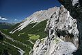
 The Val d'Uina from the opposite slope of the Inn Valley |
||
| location | Graubünden (Switzerland) and South Tyrol (Italy) | |
| Waters | Uina | |
| Geographical location , ( CH ) | 46 ° 48 '3 " N , 10 ° 22' 47" O ( 824 465 / 187501 ) | |
|
||
| height | 2000 m | |
| use | Popular MTB route when crossing the Alps | |

The Val d'Uina ( ) is a small side valley of the Lower Engadine between the Piz S-chalambert in the north-east and Piz Lischana in the south-west. The Uina flows through it and flows into the Inn Valley at Sur En .
In the valley lie the two hamlets Uina Dadaint and Uina Dadora, which were inhabited all year round for centuries and are only cultivated in summer today. In Uina Dadaint there is still a house and a stable with a barn. In Uina Dadora, at 1499 m , the Val Curtinatsch, the largest side valley of the Val d'Uina, begins.
In Sursass, in the back of the valley, the Graubünden municipality of Sent owns an alp with 650 hectares that is leased to the municipality of Mals in South Tyrol . At the lowest point of Alp Sursass, the streams coming from Plateau da Rims, Val Cristanas and Pass da Schlingia unite and dig the deep Quar gorge into the limestone. The gorge was originally inaccessible. Sursass could only be reached from the Engadine side via La Stüra or Val da Gliasen. From 1908 to 1910, at the instigation of the German Alpine Club (Pforzheim Section) and the Canton of Graubünden , the Baratelli company built an approx. 1000 m long rock path with two tunnels and a gallery in the vertical wall. The canton of Graubünden shared the costs of CHF 32,500 with CHF 19,000 and the Pforzheim Section of the Alpine Association with CHF 13,500. The community of Sent pays the costs of maintenance and repair to this day. In 2010 the municipality of Sent celebrated its 100th anniversary.
The border between the canton of Graubünden and the Italian province of South Tyrol runs right through the valley floor of Sursass, around 500 m northwest of the watershed at the Pass da Schlingia.
Hikers and mountain bikers use the route between Mals in Italy and Sur En in Switzerland through the Schlinigtal over the Schlinigpass and through the Val d'Uina. The valley is part of the Joe Route , an important alpine crossing tour.
View from the Quar Gorge into the Val d'Uina

A path carved into the rock in the Quar Gorge

Uina Dadora


_2.jpg)