
Várpalota
| Várpalota | |||||
|
|||||
| Basic data | |||||
|---|---|---|---|---|---|
| State : | Hungary | ||||
| Region : | Central Transdanubia | ||||
| County : | Veszprém | ||||
| Small area until December 31, 2012 : | Várpalota | ||||
| Coordinates : | 47 ° 12 ' N , 18 ° 8' E | ||||
| Area : | 77.26 km² | ||||
| Residents : | 20,482 (Jan 1, 2011) | ||||
| Population density : | 265 inhabitants per km² | ||||
| Telephone code : | (+36) 88 | ||||
| Postal code : | 8100 | ||||
| KSH kódja: | 11439 | ||||
| Structure and administration (as of 2012) | |||||
| Community type : | city | ||||
| Mayoress : | Márta Talabér | ||||
| Postal address : | Gárdonyi Géza u. 39 8100 Várpalota |
||||
| Website : | |||||
| (Source: A Magyar Köztársaság helységnévkönyve 2011. január 1st at Központi statisztikai hivatal ) | |||||


Várpalota [ ˈvaːrpɒlotɒ ] (German: Castle Castle ) is a city in central Hungary , about 70 km southwest of Budapest in Veszprém County .
location
Várpalota is located on the eastern slope of the Bakony Forest , about 20 km east of the little larger county capital Veszprém and halfway to Székesfehérvár . The eastern end of Lake Balaton is 15-20 km south of the city.
The area of the municipality is 77.26 km².
history

For many centuries, the history of Várpalota was shaped by the history of the castle built there. This one, called Thury Vár or Zichy Vár (after a later owner family), has a very eventful history. In 1439/45 the castle was built under Miklós Ujlaki; It was first mentioned in a document in 1445. It fell to the Turks for the first time in 1524, and became Hungarian again in 1546. As a result, Turkish and Hungarian rule alternated. Turkish sieges were repelled in 1549 and 1566, 1568 and 1603. The siege of 1566 became legendary when György Thury, who was appointed captain of the castle in 1558, successfully withstood a twenty-day siege by around 8,000 men under Arslan, the Pasha of Budapest, with around 500 defenders. From 1593 to 1603, 1614 to 1620, 1628 to 1660 and 1669 to 1687 the fortress was in Turkish possession. After the collapse of Turkish rule in Hungary in the wake of the defeat at Vienna (1683), the castle once again played a military role in the Hungarian uprising of Prince Ferenc Rákoczi. After the uprising was put down, parts of the castle were demolished.
The rise of the city in the 18th century and the diversity of its population are evidenced by the Catholic Church built in 1743, the Lutheran Church from 1780, the Calvinist Church from 1788 and the synagogue built in 1840 . This was built on the site of the first synagogue that had become too small in the middle of the 18th century.
In 1876, the mining of lignite began here . In 1951 the municipalities of Várpalota, Pétfürdő and Inota were merged to form the city of Várpalota and as a result the mining and aluminum industry were expanded and a thermal power station was built. After the reunification, however, the leading companies fell.
Population development
- 1941: 8,807
- 1985: 28,531
- 1990: 26,928
- 2001: 21,779
- 2006: 21.203
economy
During the socialist era, Várpalota was an important mining and industrial location. After 1990 an economic decline set in, all mines were closed. Aluminum processing and the chemical industry are of certain importance - albeit less than in the past .
Town twinning
- Fermo in Italy
- Kremnica in Slovakia
- Wolfsberg in Austria
- Dobrova-Polhov Gradec in Slovenia
photos

Thury Castle
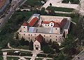
Thury Castle

Zichy Castle


literature
- András Gergelyffy: Várpalota , 1993
Web links
- City website
- Aerial views over Várpalota
- Illustration by Johan Sibmacher from 1665: True contrafactur of the occupation Palotta, und Vesperin In Ungern, Anno Christi 1593 Mense Octobris ( digitized version )
Individual evidence
- ↑ A MAGYAR KÖZTÁRSASÁG HELYSÉGNÉVTÁRA, 2009. Központi Statisztikai Hivatal (KSH).
- ^ Theodory Lavi (ed.): “Varpalota” - Encyclopedia of Jewish Communities in Hungary. Yad Vashem, Jerusalem 1975