
Connection arch (Vienna)
| Junction Nussdorfer Straße – Friedensbrücke | |||||||||||||||||||||||||||||||||||||||||||||||||||||||||||||||||||||||||||||||||||||||||||||||||||||||||||||||||||||||||||||||||||||||||||||||||||||||||||||||||||||||||||||||||||||||||||||||||||||||||||||||||||||||||||||||||||||||||||||||||||||||||||||
|---|---|---|---|---|---|---|---|---|---|---|---|---|---|---|---|---|---|---|---|---|---|---|---|---|---|---|---|---|---|---|---|---|---|---|---|---|---|---|---|---|---|---|---|---|---|---|---|---|---|---|---|---|---|---|---|---|---|---|---|---|---|---|---|---|---|---|---|---|---|---|---|---|---|---|---|---|---|---|---|---|---|---|---|---|---|---|---|---|---|---|---|---|---|---|---|---|---|---|---|---|---|---|---|---|---|---|---|---|---|---|---|---|---|---|---|---|---|---|---|---|---|---|---|---|---|---|---|---|---|---|---|---|---|---|---|---|---|---|---|---|---|---|---|---|---|---|---|---|---|---|---|---|---|---|---|---|---|---|---|---|---|---|---|---|---|---|---|---|---|---|---|---|---|---|---|---|---|---|---|---|---|---|---|---|---|---|---|---|---|---|---|---|---|---|---|---|---|---|---|---|---|---|---|---|---|---|---|---|---|---|---|---|---|---|---|---|---|---|---|---|---|---|---|---|---|---|---|---|---|---|---|---|---|---|---|---|---|---|---|---|---|---|---|---|---|---|---|---|---|---|---|---|---|
| Route length: | 1.415 km | ||||||||||||||||||||||||||||||||||||||||||||||||||||||||||||||||||||||||||||||||||||||||||||||||||||||||||||||||||||||||||||||||||||||||||||||||||||||||||||||||||||||||||||||||||||||||||||||||||||||||||||||||||||||||||||||||||||||||||||||||||||||||||||
| Gauge : | 1435 mm ( standard gauge ) | ||||||||||||||||||||||||||||||||||||||||||||||||||||||||||||||||||||||||||||||||||||||||||||||||||||||||||||||||||||||||||||||||||||||||||||||||||||||||||||||||||||||||||||||||||||||||||||||||||||||||||||||||||||||||||||||||||||||||||||||||||||||||||||
| Power system : | from 1925: 750 volts = | ||||||||||||||||||||||||||||||||||||||||||||||||||||||||||||||||||||||||||||||||||||||||||||||||||||||||||||||||||||||||||||||||||||||||||||||||||||||||||||||||||||||||||||||||||||||||||||||||||||||||||||||||||||||||||||||||||||||||||||||||||||||||||||
| Dual track : | continuous | ||||||||||||||||||||||||||||||||||||||||||||||||||||||||||||||||||||||||||||||||||||||||||||||||||||||||||||||||||||||||||||||||||||||||||||||||||||||||||||||||||||||||||||||||||||||||||||||||||||||||||||||||||||||||||||||||||||||||||||||||||||||||||||
|
|||||||||||||||||||||||||||||||||||||||||||||||||||||||||||||||||||||||||||||||||||||||||||||||||||||||||||||||||||||||||||||||||||||||||||||||||||||||||||||||||||||||||||||||||||||||||||||||||||||||||||||||||||||||||||||||||||||||||||||||||||||||||||||
The connecting curve , also known as the connecting curve, in the Vienna districts of Döbling and Alsergrund was a standard-gauge railway line between the former Nussdorfer Straße junction and the Friedensbrücke station , which was called Brigittabrücke until 1926 . The 1.415 kilometer long connecting curve linked the belt line (today U6) with the Danube Canal line (today U4) from 1901 to 1991 . The double-track elevated railway , originally licensed as a local railway , was built for the Vienna Steam City Railway on behalf of the Vienna Transport Systems Commission and was later taken over by the Vienna Electric Light Rail and the Vienna U-Bahn . Today the route is mostly closed, only a 300 meter long section is still used by the underground. The connecting arch was also the only section of the light rail that ran exclusively in an elevated position.
history

In the original urban railway plan of October 27, 1892, the connecting arch was not yet included. However, after the Gumpendorfer Straße - Matzleinsdorf section was omitted for reasons of cost in the course of concretising the project , this threatened to have a negative impact on future operations because the belt line from the main customs office could not have been reached without changing the direction of travel . In order to compensate for this shortcoming, those responsible therefore integrated the connecting arch into the final urban railway planning at short notice by law of 23 May 1896.
The cross bar was originally supposed to start directly at the Nußdorfer Straße station and be only 850 meters long. However, after the Danube Canal line was rescheduled from an elevated to an underground railway in 1898, the connecting arch could no longer lead to the belt line by the shortest route due to the lowering of its end point Brigittabrücke, i.e. in place of today's Nordbergbrücke, because otherwise the slope of the ramp to the bridge would have been too strong across the Franz-Josefs-Bahn . Instead, the planners artificially lengthened it to a bend that swept further north in order to achieve a more favorable gradient. However, the already built junction at the Nussdorfer Straße station was useless. This preliminary construction work in the area of the tram arches with the numbers 179–184 has been preserved to this day. As a substitute, the Nussdorfer Straße junction, located about 300 meters further in the direction of Heiligenstadt, was built on the open stretch, located at km 7.279 of the belt line.
Ultimately, the connecting arch with its 55 stone viaduct arches and six steel bridges went into operation on August 6, 1901, together with the Danube Canal line, with which the light rail network was complete. The kilometering followed that of the belt line , i.e. the Meidling-Hauptstraße station also served as the zero point . With the extensive cessation of operations due to a lack of coal on December 8, 1918, steam light rail traffic on the connecting arch also ended and the infrastructure was temporarily idle. It was only on 20 October 1925, the route went after electrification by the City of Vienna back in operation and was now on the lines operated DG towards Nußdorferstraße and GD toward Brigittabrücke. As a result of the Second World War , operations were suspended again from April 6 to July 18, 1945, and after being put back into operation, line G also served the connecting arch until 1954.
From October 7, 1989, the connecting arch - which, like the belt line, was switched from left-hand to right-hand drive in 1988 - was part of the U6 line, which emerged from the GD light rail line on that day. But on March 4, 1991, traffic on the connecting arch ended in order to be able to build the Vienna Spittelau traffic station. When it was completed on May 4, 1996, an approximately 300-meter-long section of the connecting arch that is now used by the U6 went back into operation. The disused section has been used as a pedestrian and cycle path since 2009 under the name Bertha-Zuckerkandl -Weg and is partially covered by the Zaha-Hadid-House, which was completed in 2005 . The single sheet 346 was the only one that was torn off.

In 1896 the connecting arch is still listed as a project and with the alignment that was later rejected

The connecting arch in the original plan as a direct connection between the Brigitta-Brücke and Nussdorfer-Str.

Originally the route was supposed to branch off on the left edge of the picture in front of the bridge over Döblinger Hauptstrasse, the preliminary construction work has been preserved to this day

At the Nussdorfer Straße junction, the connecting arch branched off to the right, straight ahead towards Heiligenstadt

Immediately after the Brigittabrücke station, the connecting arch began to rise, originally it was supposed to be in an elevated position
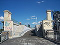
A pedestrian and cycle path now runs along the section that was closed in 1991

The section overbuilt by the Zaha Hadid House

The bridge over Heiligenstädter Straße is still in operation and is used by the U6


literature
- Alfred Horn: Wiener Stadtbahn. 90 years of light rail, 10 years of underground. Bohmann-Verlag, Vienna 1988, ISBN 3-7002-0678-X .
Web links
Individual evidence
- ^ Alfred Horn: 75 years of the Vienna light rail. "Between the 30s Bock and the Silver Arrow". Bohmann-Verlag, Vienna 1974, ISBN 3-7002-0415-9 , p. 295.