
Vienna Spittelau traffic station
| Vienna Spittelau stop | |
|---|---|
 ÖBB stop and subway area
|
|
| Data | |
| Operating point type | Through station |
| Platform tracks | 2 |
| abbreviation | Wf H1 ( ÖBB ), AU ( VOR ) |
| IBNR | 8101937 |
| opening | 1995-1996 |
| location | |
| City / municipality | Vienna |
| state | Vienna |
| Country | Austria |
| Coordinates | 48 ° 14 '8 " N , 16 ° 21' 29" E |
| Railway lines | |
| List of train stations in Austria | |
| Spittelau | |
|---|---|
|
|
|

|
|
| Access via the Skywalk Spittelau | |
| Basic data | |
| District : | Alsergrund |
| Coordinates : | 48 ° 14 ′ 8 " N , 16 ° 21 ′ 29" E |
| Opened: | 1995 |
| Tracks (platform): | 4 ( central platform , side platform ) |
| Station abbreviation: | AU |
| use | |
| Subway lines : |
|
| Transfer options : |
REX D 35A 37A N8 N35 N36 |
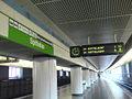
The Vienna Spittelau transport station is a multi-storey transfer hub in the 9th district of Alsergrund . It extends parallel to and over the tracks of the Franz-Josefs-Bahn. The node is one of the most important for the local public transport commuting from north-western Lower Austria and consists of the Wien Spittelau stop of the ÖBB and the Spittelau underground station of the Wiener Linien . The underground lines U4 and U6 meet in the traffic station . Regional trains of the Franz-Josefs-Bahn and trains of the S40 S-Bahn also stop here . It is also possible to change to tram line D and several bus routes.
prehistory

The Commission for Transport Systems in Vienna was planning a high-altitude Spittelau station for its Vienna steam light rail in the Althangrund area in the 1890s . It was planned between the Nussdorfer Straße and Heiligenstadt stops on the belt line, shortly after the Radlmayergasse joins Heiligenstädter Straße. Originally the station was to be called "Leibenfrostgasse", corresponding to the name of Radlmayergasse, which was valid until 1894. On the Danube Canal line, a stop called “Rampengasse”, sometimes also called “Spittelauer Lände”, was planned a little further north. In the course of the savings measures in the further project planning, both stations were canceled without replacement by a municipal council resolution in 1897.
General
The distinctive main building of the traffic station was only built when the connecting arch between Friedensbrücke and Nußdorfer Straße was closed , or when the north branch of the U6 to Floridsdorf opened in 1996. In earlier Vienna subway concepts, the traffic junction appeared under the name "Belt Cross" as early as the 1960s. The relocation of the Franz-Josefs-Bahnhof of the ÖBB to this location originally requested by the City of Vienna was not realized. On October 7, 1995, the U4 systems were released, and on May 4, 1996 the U6 section was opened. An office building, which opened in 2008 and can be reached directly via the Spittelau Skywalk, was integrated into the old - no longer used - tram arches west of the station . From the southern forecourt of the station, a pedestrian and cyclist path can be reached, which was built on the old route of the steam light rail or the Viennese electric light rail that emerged from it .
construction
The station is designed as a tower train station. The Franz-Josephs-Bahn and the U4, which run next to each other in the station area, each have a central platform at ground level. The U6, which is equipped with two side platforms, runs two floors further up. In between there is a distribution floor, via which all platforms can be reached by escalator , elevator and fixed stairs. There are also smaller shops such as a bookstore and a tobacco shop as well as several fast food shops. Exits lead from the distribution level to Heiligenstädter Strasse, Spittelauer Steg and via the Skywalk Spittelau to Guneschgasse; Furthermore, the ÖBB and U4 platforms have exits to Josef-Holaubek-Platz at the Spittelau waste incineration plant
The platforms of the U6 were at 13.5 meters above street level until the opening of the U2 - Stadlau station on October 2, 2010, the highest in the entire Vienna subway network.
Lines in the Verkehrsverbund Ost-Region
ÖBB regional transport
| line | course | Cycle (min) | Remarks |
|---|---|---|---|
| REX | Vienna Franz-Josefs-Bahnhof - Vienna Spittelau - Vienna Heiligenstadt - Absdorf-Hippersdorf - Sigmundsherberg - Gmünd - České Velenice | ≈60 / ≈120 (to Gmünd Lower Austria) | at peak times every 30/60 min in the load direction |
| REX | Vienna Franz-Josefs-Bahnhof - Vienna Spittelau - Vienna Heiligenstadt - Absdorf-Hippersdorf - Krems an der Donau | ≈60 | at peak times every 30 minutes in the load direction |
| Vienna Franz-Josefs-Bahnhof - Vienna Spittelau - Vienna Heiligenstadt - Klosterneuburg-Kierling - Tulln - Tullnerfeld - Herzogenburg - St. Pölten Hbf | ≈30 / ≈60 (to St. Pölten Hbf) | every 10/20 minutes to Kritzendorf at peak times; at the weekend only every 120 minutes to St. Pölten Hbf |
city traffic
gallery

Station building from the belt bridge

ÖBB platforms
Platforms of the U4

Platforms of the U6
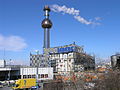
The Spittelau district heating plant south of the station

Upper entrance


Web links
Individual evidence
- ^ Pickaxe for the Franz-Josefs-Bahnhof , Arbeiterzeitung, August 7, 1968, accessed on September 12, 2010.
- ↑ UrbanRail.net Vienna
- ↑ Numbers data facts
| Previous station | S-Bahn Vienna | Next station |
|---|---|---|
|
Vienna Heiligenstadt ← St. Pölten Central Station |
|
Vienna Franz-Josefs-Bahnhof Vienna Franz-Josefs-Bahnhof → |
| Previous station | Vienna subway | Next station |
|---|---|---|
|
Friedensbrücke ← Hütteldorf |
|
Heiligenstadt Heiligenstadt → |
|
Nussdorfer Strasse ← Siebenhirten |
|
Jägerstrasse Floridsdorf → |