Vignemale
| Vignemale | ||
|---|---|---|
|
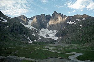
Vignemale from the Réfuge des Oulettes de Gaube: Piton Carré, Couloir de Gaube, Pique-Longue |
||
| height | 3298 m | |
| location | Border between Huesca , Aragon and the municipality of des Cauterets , France | |
| Mountains | Pyrenees | |
| Coordinates | 42 ° 46 '30 " N , 0 ° 8' 57" W | |
|
|
||
| First ascent | August 2, 1792 by unknown surveyor, October 8, 1837 Henri Cazaux, Bernard Guillembet |
|
| Normal way | Alpine tour (glaciated) | |
The Vignemale or Pico Viñamala is one of the approximately 200 over 3,000 meter high mountains in the Pyrenees . The 3298 m high summit of Pique-Longue is located on the border ridge between the Spanish province of Huesca in the north of the Aragon region and the municipality of des Cauterets in the French department of Hautes-Pyrénées .
Ascent
The starting point of the normal route for ascent of Vignemale is the Refuge de Bayssellance (2651 m) . From there, the path initially leads slightly downhill to the east, and branches off to the south in a hairpin (approx. 2520 m) from the HRP and GR 10 that run together here . The path quickly climbs along the Ossoue glacial streams and leads to the lower end of the Ossoue Glacier . Depending on the condition of the glacier, you can continue the path over the crevasse ( crampons and ice ax required) or continue south at the lower edge to the Crête Montferrat to bypass the glacier first. After crossing the Ossoue Glacier, there is still an easy climb to the summit (approx. Three hours from the Réfuge de Bayssellance).
![]()
The summit offers a view to the east of the ridge of the Cirque de Gavarnie and the massif of Monte Perdido , to the west of the Balaïtous and the Pic du Midi d'Ossau , to the north of the massif of Néouvielle and into the vast plains of France .
First ascent
On August 1, 1792, some shepherds noticed a signal from the summit of Pic de Montferrat , which was given by a group of surveyors. The surveyors, guided by geodesist Louis-Philippe Reinhart Junker, determined the course of the border and the height of the peaks. The next day, August 2nd, 1792, the same shepherds noticed a signal from the summit of Pique-Longue, the main summit of Vignemale. However, the names of the surveyors are not known.
The first recorded ascent then took place on October 8, 1837 by Henri Cazaux and Bernard Guillembet over the Ossoue Glacier. Since the two fell several times in crevasses during the ascent , they chose the western route over the rock pillars down into the Spanish Ara Valley to descend.
In the following year Anne Lister (1791–1840) led the first tourist ascent , led by Henri Cazaux and Bernard Guillembet as well as Jean-Pierre Charles and Jean-Pierre Sajous.
On August 7, 1889, the first ascent of the Vignemale through the Couloir de Gaube by Henri Brulle, Jean Bazillac, Célestin Passet, François Bernat-Salles and Roger de Monts followed.
First winter ascent
The first winter ascent took place on February 11, 1869 by the Pyrenean Count Henry Russell (1834-1909) led by the brothers Hyppolyte and Henri Passet from Gavarnie .


