
Vrokastro

Vrokastro ( Greek Βρόκαστρο ) is an archaeological excavation site in the northeast of the Greek island of Crete . It is located in the municipality of Agios Nikolaos in the Lasithi regional district about 1.9 kilometers east of Kalo Chorio near the Bay of Mirabello . The remains of settlements exposed at an altitude of around 270 to 313 meters above the village of Istro (Ίστρο) date from the Late Minoan and Geometric period from around 1200/1150 to 700 BC. Chr.
Location and history

Vrokastro is a shortened form of Evraiokastro (Ἑβραιόκαστρο, Hebrew fortress '). The excavation site is located on an elevation about 500 meters as the crow flies south of a small bay on the north coast of Crete, on which the beach Paralia Voulisma (Παραλία Βούλισμα) between the peninsulas Agios Pandeleimon (Άγιος Παντελεήμων) in the west and Elias to Nisi (ίΗττνας Ητisi Nisi) located in the east. It is divided into two excavation sections, called the Upper and Lower Town. The height difference of the lower town is about 20 meters, from about 270 to 290 meters, that of the upper town 55 meters to the south is 13 meters, from 300 meters to the top of the elevation at 313.1 meters.

Although finds in and around Vrokastro indicate an earlier settlement, the settlement found during the excavations existed from the late Minoan phase SM III C, the transition from the Bronze to the Iron Age , to the end of the geometric period of the so-called dark centuries . Richard Berry Seager and Harriet Boyd-Hawes visited the site as early as 1903 . First excavations took place in 1910 and 1912 under the direction of Edith Hayward Hall . Parts of the settlement that were uncovered in 1912 were not included in the published excavation report. A survey of the area was conducted in the 1980s and Barbara J. Hayden published a new map of the excavated foundations of the settlement buildings.
The 15,000 to 18,000 m² of the excavated settlement represent the size of the settlement in its late phase in the geometric period. From the beginning of settlement activity in the late Minoan period SM III C comes almost exclusively material that was found in backfills and pits. A floor level at this time could not be secured. It is believed that the early village was much smaller, so Krzysztof Nowicki estimates it to be around 7000 m². In the lower town, about twice as many rooms were uncovered from the late phase (63) than in the upper town with 31 rooms. In addition to single-room buildings, multi-room structures in rectangular form were also found. The largest building with 6.5 × 12 meters, probably a purely cult building due to the figurines found here, was in the upper town.
The two parts of the settlement were built in an agglutinating manner. In addition to the adjoining buildings, there are also some small paths and courtyards. In the north of the lower town remains of a wall 1 to 1.5 meters thick were discovered in places. Barbara J. Hayden considers them multifunctional, not just to fortify the settlement. Due to its strategically favorable position, Vrokastro served as a refuge as well as, together with Elias to Nisi in the northeast and Agios Phanourios in the east, as a settlement center between Agios Nikolaos and the isthmus of Ierapetra in geometric time. In the immediate vicinity of Vrokastro, some graves were discovered, but they could not be clearly assigned to the settlement.
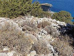
- Excavation site

Room 21 of the upper town

Room 34 of the upper town
Room 4 of the lower town

Eastern Lower City


literature
- Edith Hayward Hall : Excavations in Eastern Crete: Vrokastro (= The Museum Anthropological Publications . No. 3 ). University of Pennsylvania, Philadelphia 1914 ( digitized version ).
.jpg)
- Barbara J. Hayden, Jennifer A. Moody: The Vrokastro Survey Project. In: Expedition Magazine. Volume 32,3 (1990), pp. 42-53 ( PDF ).
- Barbara J. Hayden: Terracotta Figures, Figurines, and Vase Attachments from Vrokastro, Crete. In: Hesperia . Volume 60, No. 1 (1991), pp. 103-144 ( PDF; 8585.15 KB ).
- Barbara J. Hayden, Jennifer A. Moody, Oliver Rackham: The Vrokastro Survey Project, 1986–1989. In: Hesperia. Volume 61, No. 3 (1992), pp. 293-353 ( PDF; 10246.17 KB ).
- Barbara J. Hayden: Final Neolithic-Early Minoan I / IIA Settlement in the Vrokastro Area, Eastern Crete. In: American Journal of Archeology. Volume 107, Number 3 (2003), pp. 363-412 ( JSTOR 40025393 ).
- Barbara J. Hayden: The Final Neolithic-Early Minoan I / IIA Settlement History of the Vrokastro Area, Mirabello, Eastern Crete. In: Mediterranean Archeology and Archaeometry. Volume 3 (2003), pp. 31-44 ( PDF ( Memento from September 28, 2013 in the Internet Archive )).
- Marina Gkiasta: The Historiography of Landscape Research on Crete . Leiden University Press, Leiden 2008, pp. 122-125 ( PDF; 4173.82 KB ).
Individual evidence
- ↑ Edith Hayward Hall : Excavations in Eastern Crete: Vrokastro (= The Museum Anthropological Publications . No. 3 ). University of Pennsylvania, Philadelphia 1914 ( digitized version ).
- ↑ Sebastian Zöller: The society of the early "dark centuries" on Crete. An examination of the archaeological legacies of the population of Crete during the Late Minoan IIIC and Sub-Minoan Periods in terms of their social significance and significance. Master's thesis, Ruprecht-Karls-Universität Heidelberg 2005, panel 27 f. ( PDF of the blackboard section; 8.6 MB ).
- ^ Barbara J. Hayden: New Plans of the Early Iron Age Settlement of Vrokastro. In: Hesperia . Volume 52, No. 4 (1983), pp. 379-380 ( PDF; 4068.14 KB ).
- ^ Barbara J. Hayden: New Plans of the Early Iron Age Settlement of Vrokastro. In: Hesperia . Volume 52, No. 4 (1983), p. 372 ( PDF; 4068.14 KB ).
- ^ A b c Sebastian Zöller: The society of the early "dark centuries" on Crete. Master's thesis, Ruprecht-Karls-Universität Heidelberg 2005, p. 72 ( PDF; 1391.54 KB ).
- ^ Barbara J. Hayden: New Plans of the Early Iron Age Settlement of Vrokastro. In: Hesperia . Volume 52, No. 4 (1983), p. 367 ( PDF; 4068.14 KB ).
- ↑ a b Sebastian Zöller: The society of the early "dark centuries" on Crete. Master's thesis, Ruprecht-Karls-Universität Heidelberg 2005, p. 73 ( PDF; 1391.54 KB ).
- ↑ Sebastian Zöller: The society of the early "dark centuries" on Crete. Master's thesis, Ruprecht-Karls-Universität Heidelberg 2005, pp. 74–75 ( PDF; 1391.54 KB ).
Web links
- Vrokastro. (PDF) Location and plan. Heidelberg University, accessed on January 3, 2017 .
- Barbara J. Hayden, Jennifer A. Moody: The Vrokastro Survey Project. Penn Museum, 2013, accessed January 3, 2017 .
Coordinates: 35 ° 7 ′ 13 ″ N , 25 ° 44 ′ 41.6 ″ E