
Vuurtoren aan de Maasvlakte
| Vuurtoren aan de Maasvlakte | ||
|---|---|---|
 |
||
| Place: |
|
|
| Location: | Zuid-Holland , Netherlands | |
| Geographical location: | 51 ° 58 '12.2 " N , 4 ° 0' 51.4" E | |
| Fire carrier height : | 65 m | |
|
||
| Optics: | Fresnel lens | |
| Function: | Radar tower | |
| Construction time: | 1974 | |
| Operating time: | 1974-2008 | |

The Vuurtoren aan de Maasvlakte ( German lighthouse on the Meuse plain ) is a former lighthouse on the west side of the Maas estuary in the Dutch province of South Holland .
Building
The lighthouse on the Dutch Meuse plain was designed by W. Colenbrander and built in 1974. The octagonal concrete tower is 65 meters high, making it the highest lighthouse in the Netherlands. It was built to mark the entrance to the Nieuwe Waterweg and the Europoort behind it . Its construction made two previous lighthouses in Hoek van Holland superfluous. Today the tower is only used as a support for a radar device ; the beacon was deactivated on October 8, 2008.
beacon
The beacon, which was shut down in 2008, came from the shut down lighthouse De Hoge Licht in Hoek van Holland and had a light intensity of 2,500,000 candelas and reached a distance of 28 nautical miles . The light was identified by five light signals in a 20-second interval: "Fl (5), 20s, 28S".
See also
photos
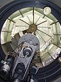
View from below into the beacon

View from the lighthouse

