Gruberwand
| Gruberwand | ||
|---|---|---|
|
Weekly with a large tidal channel in the background |
||
| height | 2049 m above sea level A. | |
| location | Upper Austria , Austria | |
| Mountains | Dead Mountains | |
| Dominance | 0.37 km → Schwarzkogel | |
| Notch height | 39 m | |
| Coordinates | 47 ° 44 '9 " N , 14 ° 6' 43" E | |
|
|
||
| rock | Banked Dachstein limestone | |
| Age of the rock | Norium - Rhaetium | |
| Normal way | from Hinterstoder over the Prielergraben and small priel | |
|
Small creek seen from Vorderstoder . |
||
The Wöchana is a 2049 m above sea level. A. high mountain in the Dead Mountains in Upper Austria's Traunviertel .
Location and structure
The mountain, made of Dachstein limestone , is embedded between the fishing wall in the west and the Schwarzkogel in the east and lies in the Prielgruppe at an altitude of over 2000 m on the border between the communities of Hinterstoder and Klaus an der Pyhrnbahn . It is part of a ridge that extends from the Großer Priel towards the east and is bordered by the Stodertal in the south and by the Steyrlingtal and Weißenbachtal in the north .
rise
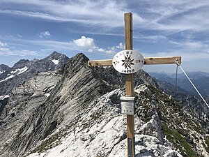
The ascent takes place first on the marked path no. 269 from the center of Hinterstoder over the Prielergraben to the small priel in four and a half hours. The further route leads over a seldom used and lengthy crossing, the so-called Priel crossing , past the Schwarzkogel ( 2091 m ). From the summit of the Kleiner Priel, the Wöchana can be reached in 2 hours. Since July 2019, the Wöchana has been adorned with the mightiest summit cross on the entire ridge.
The crossing then leads to the Angelmauer ( 2102 m ), the Teufelsmauer ( 2185 m ) and the Kirtagmauer ( 2144 m ) to the Arzlochscharte and from there over the Priel north ridge to the summit of the Großer Priel. This crossing, a ridge hike with many but short climbing sections up to difficulty level II ( UIAA ), was carried out for the first time in 1904 by O. Gruber and H. Schmid. Due to the length of the tour and the ascent and descent, which should not be underestimated, a bivouac is to be expected.
cards
- Alpine Club Map Bl. 15/2 (Dead Mountains - Center), 1: 25,000; Austrian Alpine Club 2008; ISBN 978-3-928777-31-5 .
- ÖK 50, sheet 98 (Liezen), 1: 50,000.
literature
- Gisbert Rabeder: Dead Mountains. Alpine club guide for hikers, mountaineers and climbers. 4th, revised edition. Bergverlag Rother, Munich 2005, ISBN 3-7633-1244-7 .
Web links
Individual evidence
- ^ Federal Office for Metrology and Surveying Austria: Austrian Map online (Austrian map 1: 50,000) .
- ↑ alpintouren.com: From Hinterstoder to the Kleine Priel, 2134m / hiking tour
- ↑ Ludwig Krenmayr, Gernot Rabeder, Gisbert Rabeder: Alpenvereinsführer Totes Gebirge (= Alpine Club Leader. Series: Northern Limestone Alps ). RZ 60–63 and 155–157. 3rd, revised edition. Bergverlag Rudolf Rother, Munich 1982, ISBN 3-7633-1244-7 , margin number 334


