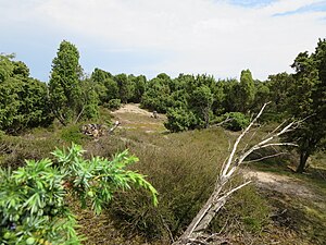
Juniper Heath (Lingen)
|
Juniper heather
|
||
| location | West of Lingen , southwest of Geeste | |
| surface | 23 hectares | |
| Identifier | NSG WE 163 | |
| WDPA ID | 378716 | |
| Geographical location | 52 ° 33 ' N , 7 ° 15' E | |
|
|
||
| Sea level | from 20 m to 26 m | |
| Setup date | 09/21/1985 | |
| administration | NLWKN | |
The juniper heather is a nature reserve in the Lower Saxon town of Lingen (Ems) in the Emsland district .
The nature reserve with the sign NSG WE 163 is 23 hectares in size. It is fully part of the FFH area "Ems" and mostly from the conservation area surrounded "Emstal". The area has been a nature reserve since September 21, 1985. The responsible lower nature conservation authority is the city of Lingen (Ems).
The nature reserve consists of two parts and is located in the northwest of Lingen. It places a remnant of an inland dune and heathland with junipers under protection, as it was characteristic of the Emsland in the 18th and 19th centuries . The heathland was created through the historical use of the areas. The original birch and oak forests were cleared and the areas grazed.
To prevent the heather from overgrowing, the nature reserve is still grazed with sheep today.
Web links
- Nature reserve "Wacholderheide (Lingen)" in the database of the Lower Saxony State Office for Water Management, Coastal and Nature Conservation (NLWKN)
Individual evidence
- ↑ heath hike , home Lingen (accessed on 31 May 2011).
- ^ City of Lingen: Excursion to the Wachendorfer Wacholderheiden , Lower Saxony State Agency for Water Management, Coastal and Nature Conservation , November 30, 2010 (accessed May 31, 2011).


