Wadebridge
|
Wadebridge Cornish Ponsrys |
|||
|---|---|---|---|
|
|||
| Coordinates | 50 ° 31 ′ N , 4 ° 50 ′ W | ||
|
|
|||
| Residents | 6351 | ||
| administration | |||
| Post town | WADEBRIDGE | ||
| ZIP code section | PL27 | ||
| prefix | 01208 | ||
| Part of the country | England | ||
| region | South West England | ||
| Ceremonial county | Cornwall | ||
| Website: Wadebridge Town Council | |||
Wadebridge ( Cornish Ponsrys ; "ford bridge") is a town in the north of the English county of Cornwall . It was the administrative seat of the 1195.17 km² former district of North Cornwall with 86,300 inhabitants (2007). The city itself has 6351 inhabitants (2001).
geography
location
Wadebridge is located at the southeastern beginning of the estuary of the River Camel , which rises northeast of the city of Camelford and flows into the Atlantic Ocean at Trebetherick between Pentire Point and Stepper Point on Padstow Bay . The highest level of the tidal current of the Atlantic reaches close to the eastern edge of the urban area of Wadebridge near the Egloshayle district. At low tide ( ebb ) the river falls almost dry, so that it is then not navigable .
The open sea of the Atlantic Ocean begins ten kilometers northwest of central Wadebridge. The small town of Padstow is located near the mouth of the Camel , about eight kilometers from Wadebridge. Other nearby towns are Bodmin , five miles to the southeast, and Camelford, fourteen kilometers to the northeast. The county capital of Cornwall, Truro , is 20 miles from Wadebridge and is southwest of the city.
City structure
The town of Wadebridge consists of the districts of St. Breock, Trevanson, Guineaport, Wade, Whiterock and Egloshayle.
climate
In Wadebridge, as in all of Cornwall, there is a maritime temperate climate, with it being humid all year round and the winters being particularly mild.
history
One of the first mentions of Wadebridge, as a market settlement Wade (from Old English wyeth for " ford "), comes from the year 1313. At that time, today's urban area belonged to the parishes of Egloshayle and St. Breock on both sides of the Camel River , each with its own churches. St. Michael's on the west side and King's chapel east of the river.
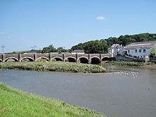
In 1468, at the instigation of the parish priest of Egloshayle, Thomas Lovibond, The Old Bridge was completed, financed by the farmers' profits from the sale of the sheep's wool produced in the area at the wool market in Wade . The 320- foot (97.5-meter) long stone bridge, built on 17 arches, gave its name to the place now called Wadebridge. Today the bridge only consists of 14 arches.
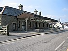
From September 30, 1834, Wadebridge had a railway connection along the Camel upstream via Boscarne to Wenfordbridge with a branch to Bodmin. According to an 1831 study initiated by Pencarrow's local landowner Sir William Molesworth, the railway was built at a cost of £ 35,000 . The Bodmin & Wadebridge Railway was Cornwall's first public rail line and one of the first in the world, opening nine years after the first steam-powered passenger railroad, the Stockton & Darlington Railway, in north-east England .
On the Bodmin & Wadebridge Railway , sand was initially transported inland from the Camel estuary as fertilizer . After the purchase by the London & South Western Railway and the expansion of the route network in the 19th century, the railway line in Wadebridge was closed to passenger traffic on January 30, 1967. Today the Camel Trail runs along the route of the former railway line , a 17.3- mile (27.8-kilometer) hiking and biking trail.
The town hall was built between 1886 and 1888 and opened on May 31, 1888. The cost of £ 3,000 was paid by Sir Paul Molesworth, which is why the house, initially used by the city and later by the community, was initially called Molesworth Hall . At the back of the Town Hall is a mural painted by V. Harvey of St. Mabyn , depicting the construction of the Old Bridge .
Attractions
- Parish church St. Breock in the district of the same name.
- The stone row Nine maidens stands in a field east of the A39 south of Wadebridge.
supporting documents
- ^ Civil Parish, 2001
- ↑ a b c Wadebridge - North Cornwall
- ^ Wadebridge Town Council Home
- ^ The History of the Railway in Bodmin
- ↑ The Camel Trail on the Cornwall Administration website, accessed April 3, 2018.


