Waitara (New Zealand)
| Waitara | ||
| Geographical location | ||
|
|
||
| Coordinates | 39 ° 0 ′ S , 174 ° 14 ′ E | |
| Region ISO | NZ-TKI | |
| Country |
|
|
| region | Taranaki | |
| District | New Plymouth District | |
| Ward | North Ward | |
| Residents | 6th 483 (2013) | |
| height | 5 m | |
| Post Code | 4320 | |
| Telephone code | +64 (0) 6 | |
| UN / LOCODE | NZ WTA | |
| Photography of the place | ||
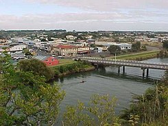
 View from the Waitara River to the west |
||
Waitara is a city in the New Plymouth District of the Taranaki regionon the North Island of New Zealand .
geography
The city is located about 15 km east-northeast of downtown New Plymouth at the confluence of the Waitara River in the Tasman Sea . The river divides the city in half, with the city center on the west side of the river. A single inner-city bridge connects the two parts of the city. The New Zealand State Highway 3 , which connects the city directly with New Plymouth , runs past the southern edge of Waitara . A branch of the railway connection Marton – New Plymouth Line leads about 5.5 km southwest of Sentry Hill from to Waitara and ends in the western part of the city.
history
Even before the arrival of European immigrants, the area around the Waitara River was densely populated and fought over by Māori tribes, as evidenced by the remains of numerous fortifications in the area. In the 1820s, the Ngati Awa moved to the Wellington area after being harassed by the Waikato tribes . In 1848 they returned to the Waitara River and were successful in farming and trading with European settlers who had settled in New Plymouth . Tensions between Māori and European settlers over land purchases finally led to the First Taranaki War on March 17, 1880 . With the end of the fighting and the capture of the last fortifications held by Māori , the tribes of the area were disempowered. The first European settlers settled in the area in 1867.
population
In the 2013 census, the town had 6,483 inhabitants, 3.1% more than in the 2006 census.
economy
The main source of income in the region around Waitara is, besides sheep breeding, the dairy industry. In the city itself there are companies that produce frozen food and spare parts for cars, as well as some carpentry shops.
See also
literature
- Helga Neubauer: Waitara . In: The New Zealand Book . 1st edition. NZ Visitor Publications , Nelson 2003, ISBN 1-877339-00-8 , pp. 432 f .
Web links
Individual evidence
-
↑ a b
Source population of Waitara West and East :
- 2013 Census QuickStats about a place : Waitara West . Statistics New Zealand,accessed October 25, 2017.
- 2013 Census QuickStats about a place : Waitara East . Statistics New Zealand,accessed October 25, 2017.
- ↑ Topo250 maps . Land Information New Zealand , accessed October 25, 2017 .
- ^ Neubauer: Waitara . In: The New Zealand Book . 2003, p. 433 .
- ^ Neubauer: Waitara . In: The New Zealand Book . 2003, p. 432 .

