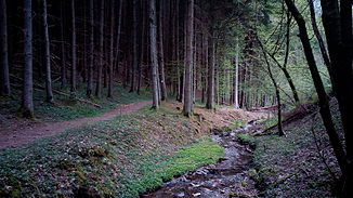
Waldbach (Ruwer, Gusterath)
| Waldbach | ||
|
The Gusterather Waldbach in spring 2014 |
||
| Data | ||
| Water code | DE : 265676 | |
| location | Rhineland-Palatinate | |
| River system | Rhine | |
| Drain over | Ruwer → Moselle → Rhine → North Sea | |
| source | Municipality of Gusterath 49 ° 42 ′ 27 ″ N , 6 ° 42 ′ 22 ″ E |
|
| Source height | 360 m above sea level NHN | |
| muzzle | at Gusterath-Tal in the Ruwer coordinates: 49 ° 42 '29 " N , 6 ° 43' 53" E 49 ° 42 '29 " N , 6 ° 43' 53" E |
|
| Mouth height | 197 m above sea level NHN | |
| Height difference | 163 m | |
| Bottom slope | 68 ‰ | |
| length | 2.4 km | |
| Catchment area | 2.563 km² | |
The Waldbach is a 2.4 km long, left tributary of the Ruwer in Rhineland-Palatinate , Germany with a catchment area of 2.6 km². It rises in the community of Gusterath at 360 m above sea level. NHN and flows into the Gusterath valley at 197 m .
A left tributary of the Gusterather Waldbach is the Anzenbach.
The Romika path leads along the banks of the forest stream from Gusterath valley to the Gusterath grill hut. He is one of the around the Saar-Hunsrück Climb located Traumschleifen .
Individual evidence
- ↑ a b Topographic map 1: 25,000
- ↑ a b GeoExplorer of the Rhineland-Palatinate Water Management Authority ( information )
- ↑ Dream loop Romikaweg. (PDF) In: Holidays in the Hunsrück - hiking, cycling, experiencing nature and culture. Hunsrück-Touristik GmbH, accessed on November 30, 2015 .
