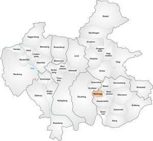
Waldegg (Winterthur)
|
Waldegg quarter of Winterthur |
|
|---|---|
| Coordinates | 699.2 thousand / 260003 |
| height | 454 m |
| surface | 0.39 km² |
| Residents | 1282 (Dec. 31, 2019) |
| Population density | 3287 inhabitants / km² |
| BFS no. | 230-320 |
| Post Code | 8405 |
| Urban district | Lakes (District 3) |
Waldegg is a district of the city of Winterthur in the Swiss canton of Zurich , which belongs to the urban district 3 ( lakes ).
geography
The quarter is west of the Seem town center. The Tösstalstrasse formed the border to the Waser district in the northwest and the Ganzenbühl district to the southeast , the border of which runs along the Steinackerweg, Hermannstrasse and Bühlackerstrasse. After the Pünten in the north-west of Waldegg, the Endliker district borders in the Mattenbach district ; on the edge of the Eschenberg Forest, the district also has a border with the Deutweg district , which also belongs to Mattenbach.
Mattenbach , which has overturned in the center of Seem , comes to the surface again on Heinrich-Bosshard-Strasse.
education
The primary school and the Steinacker kindergarten are in the center of the quarter, while the Waldegg kindergarten, which also belongs to the school, is in the south of the quarter. The secondary school is attended by the students in the Büelwiesen school building in the center of Seen.
population
At 30%, the proportion of people over 65 is twice as high as the urban average of 15%, it is the district with the highest proportion of people in this age group, but the proportion of the working population group from 20 to 64 with 53, 7% the lowest in the city (average: 65.4%). The proportion of foreigners in the quarter is 23%, which is below the urban average.
history
The area of the quarter, although close to it, does not belong to the original lakes settlement area. Waldegg was built in the late 1960s with a medium-sized development along Waldeggstrasse and Heinrich-Bosshardstrasse with a maximum of four floors. This contrasted with the urban development in the Waser quarter, which was being built on the other side of Tösstalstrasse at the same time. In the spring of 1976, the Steinacker school building in the neighborhood was opened and, thanks to prefabricated building elements, it took only 13 months to build. Later, single-family houses were built along the edge of the settlement, also emphasizing the character of the quarter.
Transport links
The district is served along Tösstalstrasse by trolleybus line 2 (Wülflingen – HB – Seen) from Stadtbus Winterthur , whose stops “Waldegg” and “Hinterdorf Seen” are on the edge of the district.
Web links
Individual evidence
- ↑ Statistical quarterly mirror 2016 (PDF; 1.13 MB) (No longer available online.) City of Winterthur, urban development, archived from the original on February 19, 2017 ; accessed on September 28, 2017 . Info: The archive link was inserted automatically and has not yet been checked. Please check the original and archive link according to the instructions and then remove this notice.
- ^ Adrian Mebold: From farming village to living and sleeping city without a center . In: Stadtbibliothek Winterthur (Ed.): Seen in der Neuzeit (= New Year's Gazette of the Stadtbibliothek Winterthur . Volume 342 ). Winterthur 2009, ISBN 978-3-908050-30-8 , pp. 58 .
- ^ Verena Rothenbühler: Village schools and educational institutes - schoolhouse stories . In: Stadtbibliothek Winterthur (Ed.): Seen in der Neuzeit (= New Year's Gazette of the Stadtbibliothek Winterthur . Volume 342 ). Winterthur 2009, ISBN 978-3-908050-30-8 , pp. 187 .


