
Walt Whitman Bridge
Coordinates: 39 ° 54 ′ 19 ″ N , 75 ° 7 ′ 47 ″ W.
| Walt Whitman Bridge | ||
|---|---|---|
 |
||
| use |
|
|
| Crossing of | Delaware River | |
| place | South Philadelphia ( Philadelphia ), PA and Gloucester City , NJ | |
| Entertained by | Delaware River Port Authority | |
| construction | Suspension bridge | |
| overall length | 3,652 m | |
| width | 28 m | |
| Longest span | 610 m | |
| Clear height | 46 m ( MHW ) | |
| building-costs | 90 million US dollars | |
| start of building | 1952 | |
| completion | 1957 | |
| planner | Ammann & Whitney Modjeski & Masters |
|
| location | ||
|
||
| in Pennsylvania (above) and Philadelphia (below) | ||
 Betsy Ross Bridge (top) |
||

The Walt Whitman Bridge is a seven-lane road bridge over the Delaware River between the borough of South Philadelphia in Pennsylvania and the city of Gloucester City in New Jersey . It runs Interstate 76 , which is connected to Interstate 95 in Pennsylvania and Interstate 676 in New Jersey . The bridge is operated by the Delaware River Port Authority and is toll road going west into Philadelphia . The average traffic volume is around 120,000 vehicles per day and can increase to 150,000 at peak times on summer weekends.
The suspension bridge designed with the participation of Othmar Ammann - with an average span of 610 meters - was one of the world's largest bridges of this type when it was completed in 1957 and was still one of the 100 longest suspension bridges in 2018 . It is named after the American poet Walt Whitman , who spent the last two decades of his life in neighboring Camden .
history
Planning and construction
The first ideas for a second river crossing in the south of Philadelphia emerged shortly after the opening of the Benjamin Franklin Bridge in 1926. In the 1930s, plans were drawn up for tunnel and bridge projects, the financing and construction of which was never implemented due to the outbreak of World War II . In the early 1950s, the Benjamin Franklin Bridge reached its capacity limit with 75,000 vehicles per day, whereupon the newly created seaport authority ( Delaware River Port Authority ) was commissioned to implement an additional river crossing. She favored a bridge over a tunnel solution, was finally able to prevail and in 1952 received approval for construction from the United States Army Corps of Engineers . The first test drillings were carried out in September 1952 and construction work on the pylons and anchor blocks could begin in the summer of 1953. The tensioning of the suspension cables began in 1955, followed by the installation of the track girder one year later. The new bridge was officially inaugurated on May 15, 1957 and opened to traffic one day later. The construction costs at that time amounted to 90 million US dollars .
With Othmar Ammann (Ammann & Whitney) and Frank M. Masters (Modjeski & Masters) , two experienced bridge construction engineers who are well-known beyond the USA were involved in the planning and design. Ammann had u. a. the George Washington Bridge (1931) built and Masters worked since 1904 under Ralph Modjeski , who u. a. was responsible for the neighboring Benjamin Franklin Bridge (1926). Both later became partners, the joint company Modjeski and Masters still exists today and is still active in the construction and maintenance of bridges.

The bridge from Philadelphia (left) to Gloucester City in NJ (right) with Camden in the background (2006)


Repair work
The first major overhaul of the bridge took place in the 1990s. Among other things, the roadways were repaired and widened from a total of 24 m to over 25 m. In addition, all load-bearing elements were examined for signs of fatigue and the bridge was adapted to the current earthquake safety standards . Tolls are incurred for use going west to Philadelphia (the opposite direction is toll-free), the introduction of the electronic toll system E-ZPass took place at the end of 1999. In the following year, a movable central partition (road zipper) was installed , which, depending on the direction of traffic, has a special barrier Transfer Machine can be moved.
After more than 50 years of operation, the reinforced concrete layer on the deck of the suspension bridge was replaced in 2011 . The work was carried out by the American Bridge Company , which had already installed the original road surface. In order to be able to carry out the work during ongoing operations, three gantry cranes spanning the girder were used, which made it possible to close one lane at peak times. In the course of the repairs, the side guardrails and the central partition wall were replaced, and bearings and expansion joints were replaced. The work was completed in spring 2014 and the costs amounted to 130 million US dollars.

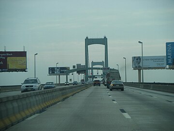
Access to the bridge in South Philadelphia (from left to right, I-76) with the center of the toll motorway triangle , extends from top to bottom the I-95 (1975)
Driveway to the east to New Jersey , on the left the movable central partition wall (2008)


description
The bridge with a total length of 3,652 m is divided into the main part designed as a suspension bridge , followed by the access roads, which consist of several truss girders with an overhead carriageway as well as a large number of girder bridges connected to them . The total length on both sides of the suspension bridge is 2,573 m. On the Philadelhpia side, the driveway is part of the Interstate 76 and Interstate 95 triangle , at the center of which is the toll station. On the Gloucester City side in New Jersey, the entrances merge into the interstate with Interstate 676 .
The actual suspension bridge is 1,079 m long and has a three-part 28 m wide deck that is hinged to the pylons . The middle steel lattice girder has a span of 610 m, the side girders between the pylons and the respective anchor block 235 m. At mean flood (MHW), the clear height below the carriageway girder is 46 m. The pylons are also made of steel, have a height of 115 m above MHW and rest on reinforced concrete foundations with a base area of 53 m × 20 m, some of which were built to a depth of 30 m. The 1.3 km long suspension cables run over the pylons have a diameter of 59 cm and consist of individual 5 mm steel wires, the ends of which are attached to the anchor blocks, which also form the abutments of the suspension bridge. These have a base area of 61 m × 37 m, a height of almost 40 m and have foundations down to a depth of 18 m.

Access with anchor block on the Philadelphia side (2010)


Web links
- Walt Whitman Bridge. Delaware River Port Authority.
- Sara Martino: Former Westville Mayor Reflects on His Memory of the Walt Whitman Bridge. ClearysNoteBook (CNBnews.net) May 15, 2007.
Individual evidence
- ^ A b Steven M. Richman: The Bridges of New Jersey: Portraits of Garden State Crossings. Rutgers University Press, 2005, ISBN 978-0813537825 , pp. 125-127.
- ↑ a b c d Walt Whitman Bridge (I-76) - Historic Overview. PhillyRoads.com from Eastern Roads, Inc. Retrieved January 13, 2018.
- ↑ Frank Griggs: Ralph Modjeski. In: STRUCTURE magazine. January 2013. Retrieved January 14, 2018.
- ↑ Jozef Glomb, Peter J. Obst (trans.): A man who spanned two eras: The story of bridge engineer Ralph Modjeski. The Philadelphia Chapter of the Kosciuszko Foundation, 2002, ISBN 0-917004-25-6 , p. 45.
- ↑ We do the right thing. Modjeski and Masters. Retrieved January 14, 2018.
- ^ Walt Whitman Bridge Suspension and Anchorage Spans Deck Replacement. American Bridge Co. Retrieved January 14, 2018.
- ↑ Walt Whitman Bridge receives new steel grid deck system. Case Studies, Roads & Bridges, 2013. Retrieved January 14, 2018.
|
Upstream RiverLink Ferry |
Crossing the Delaware River |
Downriver Commodore Barry Bridge |