Wistful
| Wistful | ||
|
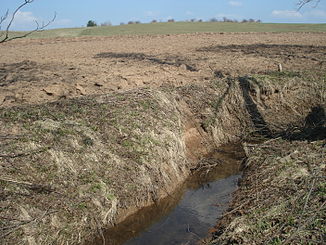
The Wehmig south of Neuses |
||
| Data | ||
| location |
Spessart
|
|
| River system | Rhine | |
| Drain over | Weibersbach → Kahl → Main → Rhine → North Sea | |
| source | at Metzkopf in the Sülzert 50 ° 6 ′ 45 ″ N , 9 ° 9 ′ 13 ″ E |
|
| Source height | 281 m above sea level NHN | |
| confluence | with the Eichbach to the Weibersbach , in Albstadt coordinates: 50 ° 7 '6 " N , 9 ° 6' 58" E 50 ° 7 '6 " N , 9 ° 6' 58" E |
|
| Mouth height | 160 m above sea level NHN | |
| Height difference | 121 m | |
| Bottom slope | 38 ‰ | |
| length | 3.2 km | |
| Catchment area | 3.4 km² | |
| Left tributaries | Ruhgraben | |
The Wehmig or the Wehmigbach is the left source brook of the Weibersbach in the district of Aschaffenburg in the Bavarian Spessart .
geography
course
The Wehmig rises at the Metzkopf (351 m) in the Bavarian Sülzert and flows in a westerly direction. It takes on the Ruhgraben , feeds some fish ponds at the tennis facilities south of Neuses and flows towards Albstadt . There it unites with the shorter and less watery Eichbach to form the Weibersbach .
Tributaries
- Ruhgraben (left)
Kahl river system
See also
Web links
Commons : Wehmig - Collection of images, videos and audio files

