
Weilbacher gravel pits

The Weilbacher gravel pits are former gravel pits in Weilbach , now renatured and partially designated as a nature reserve. The regional park portal to the Rhine-Main regional park has now also been built .
history

At the end of the 1970s, the Weilbacher gravel pits represented a landscape characterized by disorderly gravel mining . They were used as a wild garbage dump and for motocross races. In 1980 the city of Flörsheim , the Main-Taunus-Kreis and the then surrounding association of Frankfurt (today Regional Association FrankfurtRheinMain ) founded the Society for the Recultivation of the Gravel Pit Landscape Weilbach mbH (GRKW) in order to remedy this landscape damage through sensible recultivation . The cities of Hattersheim (1993) and Hochheim (2000) later joined the company. In 1991 the nature reserve Weilbacher Kiesgruben was opened, which is an important environmental education facility in the Rhine-Main area .
Regional park portal

In 2011 the regional park portal for the Rhine-Main regional park was opened. In addition to the visitor center with the adjoining restaurant “Zum Wilden Esel”, one of the most visually striking innovations is the regional park tower , a 41 meter high observation tower that was opened in June 2012 and was designed by the architect Peter Karle .
Sub-areas
To the north-east of the visitor center is a walk-in nature education area , in which numerous wet and dry biotopes as well as a geological window with views of the layers of the gravel mining area can be explored. South of the center there is a local recreation area with leisure facilities, the regional park tower and a number of walking paths.
Nature reserve
|
"Weilbacher Kiesgruben" nature reserve
|
||
| location | Hessen , Germany | |
| surface | 57,594 ha | |
| Identifier | 1436005 | |
| WDPA ID | 166216 | |
| Geographical location | 50 ° 3 ' N , 8 ° 27' E | |
|
||
| Setup date | 1986 | |
| Legal basis | Ordinance on the “Weilbacher Kiesgruben” nature reserve of April 20, 1986 | |

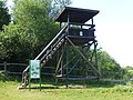
Most of the gravel pit landscape is taken up by the nature reserve around the Silbersee lake in the southeast. Cashmere goats and kulans are used to maintain the landscape . The semi-wild attitude of this endangered Asian half ass subspecies is unique in Europe. On the edge of the fenced area there are five wooden observation towers that offer a good view of the semi-open landscape. Information boards next to the towers explain the special features of each location.
photos

Site plan of the Weilbacher gravel pits
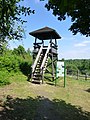
Observation tower 1 within the nature reserve

Lookout tower 1, view with goats

Lookout tower 2 on the northwestern edge

Lookout tower 3 on the north-northeast edge

View from observation tower 4 of the Silbersee
Lookout tower 5 on the southwestern edge of the nature reserve


Web links
Individual evidence
- ↑ Interactive map - virtual tour on the website of the Society for the Recultivation of the Gravel Pit Landscape Weilbach mbH - GRKW
swell
- "Bud at a height of 40 meters"; in: FAZ of July 16, 2011, page 54