Weissenstein (Jura)
| Weissenstein | ||
|---|---|---|
|
Solothurn's old town with the Weissenstein as a backdrop, March 2005 |
||
| Highest peak | Röti ( 1395.2 m above sea level ) | |
| location | Canton of Solothurn , Switzerland | |
| part of | law | |
|
|
||
| Coordinates | 607 169 / 233236 | |
| Type | Fold Mountains | |
The Weissenstein is a ridge of the Swiss Jura north of the city of Solothurn , it is considered the local mountain of this city.
The highest elevation of the Weissenstein is the Röti with 1395 m , it lies in the area of the agglomeration community Rüttenen .
nature and landscape
Weissenstein has been included in the federal inventory of landscapes and natural monuments of national importance since 1977 .
About 2 km west of the Kurhaus, near the Hinterer Weissenstein ( 1226 m above sea level ), there is the Nidlenloch , a widely branched cave system (7.5 km in length with 418 m difference in altitude), some of which can be accessed relatively safely.
Transport and development
A bumpy mountain path over the Weissenstein was first mentioned in documents in 1465. The year 1644 is carved on the staircase .
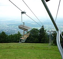
The Oberdorf – Weissenstein chairlift started operating in 1950 and was decommissioned in November 2009. With a length of 2339 m, it led in two sections from Oberdorf to the Kurhaus ( 1287 m above sea level ) and was considered the only preserved of its kind in Switzerland. The tunnel on the Solothurn- Moutier railway line from Oberdorf to Gänsbrunnen on the other side of the Weissenstein was opened in 1908 and is 3701 m long. The chairlift crossed the railway line of the Solothurn-Münster-Bahn (today part of BLS AG ) directly in front of the tunnel portal; this was the only such situation on a standard-gauge railway line in Switzerland.
The new wheelchair-accessible gondola lift Oberdorf – Weissenstein went into operation on December 20, 2014.
The pass road from Oberdorf over the Weissenstein Pass ( 1279 m above sea level ) to Gänsbrunnen is one of the steepest in Switzerland with gradients of up to 22%. It remains closed to private traffic in winter and then serves as a nationally popular toboggan run .
Via Balmberg and Grenchenberg, the Weissenstein can be reached by buses every day, a bus also runs from Oberdorf on weekends in the summer months.
Tourism and culture
Healing whey cures have been offered on the Weissenstein since the 17th century. The main building of today's Kurhaus was built in 1826/27.
A botanical garden with plants typical of the location and the winter sports museum can be visited free of charge at the Kurhaus .
Next to the Kurhaus are the "three brightest Solothurners", three powerful spotlights that shine into the valley and are clearly visible from afar at night.
The mountain chapel dedicated to Holy Brother Klaus was built below the Kurhaus in 1984 .
A hiking trail leads from the Kurhaus along the Weissenstein Planet Trail over the Hasenmatt to Grenchenberg or to the Balmberg .
Since 1994, the week is held annually on the Weissenstein World Music Festival Uhuru World Music Festival instead.
Web links
- Solothurn hiking trails
- Hugo Ledermann: Weissenstein geological hiking trail . Natural Research Society of the State of Solothurn, 1981.
- Weissenstein - do mountains also have tooth decay? ( Memento from May 26, 2012 in the Internet Archive ). Geological sights: glimpses into prehistoric times. Construction and Justice Department, Canton of Solothurn.
- Uhuru Festival on the Weissenstein
- Tobias Krüger: Weissenstein (Jura). In: Historical Lexicon of Switzerland .
swell
- ↑ Swiss Confederation: Ordinance on the Federal Inventory of Landscapes and Natural Monuments, Appendix 1 . Retrieved May 29, 2014.
- ↑ Cable car stops operating


